-
 14026 Hits
-
 84.82% Score
-
 19 Votes
|
|
Canyon |
|---|---|
|
|
40.07860°N / 9.71740°E |
|
|
Overview
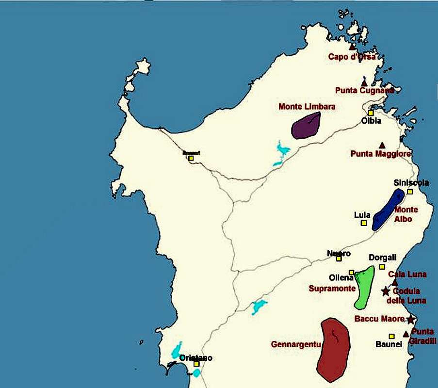
Charcoal burning used to be the main employment in Sardinia / Sardegna in the 18th and 19th centuries. Together with extensive agriculture - grazing sheep and goats it added to the meagre incomes of the rural population. Consequently much of the natural forests of the island disappeared leaving the high plateaus rather barren. Cases in point are the highest summits of Sardinia the Monti del Gennargentu, which for a very long time have resembled the Scottish Highlands rather than mountains in the colourful Mediterranean.
In order to transport the burnt charcoal to the ports mulatterias - mule trails - had to be established. But since Sardinia's east coast is almost inaccessible the task of finding and establishing proper routes through the Supramonte Costiera region turned out to be a major problem. Without the gorges which had been cut into the limestone by ages of erosion that task would rarely have succeeded.
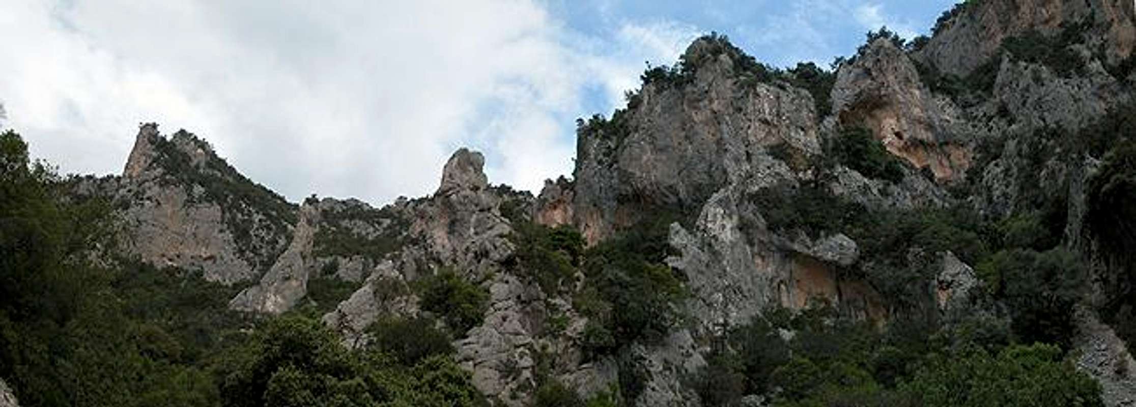
Baccu Maore is one of these gorges - steep at its western end within the Supramonte di Baunei Mountains - very narrow at the eastern end near Porto Quao, the natural port which was used to carry the finished product abroad. Along the gorge at various levels of altitude you can still see the remnants of the charcoal kilns. The gorge itself is so steep, exposed and narrow at places that you start to wonder how the mules could have been able to descend it.
The Baccu Maore gorge is host to some very bizarre limestone structures. Spiky spires, arcs and massive walls follow each other in varying order. It is a well know bouldering destination and the port of Porto Quao has a couple of short climbing routes directly above the sea. Moreover Porto Quao is located at the centre of Sentiero Selvaggio Blu, the extreme trekking trail that follows Sardinia's east coast between Pietra Longa (see the Punta Giradili Page) and Cala Fuili (see Cala Luna).
 |  |  |  |  |
Sentiero Selvaggio Blu
This trekking trail along the eastern coast of Sardinia - Sentiero Selvaggio Blu is - as trecking trails go - an extreme trail, since it contains passages of grade IV as well as some rappeling. The trail starts at Pietra Longa and runs through all the climbing areas of the east coast - Punta Giradili, Baccu Maore, Cala Goloritzé, Cala Luna - before it finally ends at Cala Gonone. The average trecking time for the whole trail is eight days. The trail is marked (by blue arrows) but much of it is overgrown so you need a quite good sense (and equipment) for orientation. |  |  |  |
Getting There
Sardinia can be reached either by plane or by ferry. The main ports are Porto Torres and Olbia in the north and Arbatax and Cagliari in the south. Airports are at Alghero and Olbia in the north as well as (again) Arbatax and Cagliari in the south. For exploring the north eastern part of the island where most of the mountains are the best entry point is Olbia, which is where most flights go anyway.Approaching the trailhead from Olbia airport
Get on motorway SS 131 south in the direction of Siniscola / Nuoro. At the exit Lula / Dorgali get off and turn onto SP38 south (again direction Dorgali). Shortly before you reach Dorgali, SP38 ends and you switch to SS125 direction Dorgali.
Get through the town (signs Cala Gonone, Baunei) and soon you'll drive along one of the most beautiful roads of the island above the Flumineddu valley. SS125 takes you to the mountain town of Baunei. In the centre of the town you have to look for signs "Rist. Golgo" where you turn left and head steeply upwards to the Golgo Plateau. This is a virtual Garden of Eden with all the farm animals grazing freely and happily on both sides of the road. When we were there, in late May, we saw a lot of newborn piglets, calves, lambs and foals. After 5km on the plain, at the third intersection turn right, then left and look for a spot to park your car. You are near one of the larger Nuraghes - prehistorical buildings which were abandoned when the Romans conquered the island. This one, the "Nuraghe Co 'e Serra", unfortunately is almost completely ruined.
Approaching the mountain from Arbatax airport
From the airport take SS125d towards Tortoli, where you switch to SS125 north, direction Baunei. From Baunei follow the description as given above.
From the trailhead near Nuraghe Co 'e Serra follow the road upwards in a south easterly direction. At the highest point you reach the entry to Baccu Maore, which is not very easily to be found. Look for a stone circle which marks the spot where a charcoal kiln once stood from there turn south (directly) and head for the edge of the gorge. From here you can see the trail, which first runs westward but soon turns into the general direction of the gorge - east.