
|
|
Mountain/Rock |
|---|---|
|
|
47.95753°N / 121.25136°W |
|
|
Snohomish |
|
|
Hiking, Mountaineering |
|
|
Spring, Summer, Fall |
|
|
5680 ft / 1731 m |
|
|
Overview
Bald Eagle Mountain is a mid-elevation peak located in the Henry M. Jackson Wilderness of the north-central Washington Cascades. The peak is located alongside a trail system which bears its name, yet the mountain is great overlooked by peakbaggers. On average, summit parties only occur at the peak once every 1-2 years. Northwest Side Of Bald Eagle Mountain
In the book "Cascade Alpine Guide: Volume 2" by Fred Beckey, only a brief description is given for the summit approach of Bald Eagle Mountain. The book implies that the summit is just a brief walk-up from the Bald Eagle Mountain Trail. Other resources have made similar implications. Although that description is basically correct, it does not tell the entire story.
Every side of Bald Eagle Mountain has very steep slopes. The north face of the peak even has a dramatic rock cliff. Summiters must go up a steep ridgeline full of young evergreen trees, heather, and huckleberries. Although at no point should someone need to crawl on the ground or scramble over rocks along the standard summit route, veggie belays (which some people might refer to as "Class 3/4 plant assist") are necessary due to the steepness of the terrain and semi-solid groundsoil.
 Steep North Face Cliffs
 Huckleberries And Heather Slope
Due to the steep slopes involved, Bald Eagle Mountain is recommended for the main hiking season between mid-July through mid-October, and only during dry periods. It is possible to ascend the peak with snow conditions, and summit attempts in late Spring/early Summer are not unheard of. If covered with snow, the steep slopes leading to the summit would require the use of an ice axe.
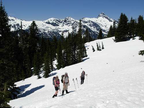 Snow-Covered Ridge North Of Bald Eagle Mountain
There are fantastic views from the mountain, especially to the north and east, including Glacier Peak. From the standard approach trail there are also fantastic views to the west toward the Monte Cristo Range, as well as of Sloan Peak and nearby Wild Sky Wilderness.
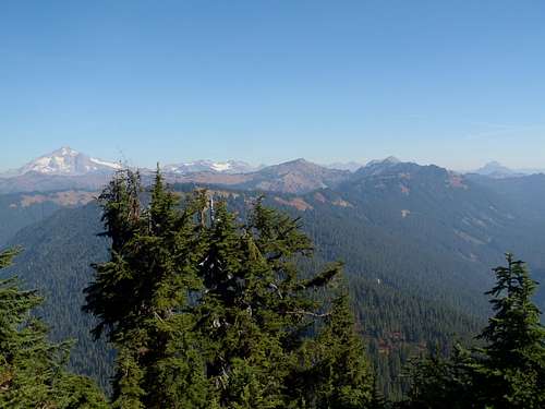 North/East View
 Monte Cristo Range, As Seen From Bald Eagle Mountain
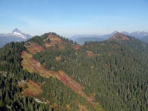 Sloan Peak and the "Bowser Buttes", As Seen From Bald Eagle Mountain
Getting There
DRIVING DIRECTIONS:
1) Along Highway 2 a short distance east of Skykomish, turn left (north) onto Forest Service Road #6500 (a.k.a. FS-65, Beckler River Road).
2) Follow FS-65 for 14.4 miles, until an intersection with FS-63.
3) Turn right onto FS-63 and follow for 4.2 miles to the Quartz Creek Trailhead (~2500' elevation). There are three trailheads at the parking area; Quartz Creek Trail begins on the north side of the parking area.
------------
HIKING DIRECTIONS:
1) Hike north along Quartz Creek Trail (#1050) for 4.0 miles to Curry Gap.
 Curry Gap
2) At Curry Gap, turn right (southeast) onto Bald Eagle Mountain Trail (#650).
 Junction Sign For Bald Eagle Mountain Trail (#650)
3) Follow Bald Eagle Mountain Trail for approximately 2.75 miles, until reaching the mountain's northeast ridge where the trail takes a sharp left (east) turn.
 Heading SE Along Bald Eagle Mountain Trail (#650)
4) Leave the trail and begin steeply ascending the ridgeline. The ridgeline is narrow is some places and broad in others, but is consistently comprised of young evergreen trees, heather, and huckleberries.
RECOMMENDATION: It is best to stay near trees where possible, as they are much stronger/reliable to hold onto (if needed) than heather and huckleberries.
5) After nearly 0.25 miles, reach the meadow summit.
NOTE: A small rock cairn is on the summit, which may contain a small summit register.
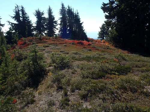 Summit Area
 Small Rock Cairn Marking Summit Location
------------
ESTIMATED ELEVATION GAIN:
Quartz Creek Trailhead to Curry Gap: 1400' elevation gain
Curry Gap to Bald Eagle Mountain's northeast ridge: 1200' elevation gain
Lower northeast ridge to summit: 600' elevation gain
TOTAL: 3200' minimum elevation gain (in addition to minor ups and downs along the trail system)
ROUNDTRIP HIKING DISTANCE:
Approximately 14 miles.
Alternate Route Options?
NORTHWEST RIDGE:
Bald Eagle Mountain Trail (#650) first passes by the northwest ridge of the mountain. Maps show many sections of that ridge being less steep than the northeast ridge which is used for the standard approach. However, what the maps do not show is a massive rock rib that prevents ascent/descent progress, and several knife-edges (with exposed drop-offs) which occur on the northwest ridge. The northwest ridge is NOT recommended for attempts.
------------
SNOWY ASCENTS:
In general, due to steep terrain and multiple side-traverses, summit attempts during periods of snowpack are not recommended for this peak. However, snowy attempts are only feasible after avalanche danger has passed (typically in June or beyond) using the right precautions and advisories.
1) Prior to reaching Curry Gap, there are at least two major gullies leading up the western slopes of the ridge located a couple of miles north of Bald Eagle Mountain. These gullies are very steep, so use of an ice axe (and at least one trekking pole) will be needed. When nearing the top of one of these gullies, angle right. Both large gullies reach the Bald Eagle Mountain Trail at approximately 4700' elevation. Depending on conditions, some people might opt to side-traverse the general route of the trail, or opt to go further up to near the ridgeline and then continue southeast along it.
 Looking Up Large Gully...
 Looking Down Large Gully...
2) The north slopes of Bald Eagle Mountain are very steep. When not covered with snow, the trail system leads by the north side of the mountain without issues. However, if the trail is covered by snowpack, this area would be very susceptible to avalanches and a side-traverse using an ice axe would be necessary.
3) The northeast ridge would be a steep snow climb, using an ice axe and probably also at least one trekking pole. In some aspects, it might be easier and more straightforward with all-snowpack rather than Summer/Autumn brush. However, the steepness of the terrain and exposure to the west of the ridge need to be taken into serious consideration.
Red Tape
A Northwest Forest Pass (parking permit) is required to park at the Quartz Creek Trailhead.Camping
The nearest official campgrounds are San Juan Campground and Troublesome Creek Campground, located only a few miles west along Forest Road 65 beyond its junction with Forest Road 63.Backcountry camping is allowed within Henry M. Jackson Wilderness. However, there are few such viable locations along the standard approaches for Bald Eagle Mountain. One option is at/near Curry Gap. Another option is to bivy at the meadow summit of Bald Eagle Mountain, which is protected from much direct wind due to surrounding treecover.