
-
 3504 Hits
-
 71.06% Score
-
 1 Votes
|
|
Route |
|---|---|
|
|
42.98898°N / 1.99283°W |
|
|
Hiking, Mountaineering |
|
|
Spring, Summer, Fall, Winter |
|
|
Half a day |
|
|
Walk-up |
|
|
I |
|
|
Overview
It's an interesting route to know the first little Malloas of the east to the summit of Ttutturre and a good option to begin the full traverse of Malloas.Slope: 650m
Time: 3h + 2h
Getting There
 Lekumberri
For approach to Aralar take direction to Pamplona, the most important city neary to Aralar. From Pamplona take the highway A-15 to Alsasua, take direction Donosti/San Sebastian to the village of Lekumberri (inverse if you come from Donosti or Vitoria to Lekumberri before Pamplona).
From Lekumberri we take the road of Santuario de San Miguel in Excelsis just in the entry of the village near of the crossroad to camping Aralar. After a few of km we reach the village of Baraibar (635m).
Generally if you want to climb Ttutturre we begin the route in the village but if our intention is the climb of all the Malloas (with another car in Gaintza or Azkarate) we can to follow the track to the antenna in the hill of Dolboa (905m) to park the car and to reduce the long itinerary.
Route Description
 Uarrain & Alborta
We get the track in direction to the antenna, after some meters we turn to the track of front and in the second we get a path to leave the track (to evitate a long curve) to reach the hill of Dolboa (905) with a lot of antennas. After a little descent we reach the hut (borda) of Izarrite (880m). The track with stones go in the forest between the hills of Gaztelu (1080m) and Txurtxur (1055m). We leave the forest of beeches in a fence and the last paths of the route. From this point the route is out of path and the reference are the peaks and the cols.
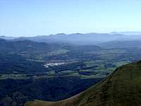
We go to west in direction to the huts of the plain of Etzantza and we climb the slope of the peak Arriolatz (1176m, 2h) and descending to a col we attack the peak Uarrain (1224m, 2h 15min). The lanscape is very good and we see the cone of Ttutturre in NW. We descent to another col and we climb the ramp of Alborta (1228m, 2h 40 min) signaled with a mailbox.
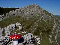 Ttutture from Alborta
The route is evident from here and we can to see the access of the summit of Ttutturre in right side evitating the rocky ridge of left side. The col under us is the entry of normal route from Albia.
Walking the zig-zag of the ramp west and climbing the last rocks (very easy, grade I) we reach the summit of Ttutturre (1282m, 3h)
The descent is across the same itinerary but we can to evitate some peaks bordering to the cols.
Essential Gear
Map it's advisable, compass,... the green plains of Aralar are confuses.Some days of winter Aralar had a lot of snow and the use of winter material it's advisable in the access to summit (long fall to north).