
-
 39374 Hits
-
 83.69% Score
-
 17 Votes
|
|
Mountain/Rock |
|---|---|
|
|
40.13100°N / 79.159°W |
|
|
Somerset |
|
|
Hiking, Sport Climbing, Toprope, Bouldering, Scrambling |
|
|
Spring, Summer, Fall, Winter |
|
|
2661 ft / 811 m |
|
|
Overview
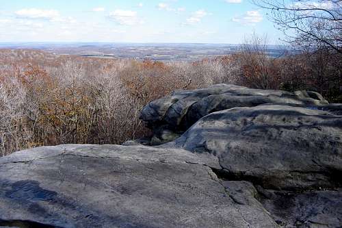
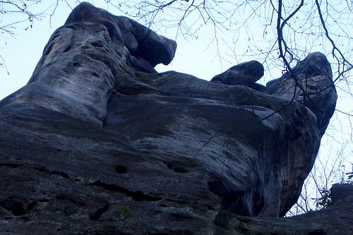
Beam Rocks rises 90 feet above the Laurel Highlands trail near the 40 mile post. However, the top of the rocks is just a short quarter mile hike from its small parking lot along Laurel Summit Road.
Beam Rocks offers views to the East of the Laurel Ridge into Somerset County and nearby Jennerstown. The rocks are a favorite with local rock climbers so be prepared for crowds. Please see the climbing website referenced below for additional climbing information.
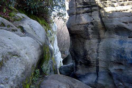
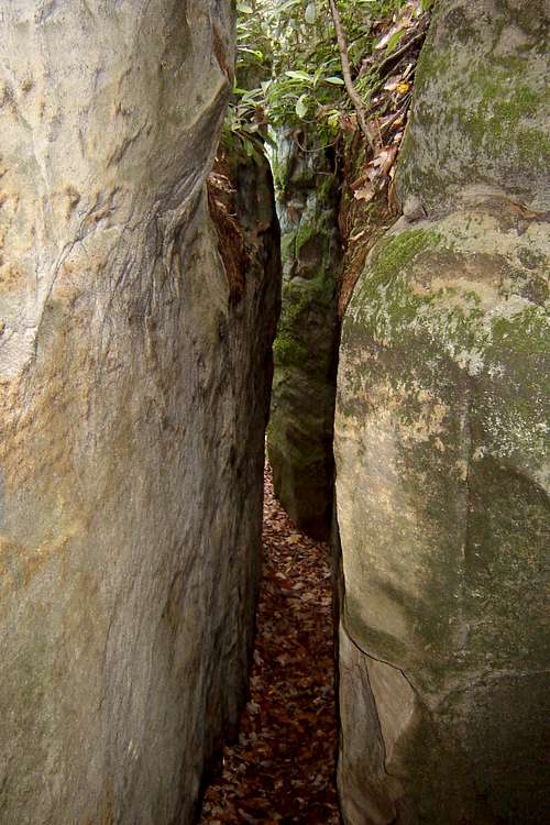
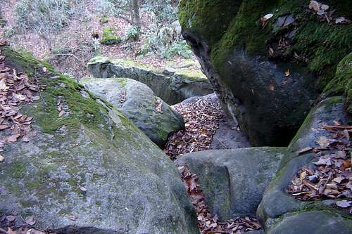
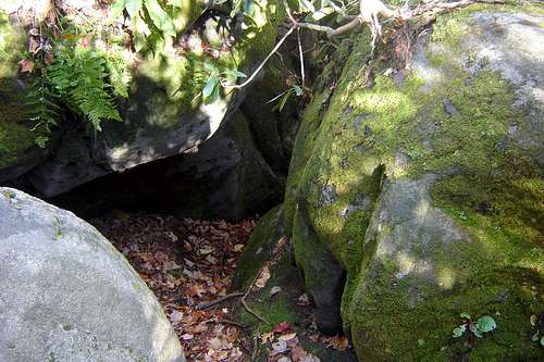
For the less adventurous there are narrow slots and caves within the outcropping that can be explored. Beam Rocks offers a more spectacular experience (higher outcropping and better views)than nearby Wolf Rocks, but offers less quiet, solitude and wildlife viewing opportunites.
BE VERY CAREFUL as some of the paths within the rocks lead to sudden dropoffs, in the fall the wet leaves can make these areas extremely slippery and dangerous. Also, be aware of the rattlesnakes that often sun themselves on the warm rocks in the spring, summer and fall .
Getting There
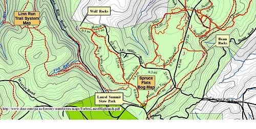
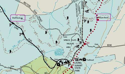
Take the Donegal Exit of the Pennsylvania Turnpike (34 miles east of the Pittsburgh exit). Take State Route 711 North to Ligonier. Turn Right onto Route 30 East through Laughlintown and past the Forbes District Forest office. Turn right onto Laurel Summit Road go six miles to the Laurel Summit State Park parking lot.
You can also follow the signs from Rt 711 to Linn Run State Park and follow Linn Run Road through the park and up to Laurel Summit Road. This is a somewhat more scenic route which also affords the opportunity to take in the beautiful Adams Falls hike within Linn Run State Park.
Red Tape
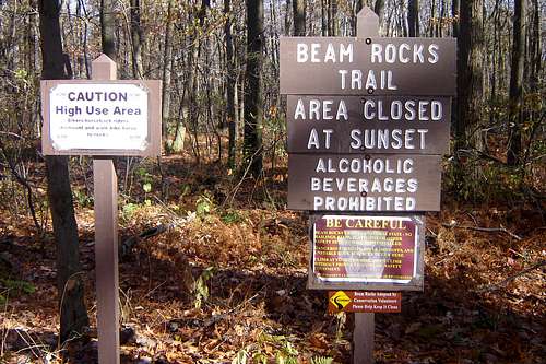
There are very few restrictions and the trail can be hiked year round, as long as snow is cleared from the roadway. Be aware that this windy ridge is much cooler than the surrounding valleys and gets much more snow than the rest of south western PA.
However, there are regulations if you intend to hike the nearby Laurel Highlands Trail. The 70 mile trail that follows the Laurel Ridge from Ohiopyle on the SouthWest to Johnstown in the NorthEast end.
Laurel Ridge Hiking Trail
This major 70-mile hiking and backpacking trail from Ohiopyle to near Johnstown is the main feature of the park. The trail traverses state parks, state forests, state game lands, other public lands and private lands.
The Laurel Highlands Hiking Trail is open year-round and is blazed approximately every 100 feet with 2-inch and 5-inch yellow blazes. Connector trails lead to and from parking and shelter areas and are marked with blue blazes. Mileage monuments are every mile.
A Hiker’s Guide to the Laurel Highlands Trail is available from the Pennsylvania Chapter of the Sierra Club, P.O. Box 8241, Pittsburgh, PA 15217. The guide describes the trail and aids in planning outings. Included in the guide are detailed topographic maps plus information on geology, climate, plants and wildlife.
Large wooden signs mark trail access points at every major highway crossing. Six 30-car parking areas provide starting points and water. In addition, voluntary day use registration booths are located in each of the parking areas and the trail user is encouraged to fill out information cards for vital park Attendance data and for use in the event of an emergency. For overnight use of the trail see below Laurel Highlands Trail Regulations.
No horses, bicycles or motorized vehicles are permitted on the hiking trail or in the shelter area.
Pets are prohibited in shelter areas.
Alcoholic beverages are prohibited.
All garbage must be placed in provided refuse containers. Refuse containers shall not be removed from designated “pick-up” stations. Burying garbage is prohibited.
Horseplay and climbing onto the roofs of buildings is prohibited. These activities not only damage park resources and facilities, but also can lead to serious or fatal accidents.
When backpacking, hikers can be many hours from medical attention.
Please no frivolous 911 calls.
Responding emergency personnel and equipment may be at your expense.
Potomac Heritage National Scenic Trail
The Laurel Highlands Hiking Trail is a segment of the Potomac Heritage National Scenic Trail. An enterprise of many partners, the evolving trail network celebrates the heritage of the Potomac and upper Ohio river basins and offers opportunities for hiking, bicycling, boating, horseback riding, and cross-country skiing. National Park Service Passport Stamps for the trail are available at the Laurel Ridge State Park Office and at the visitor center in Ohiopyle. For more information, visit www.nps.gov/pohe.
Camping
Regulations: To protect hikers and the trail, the following regulations have been established:
Overnight Reservations are Mandatory
Reservations for the entire trip are mandatory. Reservations can be made up to 30 days in advance, but will not be accepted more than 30 days in advance. Reservations for the use of tent sites and camping shelters along the entire length of the hiking trip will be made on a first-come first-served basis.
An overnight camping fee is charged per night/per individual in the backpacking party.
For current rates, please contact at the park office at 724-455-3744 or call 888-PA-PARKS for a current Pennsylvania State Parks Price Guide.
Contact the park office at 724-455-3744 for reservations and additional information. Summer Season - The park office is open from 8 a.m. to 4 p.m. daily from Memorial Day to Labor Day. Off Season – The park office is open 8 a.m. to 4 p.m. Monday through Friday. It is closed weekends and holidays. However, phone reservations can be made 24 hours a day, 7 days a week through the park voice messaging system. Park personnel will return your call the next business day.
Camping is only permitted in the shelter areas and overnight stays are limited to one night at each shelter area.
Backpacking groups are limited to the use of one shelter at each overnight stop.
A typical shelter can accommodate from four to six campers. Areas adjacent to the shelter are available for setting up campsites for additional backpacking party members. All excavations for wet weather tent drainage must be filled in to the original grade before departure.
One responsible adult (18 years of age or older) is required to accompany each 10 campers.
The responsible adult for each backpacking party must phone the park office prior to starting an overnight trail hike to register the backpacking party. Please be prepared to provide the following information when you call the park office to register your hiking party:
Group Leader Name
Group Leader Address
Emergency Phone Number and Cell Phone Number (if one is being carried during the trip)
Date(s) of Overnight Stay(s)
Name of Shelter Area(s) your group will be using
Name of Entry Point to the trail
Description of Vehicle(s) left at designated parking area(s) (please do not leave valuables in vehicles)
Number of people in the hiking party
Backpacking groups are limited to the use of one shelter at each overnight stop.
Park rangers may verify your reservations each night at all shelter and tent areas.
Campers must clean and remove litter daily at: toilets pump platforms and surrounding areas, parking areas and campsites.
Dispose of dishwater in latrines and do not use sinks for personal hygiene. In no instance will dishwater be disposed of on a campsite or in an adjacent area. This causes unsanitary conditions for the camper and the next user of the site. Unsanitary conditions attract skunks, raccoons, mosquitoes, flies and ants.
Fires are only permitted in camp stoves, fireplaces or in designated locations.
Fires must be extinguished when unattended. Leave all ashes in the fireplaces and do no rake them onto the ground. This prevents ashes from entering the shelters during wet weather.
External Links
RockClimbing.com website for Beam Rocks
also
PA State Park Guides
also
PA DCNR Topo Map of Laurel Highlands Trails
Area Trail Map
References
Donna Ruff's "60 Hikes Within 60 Miles of Pittsburgh" book published by Menasha Ridge Press in 2006
and
The PA DCNR Online Park Guides