
-
 9511 Hits
-
 74.01% Score
-
 4 Votes
|
|
Route |
|---|---|
|
|
48.83650°N / 121.5864°W |
|
|
glacier, couloir, and technical rock |
|
|
A few days |
|
|
IV, 5.4? |
|
|
Approach
See the Nooksack Tower main page.
 |  |  |
Route Description
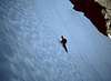
A glacier approach leads to a 50+ degree, 800-foot (240m) snow & ice gully, then to another 800 feet of rock climbing, ranging from class 3 to perhaps 5.4. Objective hazards include crevasses, a bergschrund, steep snow/ice, avalanches, and steep, loose rock. While a fast party can do it in a weekend, our threesome took until mid-afternoon Monday to get home.
From the ridge separating the Price and East Nooksack Glaciers, traverse and climb to the base of the snow gully. Although we hiked fairly directly toward the route's start, allowing for crevasses, on the return we found a safer route following an arc closer to the rock ridge and face.
At about 7,200 feet (2200m), reach the base of the couloir that bounds the E side of the Tower. Climb over or around the double bergschrund and start up the couloir.
Be There or Be Square variation (BTOBS), 1981: The bergschrund and gully scared us enough that Larry Rasmussen, Derek Franzen, and I climbed onto the rock a couple hundred feet (60m) E of the couloir, where the lip of the glacier had broken off and bridged the 20-foot (6m) wide moat. Three pitches of tolerable rock took us up and right to the left side of the couloir, where we merged with the standard route. The drawback was that when we descended, we may have been able to go straight down the couloir, jump the 'schrunds, and walk out onto the glacier. Not having come that way, we weren't sure, and since it was dark by then we didn't want to experiment. We went back the way we came, and because of the traversing nature of the route and the limited range of our headlamps, we took five rappels to descend what we'd climbed in three easy pitches. Some of the anchors would inspire nighmares, in spite of long searches for better placements and our investment in hardware to get down. Those chocks may stil be there, if you want them.
Pickets or screws may be in order for the 800 feet of snow and/or ice. We relied on rock protection along the left wall and found it scarce and uninspiring. A large semi-natural snow bollard near the top may have been our best pro. We ran the couloir as a single pitch, belaying from the rock where we entered it and from a small schrund at the top. The top is not the ridge crest, but the top of the wide portion of the couloir. Where it narrows suddenly, exit right onto a rock ramp/gully that takes you to the crest of the north butress of the Tower. We found room to change into rock shoes about 20 feet off the snow, then climbed to the crest unroped. Climbing was steep enough that any of dozens of portable holds could do you in. Be careful.
Once completely out of the gully we roped and belayed the rest. The route culminated in about a ropelength of near-vertical, near-solid face. The top of that pitch turns out to be a shoulder of the mountain - the right-hand corner in Scotts black & white photo on the main page. The summit is about 60 feet (20m) higher, and maybe 200 feet (60m) S. Much of the intervening ground is exposed, loose rocks, and we were 'way past being out of time, so we didn't finish the climb.
Descent takes a long time. The same lousy rock you tried not to think about when you were setting protection is now holding your rappel anchors. Both guidebooks I've read emphasize that you do not want to rappel E for a shortcut down the narrow, upper portion of the gully. I believe them. Rappel the route. At the ledge 20 feet above the snow we donned boots and crampons, then rappelled into the upper 'schrund. We backed down the central ice chute until we realized we were below our side exit for the BTOBS variation, so we reversed and climbed up until Larry could exit the chute and traverse the side slope to the rock. Derek has the hair-raising details in his trip report.
 |  |  |  |  |
Essential Gear
We carried an almost-full rack to 2 inches (50mm), two 50m ropes (for a threesome), ice axes, crampons, and rock shoes. We missed having a few pickets and/or ice screws.