
|
|
Route |
|---|---|
|
|
38.80000°N / 107.53°W |
|
|
Hike |
|
|
Half a day |
|
|
Class 3 |
|
|
Approach
Follow the directions to the trailhead as found on the main page.
 |
Route Description
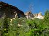
The climb starts out steeply as it climbs up into the canyon. This is just a preview of upcoming events, the rest of the trail will get much steeper. After this first initial climb, the trail levels out as it follows the stream at the bottom of Bell Canyon. After a while the trail starts to switchback steeply as it climbs up higher into the canyon. The trail continues climbing up along the stream and in the beautiful woods and its interesting to see the change in vegetation as you climb higher. The hike through the canyon is just over two and a half miles long but it seems interminable. Multiple stream crossing, downed logs, and very thick vegetation make this hike seem very long, and can considerably slow your progress.
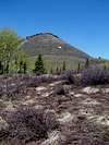
From the end of the canyon follow signs for Mt. Lamborn summit. At this point the trail climbs out of the trees and starts climbing steeply up Lamborn's south slopes through scrubby bushes. After this steep section the trail levels out once again and climbs through an aspen forest to a saddle between Lamborn and a subpeak. From here continue through an aspen forest to yet another saddle. Here you can view the tough final pitch before the short summit ridge. A small climbers trail leadsup this very steep slope that approaches forty five degrees in places. Fortunately the slope is grass and not scree or talus, but you must be careful that you don't roll an ankle.
After this final pitch you will top out on the final rocky summit ridge, and the terrain changes considerably while the exposure increases significantly. From here you can see the rocky summit block a short scramble away. Stay on the right side of the ridge to avoid the massive exposure, and scramble the remaining few feet to the summit. The final summit rock is flat though only large enough for about eight people. The whole place is great for taking a nap (provided that the weather is nice) and looking so far down from the summit is an awesome experience.
Descend the way you came, though the descent through the canyon seems as though it will never end.
 |  |  |
Essential Gear
Waterproof hiking boots are highly recomended since you will get wet while hiking through the canyon. Though I did the hike in shorts you might want to do in pants because of the heavy vegetation. Bug spray might be useful to keep off the ticks and other pests. This of course is in addition to all the other regular gear would bring for a day in the Colorado mountains.
Miscellaneous Info
If you have information about this route that doesn't pertain to any of the other sections, please add it here.