
-
 19799 Hits
-
 75.81% Score
-
 6 Votes
|
|
Route |
|---|---|
|
|
40.53813°N / 111.76156°W |
|
|
Hiking, Mountaineering |
|
|
Half a day |
|
|
Walk up |
|
|
Overview
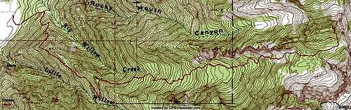
Rocky Mouth Canyon Peak is the 27th highest peak within Salt Lake County. It sits at the eastern terminus of the ridge separating Rocky Mouth Canyon and Big Willow Canyon. It is very seldom climbed as it shares no standard approach with any other peak and is completely overshadowed by its neighbor to the south, Lone Peak.
Big Willow Canyon is the canyon directly south of the peak. It offers the serenity ofmeadows, pine forests, and an alpine cirque just miles from a major city.
Getting There
The Big Willow trailhead is at a park located adjacent to an LDS stake center at 11570 S Wasatch Blvd, Sandy, UT 84092.
Driving south on Wasatch Boulevard it is approximately 2.7 miles from Little Cottonwood on the left side of the road. Coming from I-15 get off at 12300 South and drive east following the road as it curves to the North just past 1300 East. At the first light after the curve, turn east onto Wasatch Boulevard. It is approximately 1.7 miles to the Stake Center.
Don't park at the church itself, but rather Hidden Valley Park, just to the south. From here just walk up the asphalt trail toward the mountains. Turn left at the first benches on the dirt trail cutting North.
Stats
Trailhead Elevation: 5110
Summit Elevation: 10292
One-Way hiking mileage: ~4.6
Elevation Gain: 5182
Route Description
From the Hidden Valley Park parking lot walk east on the asphalt trail and go north at the first left (marked by some park benches). Take this trail (an old road) up past the first gate, simply walking around it. Just under half of a mile, the road will turn east into to mouth of the canyon. Soon after, turn right on the trail marked "Sawmill Trail". The next part of the trail is the steepest. In under a half mile you will gain around 700 feet. Persevere and soon you will find yourself at the top of the log flume. The trail gets less steep at this point, and after not too long, turns into Little Willow. about 1.6 miles into the hike you will encounter the avalanche sign.
Continuing past it will take you to a nice waterfall, but for this route you need to hang a sharp left on the switchback. Follow it to the top of the ridge and back down into Big Willow. The next portion of the hike is the nicest, traveling on easy terrain through a pine forest, crossing a pretty stream. After the forest the vegetation changes, but simply follow the trail on up the canyon.
The trail has some logs on it but is mostly easy to follow if you pay attention to where it's going. At around 8500-9000 feet I encountered snow and headed straight uphill. I know there are switchbacks I ignored/couldn't see. At the top of the canyon, instead of heading into the cirque, stay on the north side of the canyon, heading east toward the saddle between Big Willow and Bells. Once at the saddle, go straight up the south ridge to the summit (class 2).
From about the Pine Forest on, there are pink tags tied onto branches. At first I found this completely unnecessary, but it got handy as the trail began to be harder to follow in the mid- to upper-canyon, especially on snow. Don't count on them to be there of course, and if they aren't, you'll be alright if you have any route finding abilities.
Essential Gear
Summer:
10 essentials, good boots, trekking poles recommended.
Winter:
In the dead of winter skis or snowshoes would be necessary, as well as any gear. I doubt an ice axe and crampons would be needed.
Spring:
An early season ascent will bring conditions I saw. Standard summer hiking for the lower half, then an ice axe and crampons would be needed.
External Links
Google Earth overlay of my GPS track. Requires Google Earth (free download).
Download
Moogie737 - Nov 23, 2016 11:32 pm - Hasn't voted
Helpful trail markingsNovember 2016 Some kind soul has placed many red metal trail markers on key trees along the route up to the hanging canyon. Older plastic markers still remain, but the newer ones are more frequent and greatly assist in staying with the trail.
AGMonks - Jul 11, 2022 6:15 pm - Hasn't voted
Great TrailHiked on a July Monday morning. Had the trail to myself - didn’t see another soul all day. Started at 6am and it took me about 5.5 hours round trip, not counting breaks. My GPS track showed just a hair over 5 miles from the parking lot to summit. The big thing I’d do differently is bring bug spray and a head net. Once you hit the wildflower zone about 8500-9000 feet, the bugs come out. At the upper two meadows right before you turn off trail to climb to the summit, the mosquitoes were horrific. Like Alaska tundra bad. Don’t cut straight through the meadows - skirt left (north) on the high ground where the bugs aren’t quite so bad. The meadows are dry, but there are stream crossings about 1/3 and 2/3 of the way up.