
-
 3764 Hits
-
 74.92% Score
-
 5 Votes
|
|
Route |
|---|---|
|
|
32.41410°N / 110.7092°W |
|
|
Hiking |
|
|
Spring, Summer, Fall, Winter |
|
|
Less than two hours |
|
|
Overview
 Mount Bigelow from Highway
This super-short, wishbone-shaped routing is a great outing for those pressed for time, low on energy, or just wanting a shorter day out in the mountains. The Mount Bigelow summit is reached entirely on-trail and, while there are a few forks to consider which may/may not show up on a map, the route to the top is straightforward. While the visitor must leave the trail to summit Kellogg Mountain, the off-trail segment is short with good line-of-sight.
Roundtrip Distance: 2 miles
Net Elevation Gain: 700 feet
Max YDS Class: Class 2 (due to brief off-trail)
Getting There
This trailhead can be accessed within one hour’s drive of downtown Tucson. Take Tanque Verde (often pronounced “TANKy VURdy by the locals) diagonally across the northeast edge of town to East Catalina Highway. Follow East Catalina Highway North for about 4.5 miles to the Forest Service boundary. Here the road becomes the General Hitchcock Highway…or the Catalina Highway…or the Mount Lemmon Highway. Follow the twisting, scenic road for nearly 20 miles to the small trailhead which will be on your right. This trailhead is across from the Palisades Visitor Center, which is at milepost 19.9 on the General Hitchcock / Catalina Highway.US Forest Service Map

Route Description
 My boys at the summit of Mount Bigelow
 Bigelow from Kellogg
• Depart the parking area heading generally northbound away from the road.
• The route ascends gradually, traversing to the northeast a southern ridge-lette of Mount Bigelow and traveling through Ponderosa Pine forest studded with rock outcrops.
• After passing under a rocky area, the route continues mostly northeast toward the saddle between Mount Bigelow and Kellogg Mountain.
• At the saddle there is a trail junction with a footpath heading toward Westfall Knob. Turn west here toward Mount Bigelow and begin ascending its eastern slopes. Though some maps may indicate a footpath running directly from the saddle to the Mount Bigelow summit, in fact a trail traverses to the west under the summit before connecting to the service road to twist back east to the summit radio towers.
• After enjoying the Mount Bigelow summit, descend back to the saddle.
• Leave the trail near the junction and ascend the gentle western ridge of Kellogg Mountain.
• The south side of the mountain has been burned but even with the downed logs provides easy passage.
• Step up through low-angle scree to a flat summit area.
• Descend westward down the slopes of Kellogg Mountain and regain the trail to return to the parking area.
Essential Gear
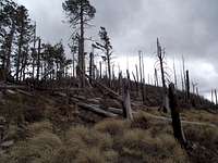 Fire remnants on Kellogg
 At the Kellogg Mountain summit
• Standard hiking gear appropriate to the season will be sufficient.
• The National Forest Service General Hitchcock Highway area map is helpful for finding the trailhead.
• Finally, carry a decent topo map that enables you to identify landforms to navigate past a few of the non-trails in the area. I used the Green Trails Map #2886S Santa Catalina Mountains.