
-
 11163 Hits
-
 78.27% Score
-
 9 Votes
|
|
Canyon |
|---|---|
|
|
37.32007°N / 112.8754°W |
|
|
Hiking, Scrambling, Canyoneering |
|
|
Spring, Summer, Fall, Winter |
|
|
Overview
Birch Hollow is an excellent beginner slot canyon with incredible twisting rock formations offering unique scenery hidden in the depths of the Zion National Park area. Descending 1,400 feet from the trailhead, it takes you quickly down to the famous Orderville Canyon, where a number of return options exist. Although the canyon does not lie within the park, it's very close by, and you will feel the bustling nature of the scenic drive here, especially since this canyon is quite popular. This canyon is rated at 3A III with the only difficulties being some long rappels, however all the anchors are two bolt/chain anchors so very little anchor building knowledge is needed. You will often find guided parties, and large groups here so if you come expecting solitude, perhaps best to go on a weekday. Also, Birch Hollow does not have any water/potholes to deal with so cold water gear is also not needed. The longest rappel is the first big drop and is right at 35 meters, however with a 60 meter rope you can still descend the entire canyon if you take the bypass route heading around the first drop.
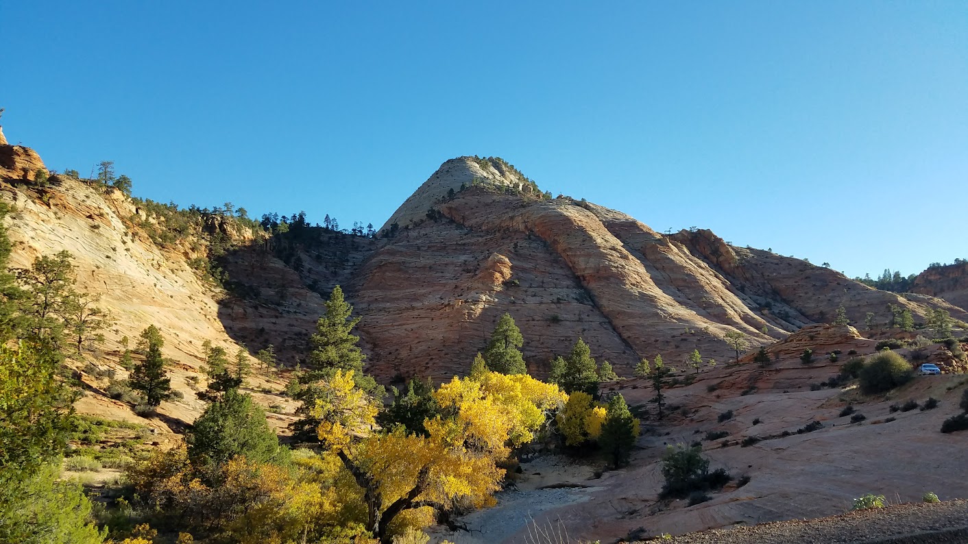
Fall foliage on Highway 9 near the east park boundary
The Route
Everything you see online about this canyon will describe either a car-spot (meaning you need two cars) at the Orderville Corral, a mountain bike spot, or a very long hike down Orderville Canyon which passes into the National Park and through the famous Narrows (permit required). This hike down Orderville would be a multiple day trip! If you don't have an extra car or mountain bike, there is an easy way to park at the main trailhead for Birch Hollow, and return to the same spot without a super long road walk. This will be the route I will describe, since you won't see any other information about it elsewhere.
The main trailhead for Birch Hollow is located on the North Fork County Road, 8.5 miles north off State Highway 9. Get here from Zion by driving through the Mount Carmel Tunnel, and exit the east side of the park and drive another 1.8 miles east from the park boundary. Turn left (north onto the North Fork County Road and drive 8.5 miles on this good gravel road to the trailhead, passing the Zion Ponderosa Resort en-route. The trailhead is a small parking area right where the road crosses the Birch Hollow dry wash, which heads down to the west. A sign here confirms you are at the Birch Hollow Trailhead.
Begin hiking down the wash following a nice, but narrow trail. The wash is quite small and not very deep, and it's about a mile walk until you reach the first big drop, where you have two options. You can either rappel down from a tree right over the overhanging 35 meter drop (best to belay beginners since this rappel has an awkward start), or you can follow a faint trail leading left, up and over a small hill and steeply down through the trees to the left (west) side of the drop. This path is slick but not too difficult and ends in the wash below the rappel by a couple large logs. If you don't have a 70 meter rope, you will have to take this bypass route. The rest of the canyon is a very fun, rappel crazy adventure that I've described in the table below. There are a handful of other smaller drops that can either be rapelled or downclimbed by more experienced canyoneers ranging from 8-20 feet in length that are not listed below as well.
| Rappel | Photo | Length | Description |
| 2 |  | 28m | From the bottom of the first big drop, continue down the wash another 0.3 mile to the second big drop, and rappel from an excellent tree anchor down a smooth wall. Shortly after this rappel the canyon narrows, and deepens considerably. |
| 3-5 |  | Varies | Make a series of short rappels (ranging from 10-25 feet) down the upper part of the slot canyon. This section is very scenic but not very deep yet. |
| 6 |  | 25m | After a short 30 foot walk down the slot canyon, rappel off a tree just off to the left straight down a smooth chute to the now deep canyon floor. Enjoy the darkening and somewhat creepy slot canyon. From this point you will remain in a deep slot until the end. |
| 7 |  | 15m | Just around the corner is a short rappel off a bolt anchor. |
| 8 |  | 15m | Another straight-forward rap off of two bolts on the right down another chute. Hike down canyon a bit and down-climb a little 8' tall boulder obstacle. |
| 9 | 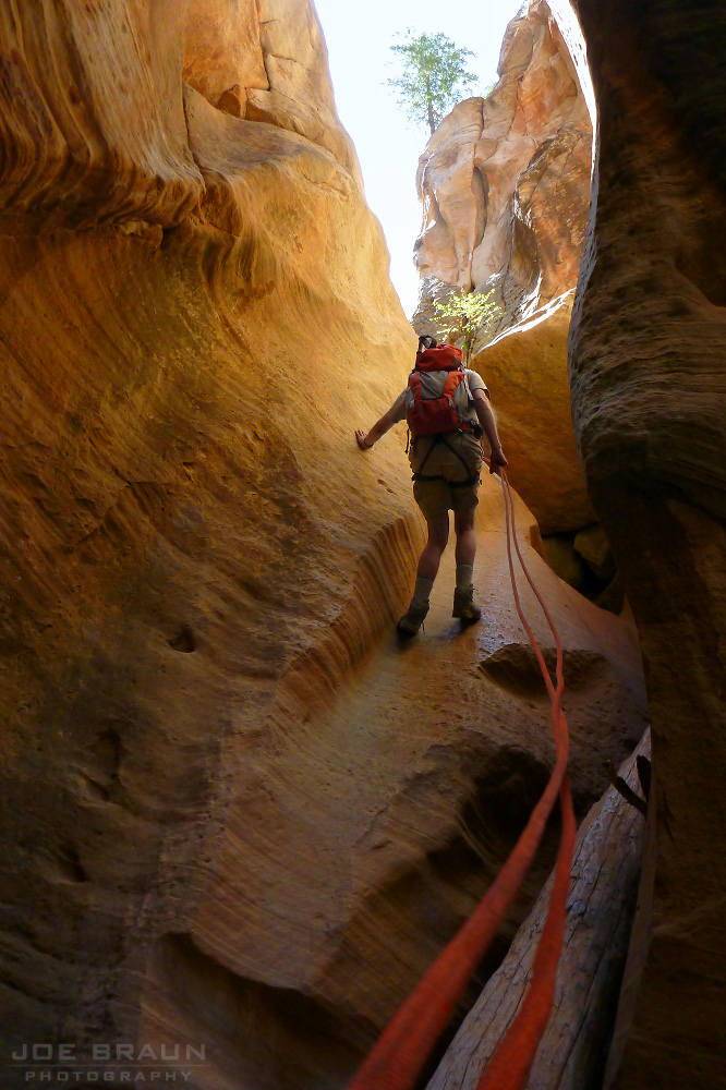 | 11m | This one is off of two bolts on the right, and heads down another chute that usually has a bunch of of logs at the bottom. Right around the corner is the grand finale! |
| 10 | 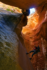 | 25m | This is probably the best rappel in the canyon. You drop straight down through a twisted chamber with excellent opportunities for some incredible photos. No easy way to describe this spot other than to say it's unlike anything I have ever seen (See photo to the left!) |
| 11 | 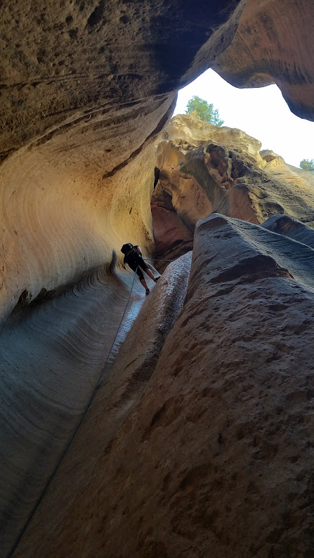 | 18m | A wonderful rappel down a double flute ends at the ground. Fifty feet away Birch Hollow meets with Orderville Canyon. |
Exit Options
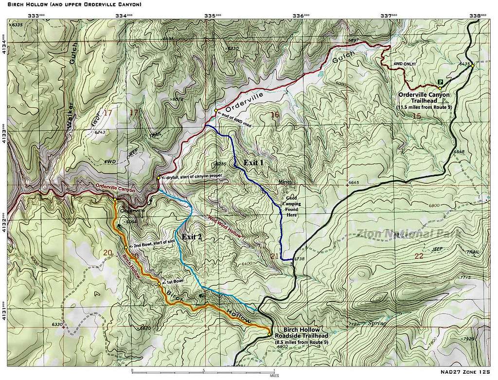
There are a few ways to return to the roadside trailhead from where you began. If you were able to spot a car or bike at the Orderville Canyon Corral off to the east, simply turn right and hike up the wide open Orderville Canyon up to the corral (or the 4WD parking area only 30 minutes up if you spotted a truck there). For most people who don't have that luxury, there are two cross country hiking routes that will lead you back up to the North Fork County Road without having to hike all the way up Orderville Canyon, then back down along the road, which would likely take even the fastest of hikers 4-5 hours.
Both these cross country routes involve some bushwhacking, but they are worth it since you will save many miles of boring walking. A GPS or at least a good map would be required since there are many small hills and gullies to navigate and can easily be confused as to which ridge you need to be on. The shorter of the two options (labeled Exit 2 in the map below), would be to hike up Orderville Canyon from where Birch Hollow meets it for a half mile. Here you will see Wild Wind Hollow coming in from the right (east). Hike up this wash for only 5-10 minutes then hike up the hill to the south aiming for the small ridge that divides Birch and Wild Wind Hollows, and follow this ridge back to the road. The final half mile or so the ridge is directly above the upper part of Birch Hollow you started hiking down.
The second, slightly longer option (labeled Exit 1 in the map below), is to continue further up Orderville Canyon almost to the 4WD parking area and head up the next major ridge to the northeast of Wild Wind Canyon. You'll have to hike over a small hill along the way and suffer through a bit of steep bushwhacking in a couple spots, but overall the route is not bad. Near the top pass by some white colored rocks and scramble to the top where you'll meet a narrow road that leads to some old mines. This is where the best dispersed camping in the area is located. Walk this old road back to the North Fork Road and it's another 15 minutes down the road back to your car. Both of these return routes take about 1.5-2 hours from where you first meet Orderville Canyon, with the Exit 1 option being maybe 30 minutes longer.
 Looking back up Birch Hollow from its end |  Hiking up Orderville Canyon 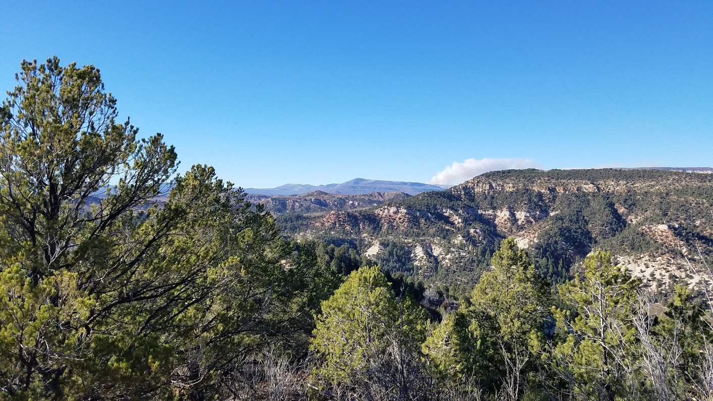 Views from the cross country exit route  Old buildings along the North Fork County Road |
Gear Needed
The required gear for this canyon is a 60 meter rope, harness and rappel device for each person, helmet, and food/water. Summer can be very hot here, while winter can be very cold. Dress accordingly. Bring some extra slings or webbing in case the tree anchors are in need of repair.
Camping/Red Tape
Since this is just outside of Zion National Park, there is no red tape. However if you plan to hike down Orderville Canyon, you will need a canyoneering permit. Dispersed car camping can be found along one of the many dirt roads leading off of the North Fork County Road in the vicinity of Birch Hollow. The best one is a rough spur road that heads left (Northwest) from the road about 0.8 mile north of the trailhead. This is the same road you will use on the return hike I described above.
Map
Birch Hollow Map
External Links
Tom's Birch Hollow Description on CanyoneeringUSA
NPS Description of Birch Hollow