The difficulty of any hike is a subjective point of view. The very first time I heard of Birch Mt - 13,609 ft / 4,148 m elevation) from some hikers descending Split Mt. in 2013, then researching the hike in 2016, I got the feeling that this mountain is difficult and best to be left alone. The only nonbiased matter of fact trip report that I found belongs to Bob Burd. That put me at ease that Birch Mt. can be easily day-hiked. Therefore I decided to follow his route. I found that to be the truth. Birch Mt is a class 2 hike where strength is more needed than skill.
Not only did I want to day-hike Birch, but I had to be at the Inyo Ranger Station in Lone Pine before 4:30 PM to get my blessed Whitney Zone permit for the following day. In that case I had to be back at the car by 3:30PM, at the latest, to I have time to drive to Lone Pine in time to find the ranger station open.
Stats about the hike
I started my hike at 4:55 AM. I did not start at Birch Lake trail head, but rather on Mc Murry Meadow Rd., close to Fuller Creek. I got to the summit at 10:40 AM. I got back to the car at 2:00 PM. A total of 11.15 miles roundtrip, 6 hours and 15 minutes of actual moving time. Average speed 1.6 mph, fastest speed 5.5 mph. Total ascent 5.45 miles and total descent 4.7 miles (coming down I was able to evaluate the shortest route much better.
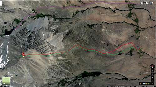
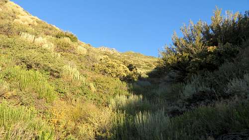
Birch Mountain route
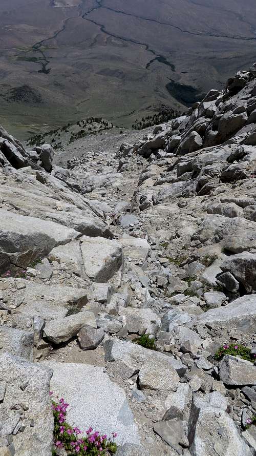
Birch Mountain chute
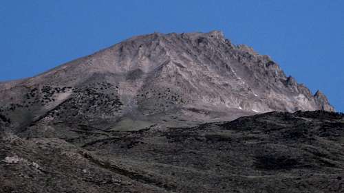
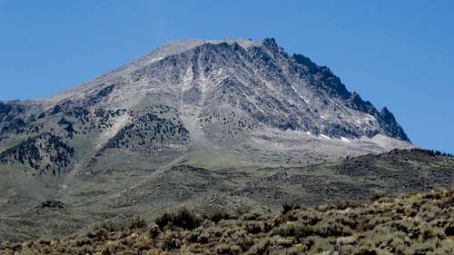
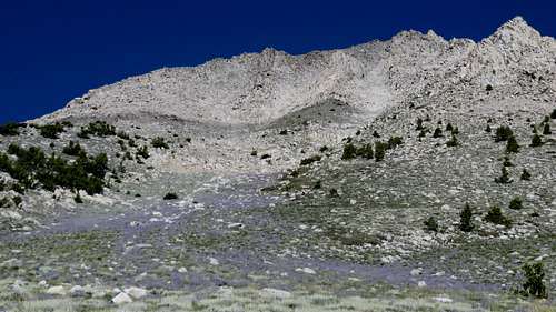
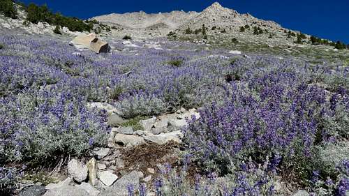
Birch Mountain
In a statement, I can say that for a mountain with virtually no approach (the entire mountain was in front of me the whole time), this felt like, and definitely was, a very long hike. I consider the 9 hours roundtrip a lengthy effort, considering that with a different occasion I needed that much time to roundtrip Mt Whitney. Of course, the route I used on Birch was not the most popular trail to Birch Lake and from there up on one of the chutes. Nor the supposedly easier route on the South Slope (looking down this slope, I don't understand how this is considered an "easier" route since I looked at it in dismay and congratulated myself on not taking it going up.) My route was straight up (and down) from the East. Apparently this East Slope route is shorter by a few miles, but it is all cross-country; what I gained by the shorter distance, I wasted by making my way through the brush. Best of all, this route has no scree. The main reason I decided not to go up via Birch Lake trail was that a few days prior to the hike I stopped the car on I-395 and looked at Birch Mt. From there, the chutes on the North looked full with snow. That deter me from going up that way. In retrospect, I don't know at what chutes I was looking from I-395. Looking down the chutes from the summit, there was no snow on the two chutes I checked out.
Lake next to Birch Lake
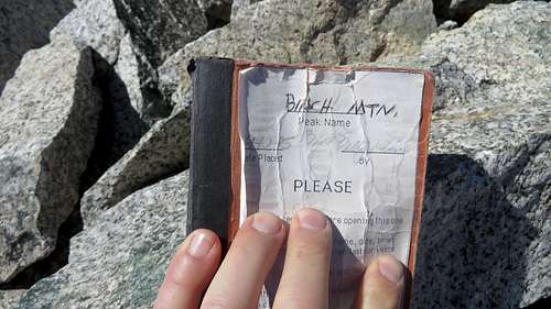
Birch Mountain summit registry
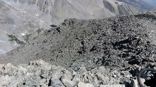
Being on the summit I considered going down via Birch Lake. I don’t know why I decided not do go with that thought, but decided to descend pretty much the way I came. Going down from the summit to Birch Lake would have been probably an hour affair. The one chute I checked out to the North looked fast enough. In truth, I don’t know what would it be, but Birch Mt is 13,609 ft. and Birch Lake is at 10,814 ft. The chute I checked out looked like a nightmare going up on that scree, but going down it did not seem bad.
A summit is a summit
The most unforgettable memory about this hike is the fact that when I got to the summit I was left with less than half a bottle of water:8 oz. And this is where my story really begins. I usually take with me on hikes 3 bottles of water which I refill as I come across sources or water. Knowing that I was going up the Fuller Creek I thought that I’d be in good shape. Little did I know that although going up the Fuller Creek bed is the best way to go up (and that I only found out when coming back down), the creek has no water in it. Absolutely none.
Fuller Creek waterbed looking up
Fuller Creek waterbed looking down
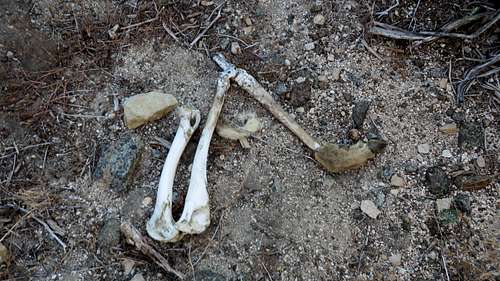
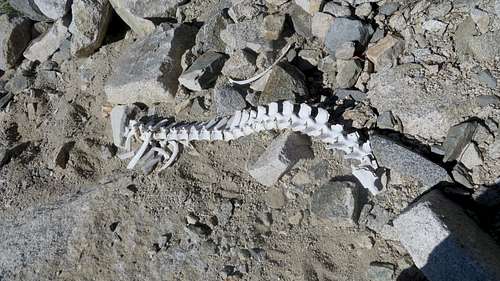
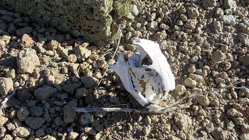
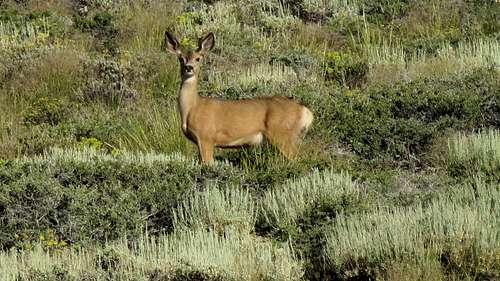
The hike is not technically difficult at all, but it requires a lot of physical resources. It is just as demanding going up as it is coming back down. There is a use trail along the creek bed, most likely made by deer,but the brush requires a lot of zig-zag hiking. When I went up, it was still very early and as the Sun raised I was already in the Fuller Creek waterbed, being shaded by the hill to my right. It was only after I was done with the creek that I started feeling the discomfort of the Sun, around 7 AM. The creek bed was littered with bones of deer, some dry, some still with flesh, cartilage and skin on them. I was wondering if there were coyotes or mountain lions around there to hunt these deer. I got concerned about my safety for a minute there and I started to make some noise once in a while.
Birch Mountain
Birch Mountain
Birch Mountain
I made my way up to the summit, enjoying the chute which is clear of brush and offers a feeling of faster progression. When I gained the plateau, my heart dropped: the summit was now clearly visible and it was on the opposite side of the plateau, another hour to go. But I eventually reached the summit and admired the scenery in a most perfect blue sky, clear and sunny day. I was on the summit probably 15 minutes. While eating an energy bar I walked toward the apparently higher elevation of the summit to the West just to find out that although it appeared higher than the summit where I found the registry, it was not.
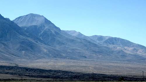
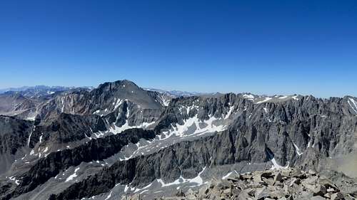
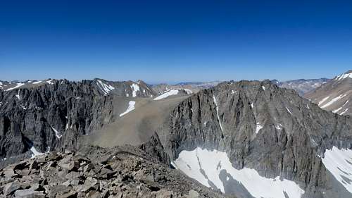
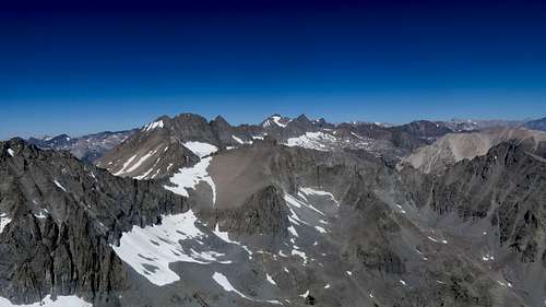
View Sout: Split Mountain, Prater & Bolton Brown
View SW Bolton Brown
From Birch Mt view North
I was done with the summit stuff and I got ready to hike down when I realized that I forgot to sign the registry; I did and I took a picture of it, just to later see that I wrongly wrote the arriving time on the summit by an hour. Well, thank goodness this was not a test.
How one can get in trouble
Starting downhill I knew I only had 8 oz of water left. I also knew that once I cleared the plateau, the temperature was going to raise significantly. That’s why it crossed my mind to go down via Birch Lake: at least that way there was water. But I didn’t. I thought that going down I’d need less water since it was less effort, but I was wrong. I finished the remainder of my water going down the chute. It also got to be 85 degrees, and I only was at the bottom of the mountain. I still had 2 hours to go, and the temperature was getting hotter. Going down the creek bed my mouth was getting dryer and dryer. There was no shade and I was getting alarmed. I did not feel terrible, but I also have no idea what one would feel like to be so dehydrated that it becomes dangerous and by that point I am sure it would be too late. I rearranged the three empty bottles in my backpack so they faced down. That way, whatever waterwas left in them would collect in the caps. From time to time I opened the bottles and drank the little bit of water that accumulated in the caps. That felt good.
Birch Mountain
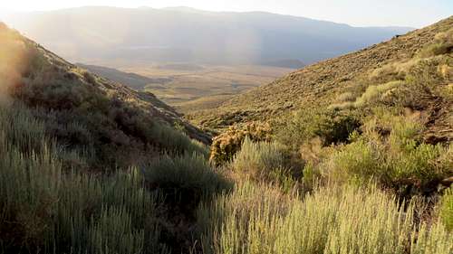
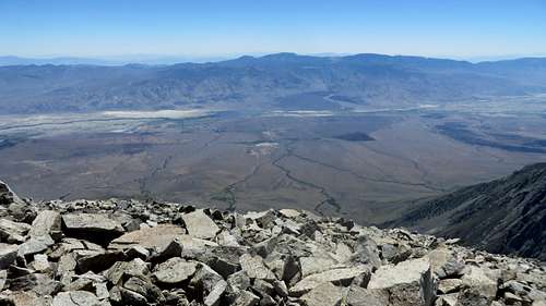
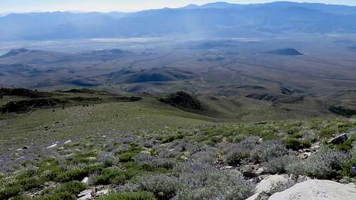
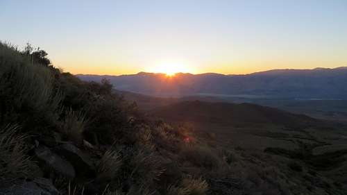
Owen's Valley
Owen's Valley
Half way down the dry creek, I finally saw the vegetation down in the valley. I knew that once I’d get to the green aspen trees, there will be water for me. My speed increased; I was jogging down between the brushes, but the distance to the green trees did not seem to get shorter. It felt like forever until I got to the trees, just to realize that the bushes and all that vegetation were so tangled, there was no way for me to make it to wherever the water was, without a great deal of effort. I quickly determined that the time I’d waste getting to the water was better used getting to the car. I had water in the car.
This low in the valley the temp was over 95 degrees at almost 2 PM. It was hot and ugly. My tong was getting stuck to the top of my mouth. I had no saliva left to wet my lips. I finally made it to a four wheel dirt road and I started running. My last mile to the car I ran. I felt tired but I knew that the action of running was using a different set of muscles, so I ran. I ran for about 9 minutes, spreading fear in all of those deer, poor cows and bulls that were grazingon that soggy valley, causing them to run every each way just to get away from me. I made it to the car and grabbed a bottle of water. In the car must have been 120 degrees, and the water was as warm as tea, but at that point it did not matter: it was all I needed.
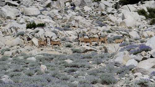
Deer on Birch Mountain
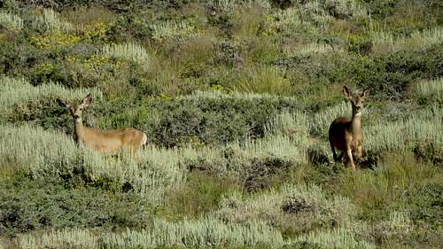
Deer on Birch Mountain
Deer on Birch Mountain
Ridiculous training paid off
To anyone that made it this far reading my TR, I have to point one thing out. It is important to not judge me too badly for the stupidity of not planning better to be secured with enough water for this hike. In Ohio, I don’t have too many options when it comes to training for hiking. Where I live, the land is mostly flat, with no mountains and barely some hills.The preferred method of training is long distance running. I don’t like running much, but to me it is a means of conditioning my body for hiking. My runs last mostly 2 - 2.5 hours of uninterrupted running, during which time I don’t drink or eat anything. I try to do my running thru the hottest part of the day. During that time I usually runt 16 or so miles. I purposely train like that, to condition my body to function in delicate situations. I never thought I'd be in a delicate situation, but if I was, I wanted to be prepared. I’ve been training like this for more than 4 years. I am sure that this ridiculous training of mine paid off during this particular hike and it was actually what helped me to finish on my own feet, avoiding a tragedy. In addition, my yearly trail run at the Grand Canyon had me in the know as far as moving in direct Sun for a long time. But then, I am probably making too big of a deal about this; what mountaineer hiked all of his/her life without ever running into a dificult situation. Running into trouble is not a big deal; finding the right solution to a trouble is what makes the difference. This time I had the solution before even needing it. We live and we learn.
That's a good speed. I did it a couple of days later using the Birch Lake route and it was 5 miles and 3 hours longer. And terribly loose (but no snow on the NW chute) so you got the better deal.
Thank you for the note. My route 5 miles shorter? That's a big diffrence. I should write a route description for the East Slope. I didn't realize that the NW climb was such a pain until I saw the chutes with my own eyes. Lucky for me, as nasty as it was to hike between the brush and absolutely no shade the entire day, at least I didn’t have scree.
Parents refers to a larger category under which an object falls. For example, theAconcagua mountain page has the 'Aconcagua Group' and the 'Seven Summits' asparents and is a parent itself to many routes, photos, and Trip Reports.


Comments
Post a Comment