
|
|
Route |
|---|---|
|
|
42.46437°N / 13.56297°E |
|
|
Mountaineering |
|
|
Winter |
|
|
Most of a day |
|
|
F |
|
|
Overview
Bissolati Couloir was first climbed 6th of march 1911 by Leonida Bissolati, Giovanni Lorenzoni and Francesco Acitelli.It’s a wide couloir descending from the west ridge of Vetta Occidentale, about 50 meters from the top. This couloir is the easiest of the south-side couloirs and the better way to descend from Corno Grande when the mountain is covered in snow. In summer it’s covered by gravels and therefore uncomfortable: it’s better to climb or descend from the normal route (easy, but the longer way) or from Direttissima (some passages of II UIAA, the shorter way).
Best season to climb: late winter-early spring.
It was first descended in ski from the strong mountaineer Domenico “Mimì” Alessandri from L’Aquila. Today Canalone Bissolati had became a classical of ski-touring in Gran Sasso range, but only for very skilled skier! Difficult: OSA (scale Blachère).

Approach
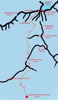
1) follow the path that reaches the pass of Sella di Monte Aquila (2335 m), crossing at half coast the slopes of Monte Portella.
2) If there's no track or there are big snow-ledge it’s better to climb to Duca degli Abruzzi Hut and then, along the edge, reach Sella di Monte Aquila.
From there, follow the path towards Sella del Brecciaio until you get the start of Bissolati Couloir (about 2500 m; 1:45-3:00 hours depending on snow conditions).
Downhill: from the summit of Vetta Occidentale take the west ridge and walk down until you meet, on your left (south) the first wide couloir descending toward Campo Pericoli (about 50 meters from the top).
Route Description
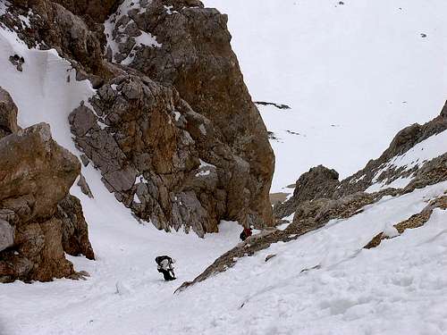
The couloir, in the higer part, is quite wide and not so steep (about 30°-35°), but sometimes icy. Further, a couple of narrows are the hardest part: there the slope steepens (about 40°) for few meters and the way is quite tight. Last difficulty at the exit of couloir: with few snow, you must pass trough many emerging rocks and a fall there, with icy snow, could be very dangerous.
Finally, it’s an easy route but don’t underestimate it: it could be very risky...

Essential Gear
Ice-axe, crampons, helmet.Literature, maps, external links
- Cai-Tci Guide "Gran Sasso d'Italia", L. Grazzini, P. Abbate.The best map, scale 1:25000, is "Gran Sasso d'Italia" edited by Cai-L'Aquila
- For weather report and avalanche bulletin: Bollettino Meteonivologico Meteomont - Appennino centrale