
|
|
Route |
|---|---|
|
|
39.06917°N / 106.4338°W |
|
|
Hiking |
|
|
Spring, Summer, Fall |
|
|
Most of a day |
|
|
2 |
|
|
Overview
Black Cloud Trail is not one of the Primary Routes on Mt Elbert. It is an alternate route that approaches from the south on the western side of Mount Elbert. This route is far less traveled by and, even in the busy summer months, can be traveled without coming across any other hikers (at least until you reach the summit of Mount Elbert!) It also passes over the summit of South Elbert (although it does not meet the 300 ft prominence requirement to be considered its own mountain it DOES have its own marker and a register that you can sign). On the trail up you will find stunning views to the south of La Plata. This trail is considered a much more scenic trail than the two Primary Routes but also much more difficult.
Getting There
From Leadville, Head South on U.S. 24 to the intersection of CO 82. Make a right, heading west on CO 82 for exactly 10.5 miles to a right turn (north) to the signed trailhead. The trailhead can be difficult to spot. Make sure to pay attention to your mileage from the U.S. 24/CO 82 intersection. If you reach The Mt Elbert Lodge on the left and cabins on the right you have passed the trailhead and have to turn around. There is a SMALL sign marking the turn-off and a small dirt parking lot. (The GPS coordinates of the trailhead are: 39.06888, -106.43368)
Route Description
This trail begins 9700 feet above sea level and immediately, but gradually makes it way up into the woods. During the first section of the trail it follows along Black Cloud Creek and is mostly wooded. There are a few vistas as the trail climbs higher, looking back towards the south you will find stunning views of La Plata across the the valley. You will cross over a stream a few times before reaching some very steep parts and then entering a small aspen glen. After a little more than 1.5 miles and 1700 feet vertical gain the trail emerges from the trees and cross over a boulder field before reentering a small grouping of trees. At about 11,688 ft the trail passes an old burnt down cabin and outhouse. If you are planning on overnighting for this trip this is a great place to set up camp. It is about a third of the way up the trail and there is a bit of flat land to set up camp. Just past this site you catch your first clear glimpses of South Elbert. The trail crosses back and forth across the boulder field a couple times before getting completely above treeline. There are a number of switchbacks on this part of the trail but stunning views of the surrounding Rockies. At about 2.7 miles into the trail it gains the ridge line and heads north towards South Elbert. After summiting South Elbert the trail descends about 200 feet to 13,940 ft before the final approach up Mount Elbert. This is a moderately strenuous hike and can take as many as 6 hours to summit. Departure time should be planned accordingly.
When To Climb
June through September is considered the summer climbing season. Mt. Elbert is also climbed in the dead of winter by experienced mountaineers, however it is recommended to use the South Mt. Elbert Trail and the North Mt. Elbert Trail for winter ascents. Summer hikers are encouraged to start hikes early (even pre-dawn) as thunderstorms are a daily occurrence and they should plan to be off the summit or ridges by early afternoon to avoid lightning danger. Start very early and allow 8+ hours for climb and descent.
Maps
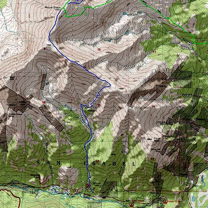
Black Cloud Trail marked in Blue
Essential Gear
Standard day hike gear: a good pair of hiking boots/shoes, synthetic clothing in layers, lots of water, snacks, sunscreen, rain gear, and your camera!
Red Tape
No permits or fees are required to park, climb, or hike.
Mt. Elbert is located in the Leadville Ranger District of the San Isabel National Forest.
Leadville Ranger District, San Isabel National Forest, 2013 N. Poplar, Leadville, CO 80461 Phone: (719) 486-0749 Fax: (719) 486-0928.
MarkDidier - Jan 15, 2014 8:52 pm - Voted 9/10
Additional InfoPer Roach - SE Ridge, YDS Class 2, 10.0 Miles Roundtrip, 5,250 feet of elevation gain.