
|
|
Area/Range |
|---|---|
|
|
46.98734°N / 123.14078°W |
|
|
Hiking |
|
|
Spring, Summer, Fall, Winter |
|
|
2660 ft / 811 m |
|
|
Overview
The Black Hills of the State of Washington are a group of low-elevation peaks south of Puget Sound, in both Thurston County and Grays Harbor County, away from the higher and more well-known Olympics and Cascades mountain ranges. The Black Hills are located several miles southwest of the city of Olympia, the State Capitol. In fact, the Black Hills are part of the Capitol State Forest, a forest so-named because of its close proximity to the State Capitol.None of the peaks within the Black Hills have an elevation over 2700'. Although that is considered low in relation to other Washington peaks, it should be recognized that Thurston County only has two other peaks with elevations over 2700' and neither of those peaks have elevations over 3000'. Some of the higher peaks within Thurston County, including the three of the five tallest, are located in the Black Hills. Hence, it could be argued that the Black Hills have some of the best peakbagging that Thurston County has to offer.
The Black Hills range likely gets its nameright from its occasional dark appearance from afar, especially as seen from Olympia and the I-5 corridor. The Black Hills and Capitol State Forest both cover nearly the same amount of land area, and are commonly linked together in general descriptions of the region. From the Black Hills, many notable points of interest can be seen, including the Pacific Ocean, Olympics mountain range, Puget Sound, Olympia, and Cascades mountain range (including Mount Rainier, Mount Adams, and Mount Saint Helens).
 Western Side Of Black Hills Range
Although all mountains and hills within the Black Hills are considered low-elevation, especially by comparison with many other Washington peaks, there are several notable and significant peaks within the area. First and foremost, located in the center of the area is Larch Mountain, which at 2660' of overall elevation and 2316' of prominence is both the highest and the most prominent peak within the Black Hills. In addition, of all inland Washington peaks with at least 2000' of prominence, Larch Mountain has the lowest elevation, as well as the third-lowest elevation out of the ~1200 peaks with at least 2000' of prominence that are located in the western contiguous United States.
 Larch Mountain
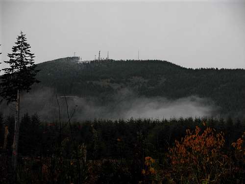
Another notable peak within the Black Hills is Larch Mountain's neighbor, Capitol Peak. The mountain is slightly shorter than Larch Mountain by only approximately 1' in elevation, but with only 433' of prominence is considerably less prominent then Larch Mountain. Despite these facts, Capitol Peak is possibly the most recognizable and most visited mountain within the Black Hills. This is because the top of Capitol Peak has long-since been clearcut to allow room for numerous communications towers, which can be seen from many miles away from the area. With no other major peaks obstructing views, the summit of Capitol Peak proved to be ideal location first for fire lookouts and then later for communications towers.
 Capitol Peak
Other notable peaks within the Black Hills include Rock Candy Mountain, Little Larch Mountain, Mount Molly, and Fuzzy Top. For many years it was widely believed that the highest peaks in Thurston County were actually within the Black Hills, before several geological surveys proved otherwise. In reality, the Black Hills have the third-highest, fourth-highest, and fifth-highest peaks (Larch Mountain, Capitol Peak, and Rock Candy Mountain, respectively) in Thurston County, behind only Quiemuth Peak and Clam Mountain (both located on the east side of the county).
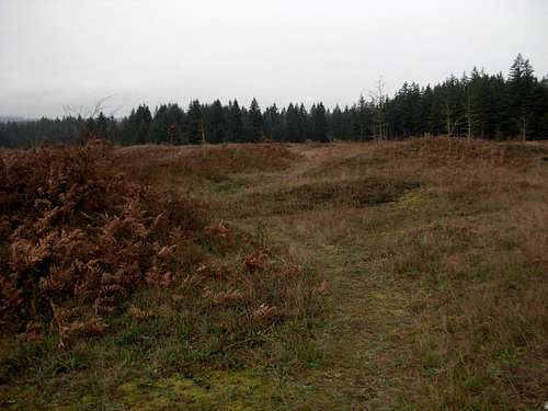
 Fuzzy Top
The Black Hills and Capitol State Forest are the most hiked and climbed areas of Thurston County. A wide variety of recreational uses include hiking, biking, snowshoeing, horseback riding, quad riding, snowmobiling, motorcycling, and hunting. Unfortunately, despite the high amount of visitors and usage, the Black Hills is considered by many to be a bit of an eyesore, as every major peak has succumbed to clearcut logging... some peaks definitely more frequently and extensively than other peaks. No old-growth forests exist in the region, and what forests do exist typically are fairly young (i.e. less than 30 years old). Logging is a very important industry for the region, and the Black Hills have an abundance of trees to provide for that industry.
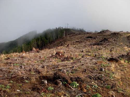 Clearcut Slopes On Larch Mountain
The Black Hills are also home to a geological oddity known as Mima mounds. Named after the Mimi Prairie on which they are located, on the eastern lowlands of the Black Hills, Mima mounds are numerous rounded piles of soil approximately 3-9' tall scattered throughout the prairie landscape. The true cause of these unusual formations is unknown and widely disputed. Mima mounds are most notably found in Washington and six other States (California, Idaho, Wyoming, Texas, Arkansas, Louisiana), as well as Canada, Mexico, China, Kenya, and Argentina. Due to its geological and historical significance, the Mima Mounds Natural Area Preserve (MMNAP) is designated as a registered natural landmark and located on the southeastern side of the Black Hills. None of the mounds are tall enough to truly "summit" like a mountain, but an interpretive trail is found within the MMNAP to see these odd structures.
 Mima Mounds
Getting There
Directions to the eastern entrance ("Delphi Entrance", the most popular entrance of Capitol State Forest), as if coming from Olympia, WA:
1) From the intersection with I-5, head west on U.S. Highway 101.
2) Within a couple of miles, take the second exit along Highway 101, the "Black Lake Blvd" exit.
3) Turn left onto Black Lake Blvd (lighted intersection).
4) Drive south along Black Lake Blvd for 4.2 miles, until a stop sign (Delphi Road).
5) Turn left onto Delphi Road and follow for 2.1 miles.
6) Turn right onto Waddell Creek Road.
7) After 2.7 miles, Waddell Creek Road turns left. Do not turn. Continue straight, and the road is Sherman Valley Road.
8) After 1.3 miles, Sherman Valley Road technically ends and the "C-Line" Forest Road of Capitol State Forest begins. There is a "Leaving Public Road System" sign near this location.
------------
Other entrances to the area include:
NORTH: "Rock Candy Entrance"
WEST: "Porter Creek Entrance"
SOUTHWEST: "Cedar Creek Entrance"
SOUTHEAST: "Bordeaux Entrance"
EAST-CENTRAL: "Waddell Creek Entrance"
Red Tape
Beginning during 2011, parking areas and trailheads within and for the Capitol State Forest require a Discover Pass to be in each vehicle during the visit. Failure to have a Discover Pass visible within a parked vehicle at these locations can result in a substantial fine. For more information regarding the Discover Pass, please visit the official website.Public access to the Black Hills/ Capitol State Forest is allowed year-round. However, there are specific rules and regulations regarding trail access and hunting (see notes below).
Trails within Capitol State Forest, including those on and around Larch Mountain, are closed to motorized and equestrian uses between May 1 - November 30.
Hunting is allowed within Capitol State Forest. Please take necessary precautions (such as wearing bright colors) during hunting season. Please contact the Washington State DNR for updated hunting information.