
|
|
Mountain/Rock |
|---|---|
|
|
44.07390°N / 71.92°W |
|
|
2830 ft / 863 m |
|
|
Overview
 Black Mountain from Mount Mooselauke
Black Mountain is among the many smaller yet attractive mountains to climb in New Hampshire. It is well known for being a great family hike with distances on both the Black Mountain Trail and the Chippewa Trail being very moderate compared to many of the other White Mountains. Out of the two trails the Black Mountain is the easier trail while the Chippewa Trail is a steeper but more scenic trail. The summit has absolutely gorgeous views of Mt. Mooselauke and Mt. Kinsman in the East and the Upper Connecticut River Valley and the town of Woodsville in the West.
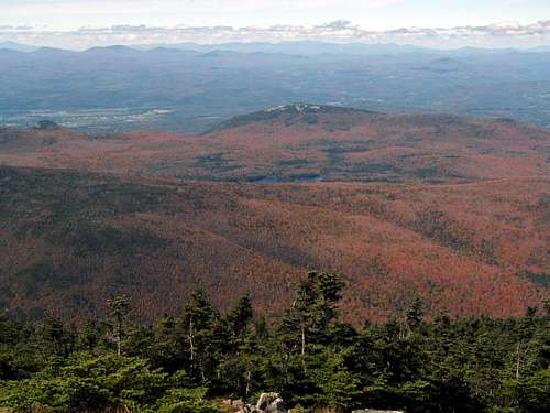
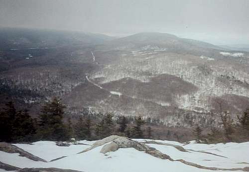 Views from Black Mountain
Though Black Mountain is a mountain with great views from the top and is easy to ascend, it is not as popular has many of the other White Mountains due to it's lack of height and it accessibility. In fall and winter Black Mountain is a great mountain if you are interested in have the whole mountain to yourself.
 |
Getting There
VIA BLACK MOUNTAIN TRAIL (1630'): From I-93 get off on Exit 32. When you hit the light on the ramp make a right on 112 (West) and head towards Woodstock. Go through Woodstock and set of light and stay on 112 heading west towards Woodsville. Stay on 112 past junction with 118 and past junction with 116 North toward Franconia. Keep on 112 until you reach 116 south towards Benton. Stay on 116 thru Benton. When you hit a fork on the road, stay left. Make an immediate left on Howe Hill Road. Take Howe Hill Road until it becomes a gravel road. Parking will be on your right just before the 2.3 mile post sign. (Note: the White Mountain book list the trail as 1.7 miles on the gravel road, but due to poor conditions of the road parking here and hike the extra 0.6 miles is well advised.)
VIA CHIPPEWA TRAIL (1320'):From I-93 get off on Exit 32. When you hit the light on the ramp make a right on 112 (West) and head towards Woodstock. Go through Woodstock and set of light and stay on 112 heading west towards Woodsville. Stay on 112 past junction with 118 and past junction with 116 North toward Franconia. Keep on 112 until you reach 116 south towards Benton. Stay on 116 thru Benton. When you hit a fork on the road, stay left. down roughly four mile make a left on Lime Kiln Rd. and the trailhead will be roughly two miles on your left.
Red Tape
No mandatory fees (yet!!!!)
When To Climb
Black Mountain can be climbed at anytime, with exception to mud season (April and early May) due to trail erosion. Snowshoes are highly recommended on both trails during winter. The Black Mountain Trailhead though starts even further back in the winter due to part of the road not being maintained in winter. Still the trail is at most 5.5 miles even with the additional unmaintained road section and is still very easy to ascend in winter.
Camping
Black Mountain at any time can be done in a day. However if you are interested in camping on Black Mtn. refer to the Backcountry Camping Rules in the AMC White Mountain Guide (see BOOKS)
Mountain Conditions
Here are two websites that will provided you the best information on conditions in the White Mountains.
Appalachian Mountain Club
Current Trail Conditions
Summit Picture Log
Post your summit mugshot here.
EastKing - Sep 24, 2005 4:03 pm - Hasn't voted
Untitled CommentThanks for the input. I updated the page's overview so the trail doesn't surprise people.
STW - Sep 23, 2005 5:05 pm - Hasn't voted
Untitled CommentI love Black Mt (Benton Range), and have climbed it many times in many conditions. I would point out that it is not actually the easiest climb in the book. The middle third of the Chippewa trail is actually quite steep. It's not very long, but it can be pretty tough for newbies or people who are not in good condition.
EastKing - Sep 24, 2005 4:03 pm - Hasn't voted
Untitled CommentThanks for the input. I updated the page's overview so the trail doesn't surprise people.
royswkr - Jan 7, 2006 10:09 am - Hasn't voted
Untitled CommentThe village you pass through in both sets of directions is actually "North Woodstock", if you get to Woodstock you are lost :-)
I would suggest reaching the Chippewa Trail at least via Rte.25 if you are coming through Plymouth
Hebroned - Feb 5, 2020 7:35 am - Voted 10/10
Chippewa Trail is SteepThe Chippewa Trail has over a 1,500' elevation gain in 1.8 miles. This is considered a steep and difficult climb by most day hiking standards. It is family friendly because it is a short (1.5 hr. book time) to the top with outstanding 360 degree views of the Connecticut River Valley and Green Mountains of Vermont to the east and south, The Presidential and Franconia range to the north and Mt. Moosilauke to the east.