
|
|
Mountain/Rock |
|---|---|
|
|
44.71070°N / 111.4144°W |
|
|
Fremont/Madison |
|
|
Hiking, Mixed, Scrambling |
|
|
Summer, Fall |
|
|
10237 ft / 3120 m |
|
|
Overview
 Black Mountain from Targhee Pass
 Black Mt. and west ridge
 The summit
 Near the summit
 Northeast aspect
 The north ridge
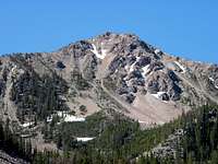 End of west ridge
Not to be confused with the hundreds of other Black Mountains out there, this one is higher than most at 10,237 feet and anchors the southwest corner of the Henry’s Lake Mountains on the Idaho/Montana border a few miles west of Yellowstone National Park. It is situated on the Continental Divide abruptly rises 3,765 feet above Henry’s Lake and it the fourth highest summit in the small, but beautiful Henry’s Lake Mountains. It has 897 feet of prominence.
The mountain is a general pyramid with three close summit points. The main ridges run northwest, southeast and northeast, perpendicular to the first two. The northerly ridges are part of the Continental Divide. The south aspect is broad and steep with some relatively small, yet sharp and steep ravines. This slope is covered with tangled shrubs and trees on very rotten rock. Various maps show two trails coming up this slope, but they likely are no longer in use or present. The northeast bowl is a series of shelves below steep slopes supporting large talus runs, subalpine forests and marshes and ponds. The northwest bowl is very steep and holds substantial snow well into summer. The best way to climb this mountain is along the base of the northeast running ridge. Refer to the Route Overview section for a better discussion of travel on the mountain.
This mountain can be done in a day hike by a strong hiker who has a good plan and gets an early start. From the trailhead it is about a fifteen mile round trip to the summit and back. It might be best to camp or make it an extended hike and spend some time on the other summits of this small, but interesting mountain group. This is a grizzly bear area so take pepper spray, make noise, have a clean camp and take some friends who you can outrun.
Getting There
 Black Mountain and its north ridge
The area can be entered via the Mile Creek Trail (004) from the Montana side or from the Targhee Creek Trail (27) on the Idaho side. The Targhee National Forest does a great job of providing access and trail info from the Idaho side on the internet, but the Beaverhead NF does a terrible job for the Montana side. Fortunately the best way from the Montana side is provided for you here.
 Junction trails 27/004
 Below 27/004 junction
 Northeast flats
 Upper northeast face route
 Mile Creek
 Lower Mile Creek trail
 Upper northeast slope
 East side north ridge
Mile Creek Trail
If coming on Highway 20 from the south, drive 42 miles north from Ashton to the junction with Highway 87. Turn left (west) on Highway 87 drive nine miles to the Idaho/Montana State line. Continue north on the same highway for approximately 3.6 more miles to the Mile Creek Road. This is marked by a small roadside sign that looks like its pointing into the driveway of a large house close to the highway. Take it and the road will almost immediately turn away from the house and head for the mountains. From the turnoff from Highway 87, its one mile to the trailhead. There is a stream to cross immediately before the trailhead, but the bottom is a hardened crossing so it should be no problem for most vehicles. If unsure there is room to park west of the creek and cross on foot. The total distance from Highway 20 to the trailhead is almost 14 miles.
To reach the trailhead from the north take Highway 287 south from Ennis, Montana for 40 miles, then turn right (south) on Highway 87 and go five miles south to the Mile Creek turnoff by the large house mentioned above. If coming from the east, go 13 miles from West Yellowstone over Targhee Pass to the junction of Highway 20 mentioned above. Follow the directions from there.
The Mile Creek Trail is not as indicated on USGS quad maps. The first two or three miles is the same, but new construction takes the trail on a series of long switchbacks and reaches the top of the Continental Divide further south than indicated on the quad maps. The trail is obvious and there is no way to get lost on the old trail. From the trailhead follow the path south up the Mile Creek basin for approximately six miles to the junction with the Targhee Creek Trail (27) on the Continental divide separating the Targhee Creek and Mile Creek basins. Turn right Trail 27 for a very short distance down to the north end of the gentle basins at the northeast foot of the peak. Once in this basin follow the suggested path found in the second paragraph of the Route Overview section.
Targhee Creek Trail
To reach the Targhee Creek Trailhead go 15 miles north of the Island Park Ranger Station on Highway 20 to Forest Road 57 and follow it a short distance where it ends at the trailhead. The turnoff for road 57 is about 10 miles west of West Yellowstone. The Targhee Creek Trail with a 1.5 miles portion of the Continental Divide trail makes a 15 mile loop through the heart of the Henry’s Lake Mountains. To reach Black Mountain take the west branch of the loop into the Dry Fork drainage, then into the headwaters of the West Fork of Targhee Creek. It’s approximately five or six miles to the basin at the northeast foot of Black Mountain. Once in this basin follow the suggested path found in the second paragraph of the next section.
Route Overview
 Mile Creek
 Upper northeast flats
 From the 27 trail north
This mountain is fairly crumbly and possesses often steep and difficult slopes. Still it is a good scramble for people of no special abilities if they are careful and plan well. Climbing the mountain from the south would be very difficult due to the long steep slope composed of often loose material covered by tangled shrubs and trees. The northwest ridge or north bowl from the north is also an option, but getting up to this ridge from the Mile Creek Trail below would be difficult. Also the north bowl is made up of very steep suspect rock that is often locked in snow. The northeast ridge may look inviting on the map but its very dangerous and would be a very difficult time. By far the most practical and safe way to this summit is on the east or northeast aspects via the east base of the northeast running ridge.
Once the northeast basin is reached from either the Montana or Idaho side as described in the previous section, there is not any particular way one has to go. On the flats just below the Continental Divide, leave the trail and head south to southwest. There are several small flats and basins to cross. It is possible to go on the talus immediately below the ridge, but hopping these rocks takes more time. Getting too far to the east and the up and downs of the drainages can take some time. Pick your way finding a happy medium to the large flat with a pond at the immediate southeast foot of the summit cone. From here it is possible to take a number of small runs through the solid rock and cliffs to the summit area. Or continue south to the end of the flat and work around the subtle aspect change to the more east-facing slope. Then take a less steep run up through the stunted trees to the top. The footing with the former summit option is difficult due to scree and loose gravel and soil. The second route is easier, but may take a bit longer.
A nice return option from the summit would be to hike down the northwest ridge to the west ridge points that are also over 10,000 feet, the drop off for a long descent back to the Mile Creek Trail. Just be sure to have a topo map to find the easier, more open slopes and allow yourself plenty of time. From the northeast basin over the mountain and down into Mile Creek there will be no water except for snow, which may not be present late in the summer.
Red Tape
Generally none. The area is not designated wilderness, though it is largely managed as such. In the core travel areas travel is limited to hikers and horses. Other areas allow bikes, but all areas are non-motorized. The Targhee National Forest provides an excellent travel planning map online for access from the Idaho side. It is assumed management for the Montana side is similar, but that information is not as readily available. If it matters use the Beaverhead-Deer Lodge contact information provided below.Camping
 Flats below Black Mountain
 Flats at northeast base
 Pond east of summit
Camping is limited close to Black Mountain. The best option would be the north end of the flats at the northeast foot of the mountain. To reach these hike the six miles to the divide, then take the trail south for a very short distance. This area is very accessible to the main trail, has many camping spots and most of the year water is available. It is also possible to pack further to the south closer to the mountain to find the perfect flat or meadow to camp in. Other than this area one would have to continue on the trail north of the divide to the Targhee Pass area before any other good options are found. This is about two miles further north from Black Mountain.
When To Climb
The snow is still heavy well into June most years, but by the start of July enough of the trails and slopes are open to provide good access. The north slopes may hold their snow well into summer however. The mountain can be reached in winter by the hard core, but all slopes would be prone to avalanches and access would be long, difficult and dangerous.Mountain Conditions and Information
 The north bowl of Black Mountain
Go to the mountain prepared for variable conditions. A summer a day that starts out nice and clear often will see thunderstorms move into the mountains bringing rain, cold and lightning. Check the forecast closely and be prepared.
For specific information contact the Island Park Ranger District of the Targhee National Forest. An access map on this Forest’s web page makes planning easy.
Island Park Ranger District
Targhee National Forest
3726 Highway 20
Island Park, Idaho 83429
(208) 558-7301
For the Montana side this area is part of the Madison Ranger District of the Beaverhead-Deer Lodge National Forest.
Madison Ranger Station
5 Forest Service Road
Ennis, MT 59729
Phone: (406) 682-4253
NOAA Forecast