
-
 8861 Hits
-
 78.27% Score
-
 9 Votes
|
|
Route |
|---|---|
|
|
40.82350°N / 111.7408°W |
|
|
Hiking, Skiing |
|
|
Most of a day |
|
|
Class 2 |
|
|
Overview
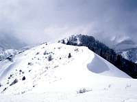
 Ridge in the snow mist
West Ridge of Lookout Peak, a.k.a. Black Mountain Ridge, is a moderate to long hiking / skiing routes which affords a traveller more picturesque terrain than on the standart dry and brushy Birch Spring Pass route. There are numerous variations on the theme, all of which converge at the 8,300 ft base of the West Shoulder.
Getting There
Black Mountain Ridge can be followed all the way East from Black Mountain summit (accessible from Dry Creek of the N edge of the U campus, from Twin Peaks trailheads in the Federal Heights and Avenues, or over the ridge of Mt. Van Cott). The ridgeline jeep trail, as shown on the topos, deteriorates into oblivion after climbing from the Avenue Twin Peaks to Black Mountian. A more prominent trail drops into City Creek into the vicinity of Rotary Park, almost 5 miles short of Lookout Peak, instead of following the ridge further East.There are numerous shortcuts which would place one on the West Ridge of Lookout Peak closer to the summit.
From City Creek, one could follow the main trail to a prominent tributary flowing from the South-East about a mile upstream of Cottonwood Gulch. There is a trail up this side drainage, albeit even less distinct at first than the City Creek trail. If you miss the junction, it is easy to locate the trail at the first meadow, a couple hundred yards up the drainage. It crosses from one bank to another numerous times, and is generally easier to follow further upstream.
 Freeze Creek
From Emigration Canyon side, there are good trails up Freeze and Brigham Creeks, or one could ascend directly from the Pinecrest Road. This is the side of Emigration Canyon where the homeowners have fought vigorously to prevent trail construction - and they won in the end, leaving a kind of a rump trail system to the NE of Emigration Oaks subdivision, lacking connecting trails to the West.
Freeze Creek trail used to start off the cul-de-sac at Emigration Estates Ct but it looks like new construction has blocked this path, and now most people just follow the creekside trail off Pioneer Fork Road, adding perhaps a quarter mile to the route. The trailhead is prominent posted No Tresspassing, but foot / snowshoe traffic there is unmistakeable and on the weekends, there are usually hikers' cars parked right by the sign.
Brigham Fork has the so-called Old Mine Road, actually a historical RR grade, a spur of the former Emigration Canyon Electric Railway, extending from Pinecrest to the former mine tunnel. One can get to Old Mine Road from Burr Fork in Pinecrest (if lucky to be able to park there) or from the bottom of Emigration Canyon. The new trail system also connects lower Brigham Fork, near Pioneer Fork Road, with the water tank on the ridge separating it from Burr Fork, accessing the RR grade. But at a first glance, the trail, with a nice footbridge crossing Brigham Creek here, is entirely blocked from the public behind a million-dollar wrought-iron security gate. There is probably an official workaround but as of this moment, I don't know how to locate it.
Unlike the lower-elevation Freeze and Brigham Fk trailheads (about 6,000 ft), the end of Pinecrest Road in Burr Fork is at 6,850 ft elevation. But you can forget it about parking there.
Route Description
 West Shoulder
Freeze Creek trail follows the West fork of the creek to a saddle overlooking Red Butte Preserve, and continues East along the ridge separating Freeze Creek from Red Butte Creek / Pine Fork. Beyond the next saddle, the trail grows much fainter. Nothing to worry, it's only a couple hundred yards to the hairpin turn of an abandoned fire road - just head to the group of firs straight ahead and you will intersect the road.
The overgrown former road gains altitude steadily, passing a saddle where it connects with Brigham Fork trail, crossing into Knowlton Fork, and climbing steeply to Black Mountain ridge just North of Hill 8,326. The undulating ridge is narrow here, with a spiky rock blocking direct access to the East, but it becomes much wider soon. One would have to drop about 400 ft to the saddle in the head of Burr Fork, then regain about a 1000 ft, over a prominent red sandstone West Shoulder, to the peak proper.