

-
 33379 Hits
-
 86.54% Score
-
 23 Votes
|
|
Area/Range |
|---|---|
|
|
35.76470°N / 82.2653°W |
|
|
Hiking |
|
|
Spring, Summer, Fall, Winter |
|
|
Black Mountains Overview.
The Black Mountains are the highest range of peaks in the eastern USA. Several of the summits reach or exceed 6,600 feet in elevation and loom as high as 4,000 feet above the surrounding terrain.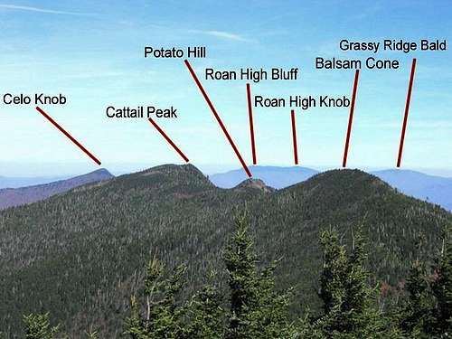 Significant points along and viewed from the Black Mountain Crest Trail.
Named for the dark cover of spruce and Fraser firs that blanket these high mountains, they do indeed appear black from a distance. The forests here were leveled in huge timber operations that lasted from the late 1800s until about 1930. Almost every peak and cove in the Black Mountains was denuded of forest cover as the virgin forests were felled and the lumber carried off to markets.
Over the course of the following century the balsam forests recovered and peaks once again took on their characteristic dark appearance. However, beginning in the 1970s, the twin effects of acid rain the introduction of the invasive insect, the balsam wooly adelgid, caused the mature forests of the upper ridges to succumb and die off in a terrifyingly short amount of time. As recently as the late 1980s, the Black Mountain ridges were more likely to display dead bare trunks of the old trees than healthy growth.

However, in the past few years the understory of immature Fraser firs has begun to grow high enough so that one once again walks in shade along the trails. Time will tell if the threats of pest and industrial pollution will allow these trees to fully recover.
A large portion of the Black Mountains is protected in some form of land trust or another. The Mount Mitchell State Park preserves about 1800 acres along the very highest mountain crests, and the Pisgah National Forest gives some measure of protection to the northern end of the range leading down beyond Celo Knob toward the lowlands to Bolens Creek. Farther south, the Blue Ridge Parkway corridor also keeps some of the higher Black Mountain peaks from commercial development. However, there is constant pressure all around the base of this range and onto the slopes. Urban sprawl threatens this very fragile environment, and most of the peaks are easily accessed from roadways that thread throughout the range.
The highest peak in the Black Mountains (and thus, the eastern USA) is Mount Mitchell at 6,684 feet. Nearby, Mount Craig rises to 6,648 feet. Several other peaks both to the north and south of Mitchell exceed 6,500 feet in elevation. A number of trails allow foot travel to almost all of the highest peaks, with only a few accessible via manways or bushwhacks. The most well known trail in the area is The Black Mountain Crest Trail, which stretches from Mount Mitchell at its southern terminus to Bolens Creek at the foot of Celo Knob at the northern end. It is known as one of the most difficult trails on the east coast and deserves its reputation.
When hiking in the Blacks, one should never expect clear weather. It’s a rare day that affords the hiker unobstructed views from the highest peaks (or of them). The almost constant cloud cover is one reason that the effects of acid rain was so devastating for these mountains all during the years from the 1970s until the 1990s. In winter months the conditions in this range can be quite severe—with sub-zero temperatures, very heavy snow, and hurricane-force winds. In warmer months, one must be wary of thunderstorms that often rake the upper reaches of the Blacks.
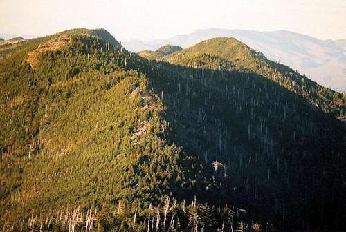
 Black Mountains from Mount Craig (looking south).
Because these peaks are considered the highest in eastern America, some sites and points of interest can become crowded, especially during the summer months. However, it is quite easy to find solitude here. One can merely hike along one of the trails that plunge into the forests and leave the crowds far behind. There are a number of fine semi-developed campgrounds in the area, including Carolina Hemlock, Black Mountain, and Mount Mitchell State Park. The coves and valleys harbor cold, clear streams full of native brook trout; and the forests are home to a sizable deer herd and one of the heaviest concentrations of black bears in the South.
In addition, most of the area is available for hiking without having to pay fees. The Blue Ridge Parkway is without fees, as is Mount Mitchell State Park. Most of the trails are administered by the National Forest Service and are also free to use. The only rules are ones of common sense and common decency.

The Black Mountains, despite some threats and some continuing problems, remain one of the finest destinations for the hiker and backpacker in the eastern USA.
Camping.
There are ample camping opportunities in and around the Black Mountains. Along the National Forest Service trails one may camp just about anywhere one desires, although it is requested that you do not camp on the highest peaks along the Black Mountain Crest Trail. Instead, use the campground in Deep Gap at the foot of Winter Star.
There are official developed and semi-developed campgrounds throughout the area.
Mount Mitchell State Park has a nice campground near the summit.
The Pisgah National Forest also has several nearby campgrounds, including the Carolina Hemlock Recreation Area.
And the Black Mountain Recreation Area.
Weather.
The weather in the Black Mountains can range from rather mild and benign to severe. The highest temperatures on the loftiest peaks rarely crack the mid-70s in summer. Even in the warmer months it can get rather chilly in the upper reaches, and snow has been recorded on the summit of Mitchell during every month of the year. In the warm months the Blacks can be hit with dangerous thunderstorms, especially in the late afternoon when the heat has time to build and the rising air condenses over the summits to create thunderheads. The highest peaks
For up-to-date forecasts, the weather on the summit of Mitchell can be seen online here.
Currently, the summit weather station on Mitchell is out of service (as of August, 2008).
Getting There/Access
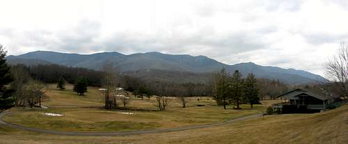 Great vantage point from the golf course on NC 80.
The most popular access point for the Black Mountains is the parking area near the summit of Mount Mitchell in the Mount Mitchell State Park.
To get to MMSP, take NC 128 north from the Blue Ridge Parkway at mile marker #355. Follow this road up to the parking area.
**Parts of the summit area are currently off-limits as construction of a new observation tower is underway. This period should end soon...***
Black Mountain Crest Trail.
The best way to experience the Black Mountains is to hike the Black Mountain Crest Trail. This trail, considered by some to be the toughest in the East, runs from Bolens Creek Trailhead in the north to the picnic area just below the summit of Mount Mitchell.Along this trail, one will encounter a number of the South's 6,000-foot peaks. In addition, you will have ample opportunity to experience the Fraser fir forests that dominate the upper reaches of these mountains.
Here is a link to my Black Mountain Crest Trail post.
 On Mount Craig.