
-
 5267 Hits
-
 73.06% Score
-
 3 Votes
|
|
Route |
|---|---|
|
|
51.22090°N / 115.7167°W |
|
|
Alpine II |
|
|
A long day |
|
|
5.5-5.7 |
|
|
5.6 (YDS) |
|
|
Approach
This is a 4000’+/- ascent day and I recorded 4300’ on my altimeter. Following my own nose instead of the guidebook resulted in a more ideal approach. Venture up the large boulder drainage, following it into a short narrow section of a canyon and to the first boulder field on your left. Ascend this boulder field, firmer ground found to the right. Eventually it peters out into trees and brush. When plausible, scramble over several short ridges on your right to ascend a southeast-northwest ridge that takes you up to great views of the Bow Valley, with a direct view of Castle and Stuart Knob to the northwest. This ridge makes for enjoyable ground of the sheep grazing variety. As the ridge starts to bend more north, The Finger will come into an immediate and clear view. This is also the spot I observed a kid goat and its mother scurrying down rock slopes on my left. It is highly unusual to see goats in this area. It was amazing the amount of rock fall they caused, yet appeared to remain unharmed. Goats 90% of the time will attempt to stay above you, but once they lose that edge, they make a beeline below you. Now make a direct path to the start of the route on the southwest face (see marked route photo). By doing this, you will save some elevation gained and lost. This approach avoids a major scree ascent via the guidebook directions. Just crossing this scree to get to the southwest face was not a pleasant experience. |  | 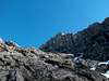 | 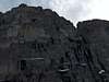 |  |
Route Description
The first pitch follows a water worn groove up a full rope length to pro attached to the left facing wall. Be careful not do dislodge rocks on your partner below. Loose debris does get washed down this section of the route. Then traverse right (we went un-roped) over ledges to the base of a narrow chimney. On our second pitch, we opted to stay out of the chimney as it was chocked full of snow and climbed a decent rock route to the right ,up and over and stayed on the face versus dumping into the left flake early. The good rock and 5.7 climbing led us back onto the flake. No station was found on this pitch, so we ran the rope out and found a decent one man ledge and made a station. One more full pitch tops out over this flake, but do not run the rope all the way out. This will only put you on a very loose ledge and drop rock directly below and onto the belayer. As soon as you begin to reach the end of this flake, set up a station immediately to the right, below the rocky ledge (again using your own pro). The rock fall had us in such a state, that after this 3rd pitch, we packed the rope away and went solo the rest of the route.Traverse right onto a down sloping angled narrow piece of slab and continue to contour around the right side of the face, picking your spots carefully. Eventually it looks to split, one option going higher and the other lower, take the high road and it will land you on the airy, but scenic ridge. Enjoy the huge waterfalls coming off of Cockscomb Mountain to the east and proceed up the ridge into very solid rock. The summit east face provides several fun, but exposed problems. We did climb over two solid pitons, but chose to leave our rope in the backpack. Once over these pitons, on to the summit and views of Assiniboine to the south as well as a close up of Mts. Cory, Copper and Pilot. Castle and Stuart Knob can be viewed to the northwest and the Sawback range dominates the east beyond Cockscomb Mountain.
For descent, downclimb the north ridge for a short distance to an obvious break in the ridge. Here you will find three pitons on a slanted smooth ledge serving as your single rappel off the north side of The Finger. We reinforced the existing cord with our own and added rings in June of 2005. Rappel off of the smoother edge down to ledges below (60 meter rope). From here downclimb to the snow filled north col and fit your gaiters for the glissade into the west drainage that leads back out to the Bow Valley Parkway approximately 1.1 miles north of your vehicle. We had recent heavy snows (even though it was late June) and it was sliding as soon as I jumped into the first rib down the north col. Therefore, I traversed at an angle to more shallow snow to the north and kept well ahead of my partner, dodging the rock fall on descent. Make sure the 2nd person is liberal with calling out “rock” on descent. It flows freely down this slope. Once down to the running drainage, stay left at first, but eventually you will criss cross the rapidly flowing creek and waterfalls several times. Resist the urge to seek softer ground into the trees. You will be forced back into the drainage on every occasion, which is typical of our canyons here in the Canadian Rockies. We came out to the road at exactly the same spot where a large bull elk was grazing, so had a hitch in no time (even though the road was supposed to be closed to through traffic) back to our truck.