
|
|
Route |
|---|---|
|
|
39.40620°N / 105.9487°W |
|
|
Off Trail Hike |
|
|
Half a day |
|
|
Class 2 |
|
|
Approach
Boreas Pass Trailhead
From the town of Breckenridge, drive to the south side of town. Near the Conoco station, turn East onto the Boreas Pass Road. It is well marked.
Drive 3.5 miles to an obvious parking area where the road turns to dirt. This is the site of the Winter closure. The Boreas Pass Road closes the first Monday of November, and typically re-opens in mid to late Spring.
If the gate is open, you can drive 6 more miles to the summit of Boreas Pass. This dirt road is well maintained, and is accessible by 2WD vehicles when it is dry. If the road is wet or snowy, you will want 4WD. There is ample parking at the Boreas Pass summit.
Route Description
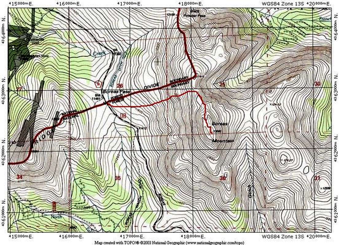
Refer to the TOPO and route photos below for the following text.
From the summit of Boreas Pass, hike past the huts and aim for the ridge between Boreas Mountain and Bald Mountain. You should be able to see Point 12,815 from the road. Aim generally for the right side of this bump as you hike up to the ridge. There is a faint use trail on this slope that will ease your upward progress. It follows the path of least resistance over grassy slopes through the loose rocks. Once you gain the ridge, take a moment to walk to the edge and take in this beautiful view.
After you bypass Point 12,815, the rest of the route will be visible ahead of you. Boreas Mountain has an odd-looking trough on its summit. Enter the trough on use trails. The best trail skirts the right side of the trough. Continue until you can see the actual summit ridge, which only becomes visible once you are halfway up the trough. Gain the summit ridge and walk to the summit.
Route Stats:
From Boreas Pass Summit
Round Trip Mileage: 3 miles
Elevation Gain: 1,700 feet
From Winter/Spring Road Closure
Round Trip Mileage: 15 miles
Elevation Gain: 3,000 feet
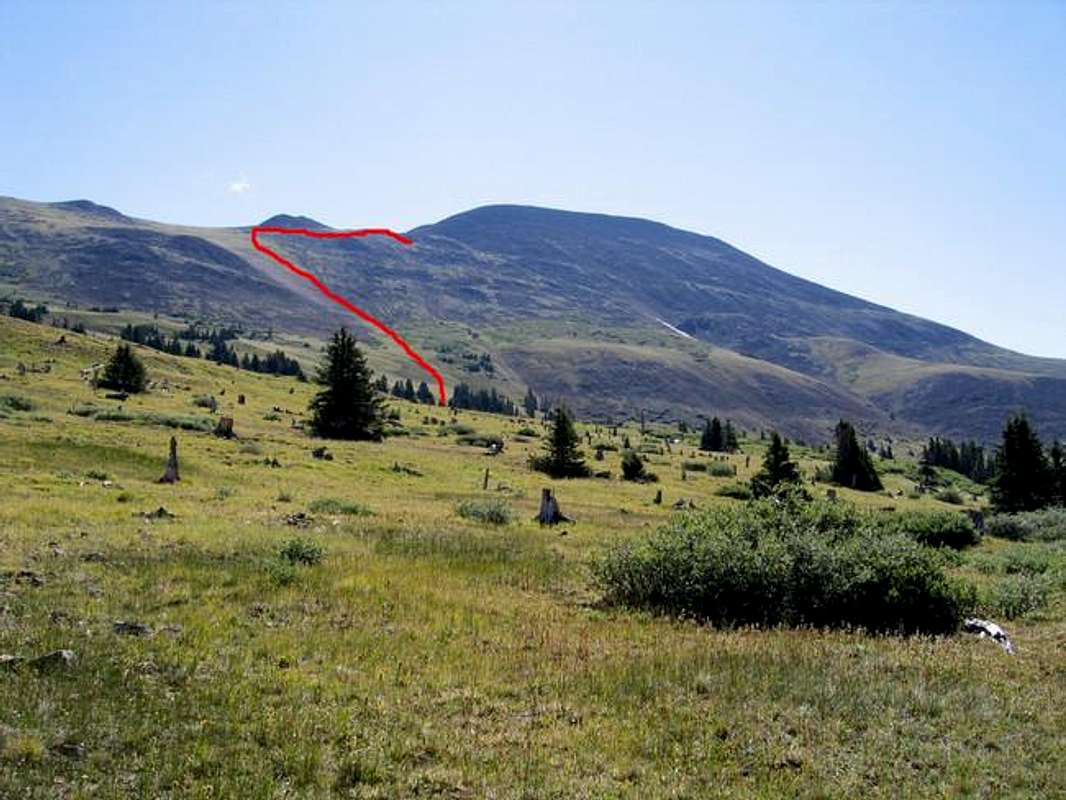
This route photo shows the path of least resistance from Boreas Pass. The red line follows a use trail
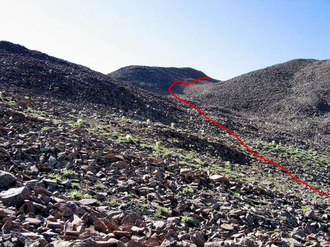
This route photo shows the remainder of the route from near Point 12,815 through the "trough." The summit is not visible.
Essential Gear
For summer, hiking gear only. Winter and Spring will require appropriate gear for those seasons. Traveling the Boreas Pass road during snow season will be much aided by cross country or Randonee skis. This area is popular with snowmobiles, so you might find the road packed down.