
|
|
Area/Range |
|---|---|
|
|
41.43539°N / 19.86122°E |
|
|
Overview
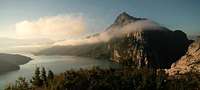
Mist over the shoulders of Mt. Bastarit and the Bovilla lake below. Photo: Hupe, Open-Air-Image.de
The Gorge at Lake Bovilla is a nearby hiking, rock-climbing and swimming area of signficant beauty nestled in the coastal range of limestone mountains in Albania which rise directly behind Tirana, the capital city. It probably offers the most significant single area of rock climbing in the capital region of Tirana-Shihak-Durres-Kruje, and is about an hour and fifteen minutes drive from downtown Tirana, perhaps longer if there is the usual traffic getting out of the city.
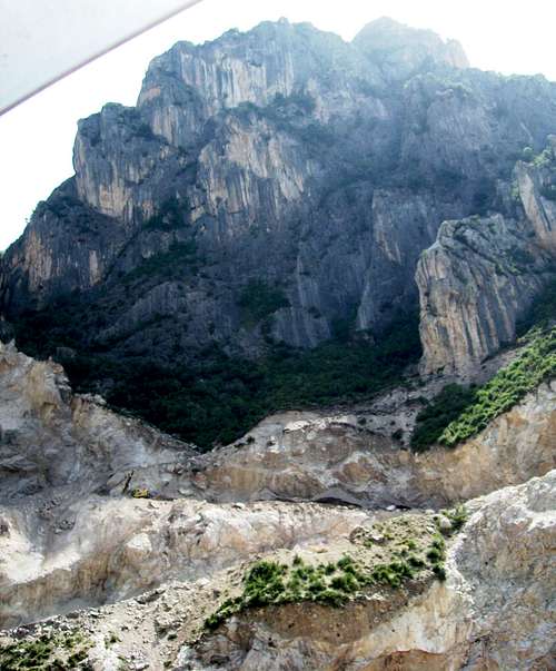
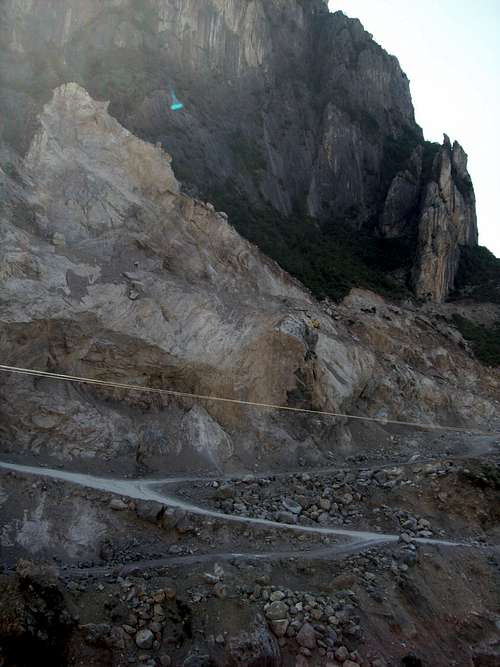
Soon after the transition from the old socialist regime, a new water supply was established by damming the Zallit te Bastarit River at the top of the gorge dividing the coastal mountains of Mt. Bastarit (1403m), to the south, from Mt. Gamtit (1268m), to the north, creating Lake Bovilla. Bastarit and Gamtit are two of the four major peaks in the coastal range, and lay in a row between Mt. Kruje to the north and sitting over the city of Kruje and Mt. Daiti to the south rising over Albania's capital city of Tirana. While there is rock climbing potentiality at several spots in this coastal range, without a doubt the most beautiful and accessible rock climbing is found in the gorge formed by the Zall River around the reservoir known as Lake Bovilla, the Bovilla Gorge.
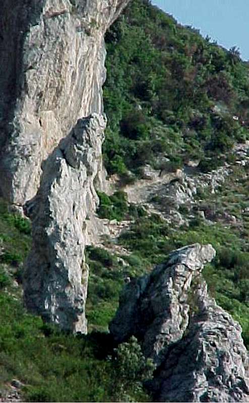
The front or western sides of Gamtit and Bastarit are mottled with a proliferation of crags and slabs, especially on the elevations in direct vicinity of the western gorge entrance.
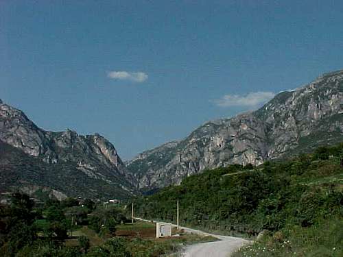
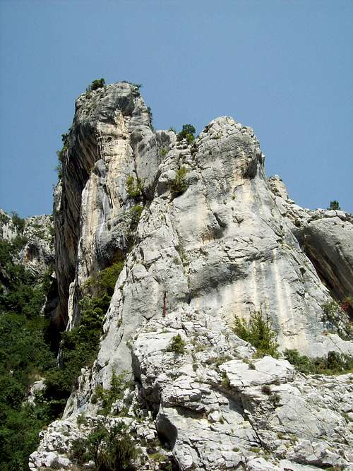
Bovilla Gorge Entrance: the three crags of Gamtit’s south shoulder appear on the left, the vertical faces of Bastarit’s north shoulder on the right, and the back ridge of Bastarit rising from Bovilla Dam visible in the center of the picture.
A series of dragon-like ridge backbones drop into the gorge from both peaks, the most significant of which is the final formation which forms the eastern entrance to the gorge where the dam was built and the reservoir begins. The northern or left hand formation is the most accessible, as the road through the gorge travels up the northern side of the stream until it switchbacks through the dam structure, with the switchbacks continuing up the shoulder between the eastern faces of Gamtit and the steep hillsides which drop into the reservoir.
The first two sport climbing areas in Bovilla, which has much more potential, have been set up on the steep and overhanging south-west Tufa Palisades directly above the dam, and on the flattened and less steep face of Lakeview crags which rise above the road facing the lake to the east.

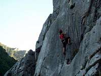
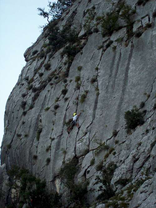
Gerhard Duro on the first ascent of Pirate Jenny, 5.8, Tupa Palisades, Bovilla Gorge.
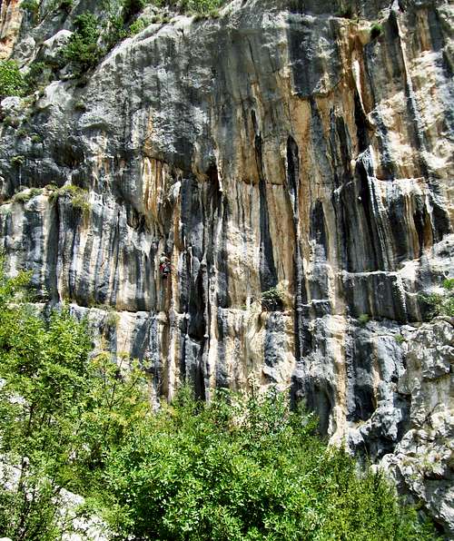
The Tufa Palisades include a set of recently set single pitch sport routes on the lower most formation, and rise in a series of steep and overhanging faces and shoulders up the side of Gamtit, where they are capped by a large and striking block-tower like formation on the cap. Vertical or overhanging on most sides, which all appear longer than a full pitch, it can be approached and surmounted by the third class route on the east side by going up and north of the extant Lakeview Bluffs routes. The Lakeview crags continue to rise to the north in a series of corners and slabs. While relatively vegetated with scrub oak along this face, the stone is of generally high quality and much climbing potential is in evidence.
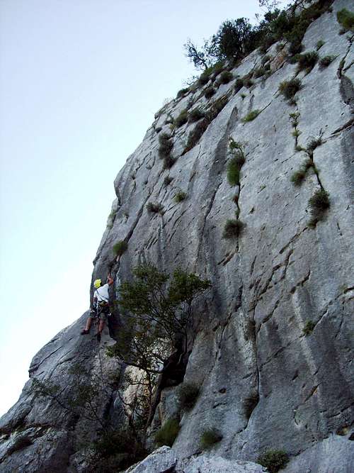
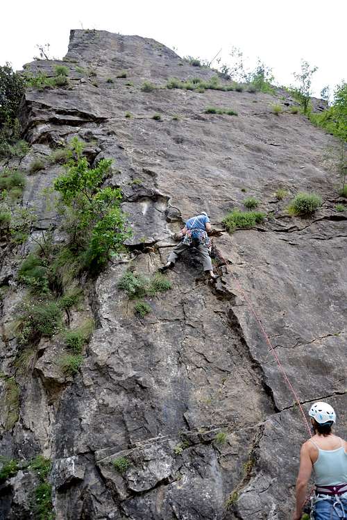
Tine Schrammel puzzled at the crux of Steffen Heimann's route 'Schrammelweg', UIAA VII-/5.10c, on the Lakeview Bluffs. Very fine rock is evident once sufficient cleaning and gardening is accomplished.
The Bovilla road rises in switchbacks along the eastern or back side of Gamtit, and travels north past the back side of Mt. Kruje until it turns back west meeting the old Burrell road near the city of Kruje. Along the way, there are several additional crags that rise above it.
The south side of the same formation rises up Berarit in one long snaking cliff formation facing west, and this same formation is composed by two remarkable looking pillars dropping into the lake. While they are partially vegetated – especially the lower one – the more problematic aspect is that the original approach, through the tunnel to the reservoir intakes, and along a goat path beyond, is now restricted by the officers who guard the reservoir; and an approach from the other direction around the lake would probably require a boat.

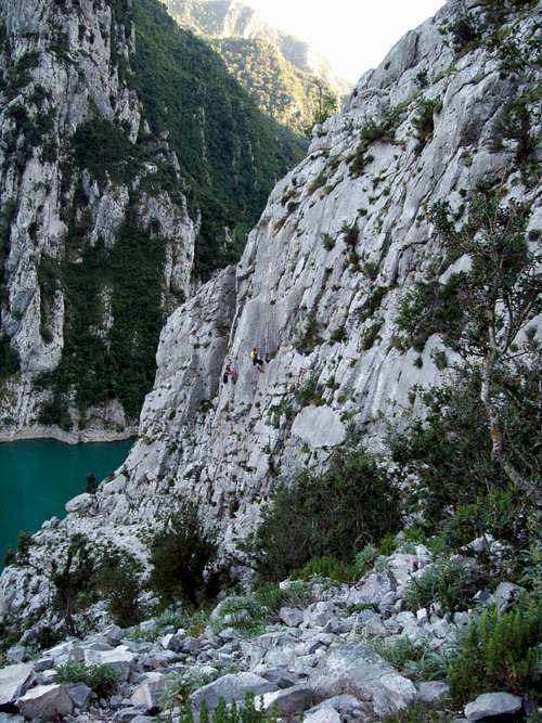
The base of the Lakeview Bluffs offers a nice view of the dam and lake below, with the two distinctive pillars rising above to the south shoulders of Mt. Berarit.
Area Locations and Route Descriptions
Tufa Palisades
The first sport area to be developed at Lake Bovilla is a portion of the massive tufa palisades which form the upper left ramparts above the Bovilla Dam. It is possible to park in a switchback on the south side of the earthen dam’s face, below a smallish 15 meter pinnacle, where a trail leads via a pile of rocks onto a limestone spur leading up and left past some electrical lines, and into a steep rubble gully from which one can access the available routes which are one the steep slabs before and in an overhanging amphitheater with several striking tufa columns hanging down it.
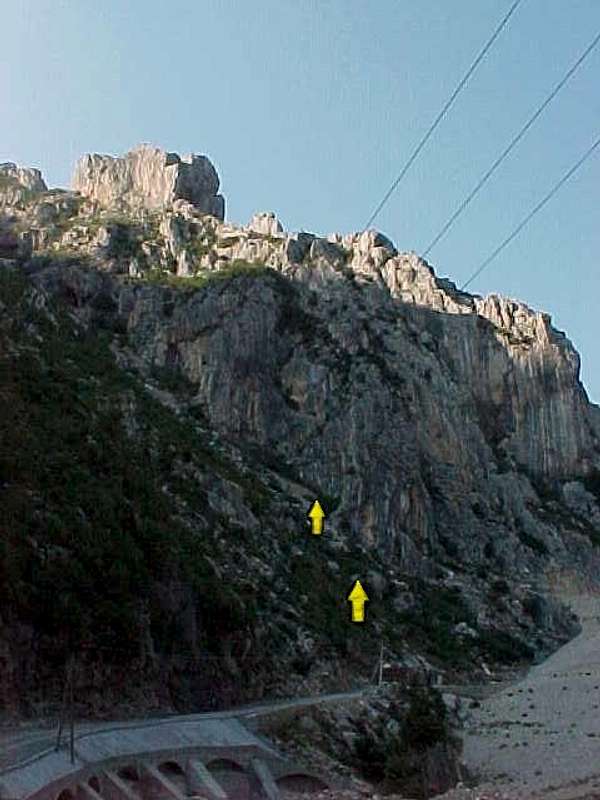
The Tufa Ampitheater on Bovilla's Tufa Palisades has several new routes. The yellow arrows indicate the approx. start locations of 'Elephant' and 'Mack the Knife.'
Area - Tufa Ampitheater - Route List
Elephant – UIAA IX/5.12b – FA Gerald Krug
Jack Sparrow – UIAA IX-/5.11d – FA Gerald Krug (TR only)
Old Route – UIAA II/5.3
Twist – UIAA VIII-/5.11b – FA Gerald Krug
Pirate Jenny – UIAA VI-/5.8 – FA Gerhard Duro and John Ely
Mack the Knife – UIAA VII+/5.10d – FA Steffen Heimann and Gerald Krug
Shark – Left Side UIAA V/5.7 (Right Side 5.5) – FA Steffen Heimann and Gerald Krug
The overhanging walls and steep buttresses of the Tufa palisade of Lake Bovilla viewed end-on from near the dam. Tufa ampitheater is down and the left; the Lakeview bluffs form the right skyline. The textured faces of this buttress have seen no climbing activity yet.
A schematic map, and topos of the two sport climbing areas in the Bovilla Gorge, and access to the canyon and swimming pools. G. Krug, Geoquest Press, Halle, Germany. Download here.
Chris Hupe did a lot of the hard work putting in 'Elephant' on the overhanging tufa, with adept use of cliff hangers to hold her fixed line against the rock. 'Jack Sparrow' climbs the tufa just to the left.

Gerald Krug managed the first ascent of 'Elephant' (UIAA IX/5.12b) after the hard preparation work of Christane Hupe. It reminded him of laybacking and etc. up an elephant's hanging trunk....
Lake View Bluffs
Parking for the Lakeview bluffs is found in a gravel yard with some decaying storage buildings immediately after the dam on the right by the banks of the reservoir. A goat trail switchbacks up on the other side of the road through the brush to the base of the ‘wall’ a short 25 meter limestone ridge-formation before the bluffs. A scramble through a notch on the right side of this leads to the bluffs. (Care should be taken between the wall and the bluffs proper, as large rocks dislodged here could make it all the way back down to the roadbed.) When the first ascent team arrived, it found several anchors evidently used for rappelling exercises and two bolted routes which it assumes were put in by Albanian commandos or Italian KFOR, depending on the reports. The bluffs continue in long tiers up and to the right. Only one pitch routes on the first two, lower tiers have until now been done.
Area – Lake View Bluffs - Route List
‘Old Route’ – UIAA II?
‘Special Forces’ – UIAA IV 5.5? – FA Italian KFOR?/Albaniian Commandos?
Chris Crack – UIAA VII-/ 5.10c – FA Gerald Krug and John Ely
Schrammelweg – UIAA VII-/5.10c – FA Steffen Heimann and Gerald Krug
German Oxygen (aka Beer) – UIAA VII-/5.10a – FA Gerhard Duro and John Ely
John’s Idea – UIAA V, 5.7 – FA Gerhard Duro and John Ely
Bohrlaub (‘Drill-cation’) – UIAA V, variant right VI/5.7, 5.8 – FA Gerhard Duro and Christiane Hupe
Project Duro aka Sticky Fingers – UIAA VII-/5.10c – FA Gerhard Duro and Tine Schrammel
Gerhard Duro working on a crack in the upper tier of the Lakeview Bluffs, one which remains unfinished.
Free Topo of the Lake View Sector, Lake Bovilla. Created by G. Krug, Geoquest Press, Halle Germany. Download here.
Christiane Hupe(left)and Steffen Heimann (right)putting in the routes 'Chris Crack' and 'Schrammelweg' on the lower tier of the Lakeview Bluffs, with the blue water of Bovilla Lake in the background.
Gerhard Duro working on his route 'Sticky Fingers' (VII-/5.10c) on the second tier of the Lakeview Bluffs.
Roadside Slab - Bob's Your Uncle Slab
Two new visitors to Albania, Maria Lodin from Sweden, and her husband Brian Robinson from British Columbia, Canada, have started out their adventures by developing the Roadside Slab in Bovilla Gorge in the summer of 2013.

The roadside slab below Bovilla Dam has had its routes developed in the summer of 2013 by the multi-national team of Marian Rodin (Sweden) and Brian Robinson (BC, Canada).
Bob's Your Uncle - UIAA VI/VI+, one pitch
Route Description:
"The route begins and follows the obvious narrow ramp and continues up a series of steps and edges. Small nuts in the beginning are more for helping anchor the whole route than they are for protecting the start, but do hold short falls as I have tested them.
Pass the first obvious horizontal crack to a comfortable hands free stance at the second obvious horizontal crack. Good gear here and in the small crack above protects a ’balancy’ move out left on small foot holds, to a good ledge where you place a small cam or nut in the vertical crack above you.
Continue to the third horizontal face crack where it meets the beginning of the roof to your left. A 00 DMM cam and solid medium nut on runners protect a small traverse out left and under the roof. A good slot beneath the roof accepts DMM cams to size 1 and there are various options for back ups to protect the semi strenuous roof moves involving stems to reach a 4 finger pocket hidden on the face. Pull up to arrive at a comfortable hands free stance above the roof.
Take a rest and plan you next moves because it involves a mandatory run out.
Using the 4 finger face pocket for a left foot, and small edges and crimps begin your second move above the roof and extend the run out. Don’t stop at this point to consider poor gear options in this balancy position, but reposition and continue further for a good stance and good gear. A fall during either move above your roof gear will land you on either of the two ledges below, the lower involving trees.
Congratulations, the crux is complete.
From here, follow the obvious crack system with good gear options to a loose block where it meets the far left side of the wall. Leave it alone, it has nothing to do with the route and will stay there if your not rough with it.
Follow the crack and various holds and good gear out right and then back left to a large ledge big enough to sit down and enjoy the view.
A good horn with a long runner can be used to redirect your route as you move out right following cracks, pockets and edges with good gear to continue and finish just right of the dead tree. A short traverse right will land you at a three point anchor.
Variations on the final moves involve face climbing on tiny foot holds with cracks for fingers, or an all off sideways dyno to a two handed ledge that should be reserved for the second climber.
Two 60m ropes complete the rappel.
The overall rating is Swedish Grade 5, and the crux section and roof Swedish Grade 6. This translates into UIAA VI/VI+, or YDS 5.8 with three 10b crux moves."
Experienced climbers comfortable with run outs above their own gear will find the crux section enjoyable , and will find the overall climb a pleasure on holds we all dream about.
FA: Brian Robinson, Canada & Maria Lodin, Sweden
FFA (First Female Ascent) Maria Lodin, Sweden
Route name: ’Bobs Your Uncle’ (6) Est July 2013 Bovilla Gorge
(Route description provided by first ascent party. They report further variations on this climb, the main route possibility up the roadside slab.)
Brian Robinson low down on his new route Bob's Your Uncle, belayed by Maria Lodin. Photo: Jeff Dokmo
Brian Robinson rappelling after the first ascent of Bob's Your Uncle. Photo: Maria Lodin, July 2013
Other Bovilla Areas
Only two small areas have begun to be developed in the large landscape that is the Tufa Palisade; and this is only one of the larger and more accessible of the multiple crags in the Bovilla Gorge. There are many other likely areas.
This includes the rising face of the southern Bastarit end of the formations around the dam, which can be accessed by climbing the steep slopes of brush oak just below the overflow sluice gates. The upper pillar is also enticing, but requires crossing the lake to gain access.
Swimming Hole Pinnacle - 'Stinky Pits' Route UIAA VI+ (5.10a) R
A 25 meter pinnacle is found rising out of the canyon just below, quite visible from the Bovilla Gorge swimming hole. This Swimming Hole Pinnacle was first climbed by Maria Lodin and Brian Robinson in three short pitches in Sept. 2013. This is their description:
The route begins low on the pinnacle skirt over easy 3rd class ground until it gets more vertical, while aiming for an obvious crack system between two large blocks. Nuts and cams to size 2.5 protect the airy stem up and over the block. From there continue on 5th class ground with good protection to a good crack and flake. Belay the second to this point to avoid serious rope drag over un-protected ground on the second pitch that finishes at a small col beneath the peak proper. The second pitch begins up and to the left of the belay on dead vertical rock, and then traverses right on un-protected vertical ground above the belay while aiming for a notch beneath the over hanging upper section to make the col. Serious climbing on the second pitch with an unprotected traversing run out. Once at the col, multiple belay options exist to bring up the second. From the col, 8m of 5th class climbing will land you on a very sharp and pointy peak. Down climb or rap back to the col, and from there walk a short distance off the south side and turn right for great tree options for rappelling.
A single 70m rope was used and was plenty for the rappel. R rating for the second pitch.
Overall length is 60m.

Swimming hole pinnacle. First climbed by Marian Lodin and Brian Robinson, 2013.
The other areas of most potential are found at the eastern entrance to Bovilla Gorge. Most notably these include three striking crags on the northern side, of which the left-most is the largest, and the right-most includes a spectacular overhanging and rising crag of some 80-120 meters. The easy UIAA I-II ridgelines and chimneys therein of the leftmost crag were climbed in 2001 as a reconnaissance outing, but the rest of this area is unclimbed.

The third of the crags on the shoulders of Mt. Gamtit near the Bovilla Gorge entrance has some of the most overhanging rock.

The first or leftmost of the Gamtit entrance crags has some interesting lines. Only the easy fifth class ridge lines have seen a rope.
Above the leftmost crag, another large formation is evident high on the side of Gamtit. Though there is no road, walking northward along the base would bring one to another collection of crags.
The north-western shoulders of Mt. Berarit to the south are also full of sturdy limestone, especially in the form of steep faces and slabs rising in tiers up the western side. But especially the lower of these are endangered by thoughtless and controlled quarry activity described below.
Degradation of the Bovilla Crags by Cement Quarries
A series of buttresses, steep faces, and less steep slabs rise like layer cakes up the shoulders of Mt. Bastarit south of the entrance. The status of these for future rock climbing is uncertain however, for despite the beauty of the area, the last few years have seen the development of a cement quarry out of the south-east entrance which has already led to the destruction of many beautiful rock formations on the lower half of the gorge. This includes a number of quite beautiful large limestone pinnacles at the north entrance and the various formations around them. Fortunately to now, the main formations have not been blown apart and transformed into the sort of cement that could be recovered from any of a multitude of less valuable and less beautiful parts of Albania. It is to be hoped that this policy of destruction of the natural beauties of the country, above all, those in the immediate vicinity of the capital city, will soon cease and be limited only to the present extent of abuse.Photos Illustrating Destruction by Cement Quarrying in Bovilla
A view of the destruction of Bovilla's south canyon wall due to the cement quarrying. All the the cliffs above are presently threatened by this senseless destruction of the natural beauties of the country. Aug. 2010.
This beautiful pinnacle, a short but interesting 5.9 problem by its easiest ascent, has been destroyed by the cement quarriers. (The author has seems climbs he has done on several occasions changed or even destroyed by natural rockfall, but only in Albania has this occurred due to senseless extraction industry.)

A view of the left canyon wall before destruction, taken in the summer of 2001
This view of the south entrance of Bovilla Gorge shows what the same area looks like after it has been blasted apart to make cement. Photo taken Aug. 2010.
Sun Patterns and Swimming in Bovilla Gorge

Looking into the natural carst flume of the Bovilla Swimming hole from above.
The coastal regions of Albania are hot in the Summer. Fall and Spring are doubtlessly the best times to climb in this area; but Bovilla is preferable to many areas in the Summer because of the superfluidity of climbing possibilities with different regard to the movement of the sun. The Tufa area and other comparable west facing crags have shade in the morning, and the Lakeview Bluffs and other east facing crags have shade in the afternoon.
Though one will see swimming in the reservoir, as it is largely unregulated, it is obviously very poor form to swim in the city's water supply. But below the sluice gates, there is a wonderful natural carst flume in the river bed. (See the schematic map above for precise location.) Here one can park and walk down the steep trail to a delightful swimming hole, with a magnificent outlook from the water into the gorge below, and the possibility of diving, and swimming upstream through a series of overhanging carst formations, ducking the head finally under a narrowness to find a darkened cave of swirling waters falling in and forming a natural jacuzzi.

Diving into the Bovilla Swimming hole. Photo - Hupe, Open-Air-Image.de

Swimming in the Bovilla swimming hole.
The swimming hole makes a natural lunch spot for high noon siesta while one waits for the sun to shift from east to west.
Getting There
Bovilla Gorge between Tirana and Kruje contains the best rock climbing available in the greater Tirana area. It can be reached via a twenty minute trip down the road to Zall-Herr that turns right at the Bathore intersection one kilometer south of the town of Kamez (pronounced 'kam-ze') on the old Lezhe-Shkodra Road.
Turnoff to Bathore and thus to Lake Bovilla from the road to Kamze.
The road rises as the road cuts through the gorge on the north side after crossing a bridge at the entrance to the gorge and then rises, passing the Bovilla Dam. This dam holds the drinking water for the city of Tirana in the reservoir.
A map indicating the way to drive to Lake Bovilla and its gorge from the capital city of Albania, Tirana. Prepared by G. Krug, Geoquest Press, Halle Germany.
Camping
About a kilometer and a half up the steep switchbacks beyond the reservoir, one reaches a spring in the side of the road and a striking large oak, still living, but hollowed out on the inside. Several meadows and flat gravel areas in the immediate vicinity offer good camping with a striking panorama of the lake and the surrounding bluffs.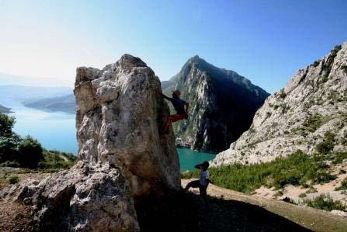
Gerald Krug on the Campground Boulder, spotted by Gerhard Duro. Photo - Hupe, Open-Air-Image. The small fan of the 'wall' and the several tiers of the Lakeview Bluffs are visible behind the boulderers on the right.