
|
|
Mountain/Rock |
|---|---|
|
|
34.08580°N / 118.7218°W |
|
|
Hiking, Mountaineering, Scrambling, Canyoneering |
|
|
Spring, Summer, Fall, Winter |
|
|
1713 ft / 522 m |
|
|
Overview
 Cross on Brents Mountain
 Brents Mountain
Brents Mountain is a distinct, impressive peak located in the Santa Monica Mountains near Malibu Creek State Park. Although only 1,713 ft in elevation, this peak is very prominent with 1,200 ft gain in just over 1/2 mile. It is easily recognizable with a white cross on the summit.
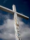 Close-up of Cross
Climbing to the summit of Brents Mountain is not a simple endeavor. There are no trails, you need to follow a steep drainage or wash (definition - dry stream bed: the dry bed of a stream that flows only after heavy rains, often found at the bottom of a canyon) up near the summit, requiring some route finding and heavy bushwhacking if you get off route. Also, there is HEAVY poison Oak almost all the way up if you follow the wash. There are steep, class 3 sections that require simple rock climbing. However, it is all worth it. The views from the summit are excellent. To the south you can see the entire Backbone Ridge, surrounding mountains, the rock pools, the Goat Buttes (impressive mountains surrounding the rock pools) and as far as the ocean.
There is a Geocache at the summit of Brents Mountain. The Geocache log was the only information I found on the route to this summit. At the bottom of this page are GPS coordinates of the best route for this hike. This text can be downloaded to your GPS after file conversion.
Getting There
 Google Earth Image of Route
 Mott Road
 Beginning of Wash
Zoomable Map centered on Malibu Creek Campground
You can Zoom in and see the roads and trails I am referring to below. Note, Mott Road is labeled Century Motorway on this map.
From 101 Freeway:
Via Mulholland Highway - Grassland Trail (See Topo Map):
Take the 101 North from LA to Las Virgenes Road Exit near Malibu. Drive south along Las Virgenes, through Calabasas, and turn right on Mulholland Highway. Drive about 1/4 mile and park on the side of the road near the "Grassland Trail" sign. Do not head north and follow the North Grassland Trail. Cross the road and follow the "south" Grassland Trail all the way to "High Road" leading to the visitor center. Turn left on the road for a short distance until you can cross the creek.
Malibu Creek State Park:
As for the grassland trail, take the 101 North from LA to Las Virgenes Road Exit near Malibu. Drive south along Las Virgenes, this time past Mulholland Highway and turn right into Malibu Creek State park and park at the parking lot (it costs $8 to park, plus buy the trail map for $1). Follow the dirt road towards the visitor center, take the trail to the left and cross the creek after about 1/2 mile.
From Pacific Coast Freeway:
You can also take the PCH just north of Malibu and take the Malibu Canyon Road towards Pepperdine University. Drive North to either Malibu Creek State Park or Mulholland Highway (and turn left) and follow the directions above.
Once across the creek, follow Crags Road to the left (south) a short distance and them turn left on Mott Road. You will be able to see Brents Mountain and the cross on the summit. Head towards it. Follow Mott Road south just past the Adobe ruins and as soon as you see an opening in the rock follow the wash up towards the summit. If you are coming from Tapia park, you will follow Mott Road north and turn left just before the Adobe Ruins (it is worthwhile to walk the short distance and check them out regardless). It also costs $8 to park at Tapia park, and you need to get around the Salvation Army camp which has a few gates, so I recommend taking the grassland trail and saving the $8 (this is the route shown on the Topo Map below).
There are no trails to the summit and the easiest route that I know of is by following a steep wash (drainage ditch) all the way near the summit. I do not recommend diverting from the ditch as the bush is very thick. We tried a route that leaves the ditch and follows the first ridge (there is a 4 rock cairn at the spot we left the ditch for the ridge), but soon regretted this decision. We did make it to the top via this route, but the bush was so thick it was really unbearable. The basic rule is to stay in the ditch, continue up what I have heard called Brents Staircase, up some class 3 section, around pools of stagnant water, and stay to your left. This should lead you out near the top where you can see the summit and follow a steep trail to the summit. You can do not get any views of where you are going until near the summit, the canopy overhead is too thick.
Check out the elevation profile below, this shows how steep this route is. 1200 ft of gain over 1/2 mile.
Topo Map and Elevation Profile
 Elevation Profile
 Topo Map
This Topo Map shows the route from the Grassland Trail off Mulholland Highway. On our return we took the Chaparral trail to the visitor center and explored the rock pools (where they filmed planet of the Apes) and followed Crags road all the way back to the Grassland trail.
Click Here to View GPS Route in Google Earth
Camping
The most convenient place to camp is at Malibu Creek State Park Campground. It is located near Hulholland Highway and Malibu Canyon Road, just 25 miles from downtown LA. Here is a MAP.There are 15 miles of streamside trail through oak and sycamore woodlands an chaparral-covered slopes.
Twenty-five-mile Malibu Creek in the park is the principal water-course of the Santa Monica Mountains - from Boney Mountain to Malibu Lagoon.
The park was the center of Chumash Native American life for centuries and was once used to film numerous movies and TV shows, such as Planet of the Apes and M*A*S*H.
Reservations are usually required and can be made at www.reserveamerica.com
External Links
Mott Adobe Ruins
 More Adobe Ruins
 Adobe Ruins
The ruins are well worth the visit. The chimney is all that is standing, but you can see sections of the rock walls, tiles, carefully grouted rock flooring and various ruins. If you know more about these ruins please e-mail me so I can add some info. I could not find anything online.
GPS Track in txt format
Below is the GPS track data in comma seperated text format (csv) for the suggested route to the summit of Brents Mountain. By clicking the "Click Here for GPX File" button below, it will take you to http://www.gpsvisualizer.com/convert where you can convert the data to GPX format (by clicking convert).You can also cut and paste the data in the window below.