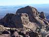
Bridge Mountain
This was a LVMC trip. We drove up Rocky Gap Road to Red Rock summit. The road was in good shape overall, but had a few rough spots. It definately requires a high clearance vehicle. We parked at 36° 7.868 N and 115° 31.992 W. Elevation at Rocky Gap Road is about 6,471 feet.
The sign at the trailhead tells you that Bridge Mountain is 2.2 miles and North Peak is 1.3 miles. Bridge Mountain was actually about 3.1 miles and the peak they refer to as North Peak is different than what hikers refer to as North Peak. North Peak is actually about 2.5 miles or so from Rocky Gap Road.
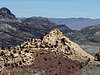
We hiked along the trail up to 36° 7.974 N, 115° 31.221 W. Elevation was about 7,180 feet. Then we started hiking down towards Bridge Mountain and slowly lost some elevation. There is a great lookout into Pine Canyon and Mescalito along the way at 36° 7.745 N, 115° 30.814W.
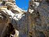
Many cairns mark the route along the way. When first looking up at Bridge and at the crack you have to scramble up through, it looks impossible. Once you get up to it though it looks manageable. Our LVMC group stopped and ate just before ascending into the crack at about 6,350 feet and at 36° 7.922 N, 115° 30.328 W.
The Crack and ascending to the summit
The crack you have to ascend up starts at 6,440 feet and is at 36° 7.939 N, 115° 30.325 W. At the top of the crack you will be at about 6,550 feet and 36° 7.945 N, 115° 30.299W. At this point you have to curve around to the left and then ascend a 2nd crack. This crack is at about 6,588 feet and at 36° 7.95 N, 115° 30.292W. Once you reach the top of this crack you will be right under the bridge. From here it was smooth sailing to the summit.
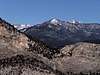
The summit of Bridge Mountain provided excellent views of Red Rock Canyon, Las Vegas, and the snow covered Spring Mountains to the NW. Our group enjoyed lunch and the photo opportunities.
The descent was very interesting. One of the members of our group lost a GPS. It rolled with great velocity down the mountain and off into an open area as the hiker was going down the exposed ledge not far below the summit. One of the members of the group was nice enough to go down and search for the GPS but had no luck. The club member that lost his GPS was in good spirits though and said he was ready to get a new better one.
North Peak
The majority of the LVMC group decided to do a side trip to North Peak. We found out quickly that the peak that is referred to on the BLM signs is not the true sandstone North Peak that is referred to, and it was much more than the 0.3 miles the sign says it was off the trail. It was a lot of short ups and downs on the way to North Peak. The views were well worth the trek to North Peak though. Las Vegas looked stunning as the sun reflected off the strip. North Peak also provides some great views of Bridge Mountain. We then hiked back to Rocky Gap Road and drove back down to the visitor center where people parked there vehicles. The sun was setting as we were on our return drive down Rocky Gap Road. It was a great day getting in 2 peaks and about 9 miles of hiking.
Comments
No comments posted yet.