
-
 9572 Hits
-
 84.27% Score
-
 18 Votes
|
|
Mountain/Rock |
|---|---|
|
|
47.15330°N / 9.27641°E |
|
|
Hiking, Mountaineering, Trad Climbing, Sport Climbing, Scrambling, Skiing |
|
|
Spring, Summer, Fall, Winter |
|
|
7477 ft / 2279 m |
|
|
Overview

Brisi is one of the seven Churfirsten located in eastern Switzerland, in the Kanton of St. Gallen. Of the seven, it is the second highest after the Hinterrugg, standing at 2,279 meters above sea level. It is easily identified within the group as the peak with a very long and flat, yet thin summit ridge. This differs from most of the other peaks in the Churfirsten, which show either very broad, dome like summits, or sharp pointy summits. The north flank of the Brisi is characterized by steep mixed grassy and rocky slopes. The sheer south face drops precipitously down to the Walensee in a series of limestone cliffs interspersed with grassy steps. The west and east faces separate the peak from it's Churfirsten neighbors, them being the Zuestoll to the east (2235 meters) and the Frümsel to the west (2267 meters), and again, are sheer limestone faces. This makes the north flank of the peak the easiest means to get to the summit, and in dry conditions, is a steep class 1 hike. Multiple rock routes exist on the south, east, and west faces. The peak may also be skied in winter or spring, yet climbing the Brisi with snow will require crampons and ice axe due to the steepness, yet the ski descent would be very enjoyable for any intermediate backcountry skier.
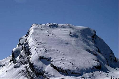
Ski tracks on the north flank
The views of the summit are spectacular. The south faces of all the Churfirsten are visible, dropping down to the Walensee. To the south, across the valley, the Glarner Alps dominate the majority of the skyline, a complex jumble of rocky peaks, some reaching over 3000 meters. The Alpstein is located just north, across the valley, and behind them, on a clear day, the Bodensee and the flatlands of Germany can be seen. If hiked from the town of Alt St. Johann, an ascent of the Brisi can yield about 1300 meters of elevation gain in about 7 kilometers. This can be cut in half thanks to the Selamatt chairlift that takes one from Alt St Johann to the 1400 meter level. From there, it's merely a ~4 kilometer hike with 800 meters of gain to the summit, taking no more than a few hours during the summer.
Getting There
The town of Alt St Johann is located in the Toggenberg region of Kanton St Gallen. From the freeway A13 in Hagg, take route 16 towards Toggenberg and Wildhaus. Go 18 kilometers to Alt St Johann, passing though the town of Wildhaus at 15 kilometers. the Churfirsten should all be visible to the south. Just as you come into Alt St Johann, make a left onto one of the first streets, and drive 10 seconds to the parking lot for the Selamatt lift. You'll be able to see the lift before you come into town, it's not hard to find at all. Park in the parking area here. The route description I've posted is from this point. If hiking from the top of the lift, go ahead and take the chairlift (14 CHF) and join the route from Selamatt.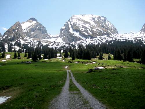
Zuestoll and Brisi