

|
|
Route |
|---|---|
|
|
38.30900°N / 107.633°W |
|
|
Hiking, Scrambling |
|
|
Spring, Summer, Fall |
|
|
Half a day |
|
|
Orienteering challenge |
|
|
Overview

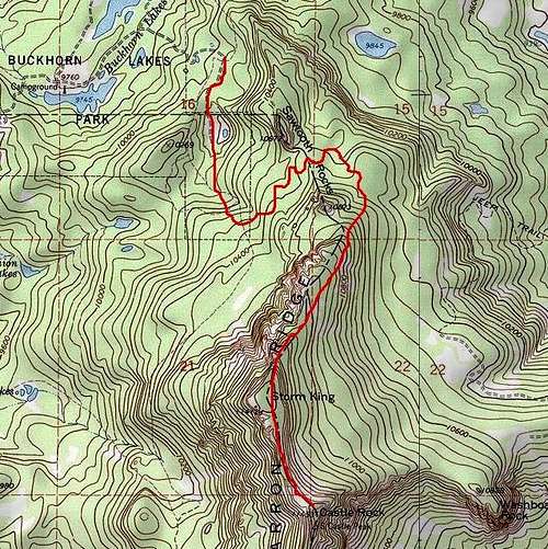
Castle Rock, even though its the highpoint of Montrose County doesn't see many summits. Because of this, there really isn't a formal trail to follow. Once the ridge is gained, there is an extremely faint/primitive trail to follow. The route gains 1,693' from Buckhorn Lakes, one way.
The only thing to really take heed about, is pay attention to your track and position on a topo map. For once you leave Buckhorn Lakes, it's nigh of impossible to discern your position as the forest is super thick and landmarks and features are largely hidden.
~6 miles round trip.
The 'true' route starts at the lakes (9760') near some shelters and campground. The book, "Hiking Colorado's Summits" by Mitchler & Covill details a decent route. It's longer, but that's due to it following an old, seldom-used ATV trail.
I'll also detail a route I used that's vastly different. It's much shorter but definitely harder as it follows an avalanche gully through the western cliffs.
Further Information: Buckhorn Lakes Quadrangle Colorado West Outdoors
Approach/Route
I've decided to combine these because once one parks at the lakes, there really is no route 'per se', in climbing terms. So I think it's more appropriate to describe these together.
Leave Buckhorn Lakes (9760') and follow an old 4x4 road northeast around the lager lake. This will deposit you at another campground. From here, the road will narrow somewhat as it turns south along the eastern edge.
Keep following the road south and east as it switchbacks higher and higher up towards CImarron Ridge. The road will slowly disipate into an old ATV track before disappearing entirely into the forest below Sawtooth Rocks. NOTE: The ATV track does NOT go to the ridge. Decide when to leave the track and bushwhack to the saddle just south of South Sawtooth Rock. The saddle is at 10,720'.
Once at the saddle, you'll follow a broken primitive trail to the summit of an unranked point called, Storm King. Fact, you more than likely won't even notice it. The elevation gain from the saddle to Storm King is around 700'.
Again, the ridge will be steep, there's PLENTY of deadfall and the forest is thick. Once you crest Storm King, most of the elevation gain is finished. When in doubt, just keep ascending due south.
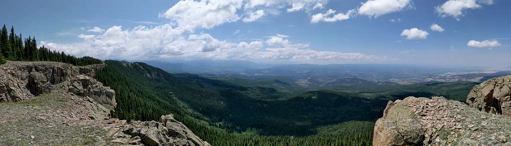
The views from Storm King are actually quite good. Take a few moments to wander over to the edge of the western cliffs and look out over the void. You'll see the Sneffels Range far to the south, Ridgway Reservoir and with a keen eye, highway 550.
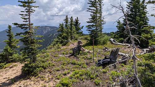
Continue south along the flat and broad ridge. Again, there isn't much elevation gain but you'll notice the highpoint (Castle Rock) by the communications tower and attached building. There is a register tucked away into the stump of an old tree.
My Route:
From the first campground at 9,760' at the main lake, follow an easy 4x4 road northeast through thick forest. It will eventually come to a fork. Stay to the right and head uphill to the east. At this point, the road will slowly disintegrate into another ATV track. Follow it due south until it stops at a flat area marked by a seasonal pond. The road/track effectively comes to an end here. In hindsight, this would be a good camping spot as it would be very quiet and remote.
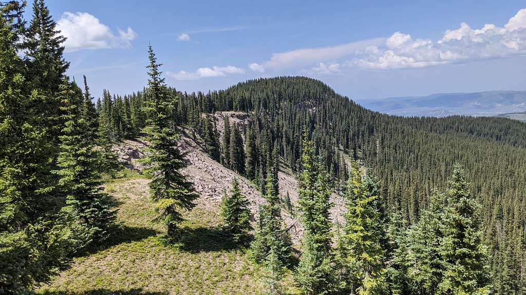
Continue south flanking the western cliffs for perhaps a quarter mile until an obvious gully comes into view. This is the ascent route. Leave the relitively flat, but copiously boulder-strewn bench (10,480') and scramble up into the gully. The gully is comprised of a patchwork of small grassy knolls, rocks of varying size and dirt. It's actually not bad.
Near the top, exit the gully climbers right, scamper over a small lip and into the next shallow gully. Do not continue straight up or left thinking there's a cut through the cliffs, there's not. And I wouldn't recommend attempting to climb them. It's crumbly Cimarron rock/dirt.
Once in the second gully, more like an open slope really, keep ascending straight up while traversing further to the right. Aim for the trees along the side. They provide more stable footing and something to grab onto to.
At the top of this second gully, a small, broken cliff band with small & tenuous holds will present. Work your way up and through this. Angling left as you do works well. Near the top, deadfall and more trees will be present. So there's a lot to grasp onto to ease this last little bit. You should pop out onto the flat ridge around 11,280'. Walk the remaing distance over to Storm King and enjoy the views.
Descend the standard ridge to the saddle below Sawtooth Rocks and start to look for the old ATV track back to Buckhorn Lakes.
Essential Gear
Orientation devices: Definitely bring a topo map at the very least. If you know how to use map/compass, bring it. GPS obviously is best. I'd also recommend some GOOD poles and solid boots. I used my poles much more than I thought I would. The forest is VERY thick and deadfall is everywhere. Also, mosquito repellent. There is a lot of water in this area during the warmer, summer months, in the shape of ponds, lakes, small black water ponds and streams.