Buffalo Peak SE Slopes
Add Overview text here.
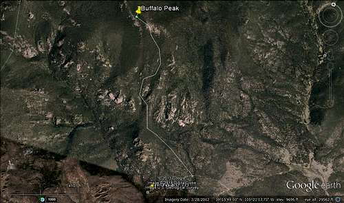
![Unnamed Image]() Unnamed Image
Unnamed ImageGetting There
From Colorado Springs take Highway 24 North to it's intersection with Highway 67 in Woodland Park. North on 67 to Deckers. Continue through Deckers to the West as 67 turns into 126. Follow 126 to the intersection with FR 560/211 which is a very fun and scenic drive in itself. The turn off will be on your left and is easy to miss. This road continues through the Hayman Burn scar to a T intersection where a right will keep you on your journey and straight leads down to Cheeseman Reservoir. Follow FR560 to a Y intersection. Stay right. This is Stoney Pass Road which will take you to your next turn which will be a left on FR545 that leads to the Wigwam TH. For this route we parked at a large established pull off/parking area, where we began this hike.
Route Description
Strenuous! Close to 7 miles round trip with 3500 feet of elevation gain. Prepare for a solid day of trail blazing and route finding. I would not recommend this route for anyone who cannot locate themselves with a topo and compass and landmarks. As the majority of the hike is in a thick evergreen forest. Start hiking NW, from parking area described in "Getting There", along the NE slopes of "The Wigwam" to an obvious saddle between the Wigwam and Buffalo Peak. This saddle turns into your main ridge to ascend. Continue N and W up this ridge. Traverse to the NW to avoid first cliff bands. Continue this general direction to around 9800 feet. At around this altitude we traversed to the NE staying to the W of point 9870. Turned back to the N and W at about 10700 feet and continued this direction to the summit. The STEEP climb relents as you get close to 11000 feet. Which was a nice change of pace. Encountered deep snow drifts on the summit ridge even though its sparsely populated with evergreens. From here head almost directly west to the eastern summit, which is slightly shorter than the "true" western summit. We climbed up the eastern summit and traversed it, instead of staying in the trees. The western edge of the eastern summit requires about 30 feet of down scrambling. From here the true USGS benchmarked summit is directly in front of you and requires very little scrambling to acquire. Enjoy the 360 degree views and the feeling of accomplishment to summit this mountain! We descended the same route described above. This is where your route finding skills come into play! Cheers!
Essential Gear
Trekking poles were very helpful. Other than that just your normal daypack kit.
External Links
Add External Links text here.

 6487 Hits
 72.6% Score
 5 Votes