
-
 17370 Hits
-
 81.89% Score
-
 15 Votes
|
|
Mountain/Rock |
|---|---|
|
|
39.09968°N / 106.4627°W |
|
|
Lake |
|
|
Mountaineering |
|
|
Spring, Summer, Fall, Winter |
|
|
13761 ft / 4194 m |
|
|
Overview
The Sawatch Range in Colorado has a plethora of opportunities for unforgettable mountaineering adventures. Within its boundaries, the Sawatch holds a total of fifteen fourteeners, four of which are within the top five highest peaks in all of Colorado. Therefore, it is no surprise that Bull Hill is not included on many peak baggers lists. It is however the highest named "hill" in the country!
At 13,761 feet, it is one of the Bi-centennial peaks in Colorado meaning it is one of the highest 200. Bull Hill, while being somewhat overshadowed by it’s larger and more “Massive” neighbors to the north and south, offers breathtaking views and plenty of opportunity to test one’s mountaineering endurance. Additionally, a climb of Bull Hill offers a bicentennial peak-bag before taking on higher peaks in the area. Mount Elbert, Colorado’s highest peak lies a mere 1.6 miles to the northeast, and 13,908 foot Casco Peak, a centennial thirteener ranked 69th among Colorado’s highest peaks lies 2 miles to the west. The corresponding ridge traverses to Elbert and Casco are fun scrambles. Bull Hill lies within the boundaries of the San Isabel National Forest in Lake County, but is not a part of any designated wilderness area. It can be climbed from at least two trailheads. Either option offers 3,000+ feet of elevation gain in a relatively short distance.
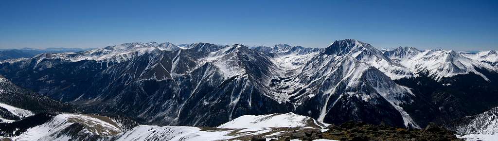
View across the valley towards La Plata and Rinker from Bull Hill
Getting There
From the Denver Metro Area, take I-70 West approximately 64 miles to Copper Mountain, Colorado. Take Exit 195 and merge with CO-91 toward Leadville. After 22.2 miles, make a slight right and merge with US-24 and follow it through the historic town of Leadville. You will remain on US-24 for 16.3 more miles until you come to the CO-82 (Independence Pass) junction. Take a right (east) on CO-82 toward Twin Lakes and Independence Pass. The Black Cloud Trailhead lies on the right 10.4 miles down CO-82 and the Echo Canyon Trailhead is unmarked and is slightly further at 12.6 miles on the right. The road is open to both of these trailheads in winter where you can just park off the side of the highway. Therefore, Bull Hill makes a great winter climb.
Route Options
Black Cloud Trail - Class 2
Starting at the Black Cloud Trailhead, head north on a well kept trail. After 1 mile, there is an unmarked left turn toward Fidelity Mine. This turn is fairly hard to spot and there doesn't appear to be much of a trail to the mine anymore. It's recommended you head up the main Black Cloud trail towards Mount Elbert until it turns north to climb up towards south Elbert. At this point, head up the valley then ascend the northeast slopes of Bull Hill, or ascend southwest through thin trees to reach the southeast ridge of Bull Hill. Either route will get you to the summit. This route gains about 4,000 feet in 3.55 miles.
Echo Canyon Trail - Class 2
Echo Canyon offers a scenic route up Bull Hill, passing through stands of aspen, next to a churning, bubbling creek, and past two historic mining sites. There is a lower start for 2-wheel drive vehicles at 10,000 feet, and an upper start for high clearance/4WD vehicles at 10,200 feet. Starting from the lower trailhead, be sure not to park on or cross into private property in the vicinity. Find your way up the rocky 4WD road for 0.25 mile to the sign marked TRAIL just a few feet from the cement barricade. Follow the trail across Echo Creek and start the ascent. After 1 mile, there is a trail that splits to the right. There is a rock marked “Mine” with an arrow in purple paint pointing the way. Follow this trail as it switchbacks up the southwest slope of Bull Hill passing Last Chance mine and later Golden Fleece mine after another 1.4 miles. From Golden Fleece Mine, the slope steepens, and passage becomes a bit more difficult, but this trend lasts for only a few hundred feet until you are above the mine. From here, follow the grassy ridge for 0.7 mile to the summit. This approach is approximately 3.4 miles from the lower trailhead and gains 3,772 feet. A start from the upper/4WD trailhead will require 3.1 miles and a gain of 3,574 feet.
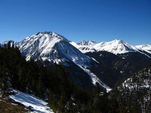
Echo Canyon approach with La Plata in the background
Casco/Bull Hill Traverse - Class 2+
From the summit of Casco Peak, the traverse to Bull Hill is a nice scramble but the rock is fairly loose. Any difficulties on the ridge can easily be bypassed to either side.
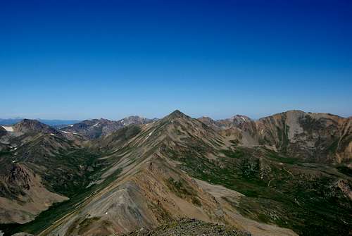
Traverse to Casco Peak
Elbert/Bull Hill Traverse - Class 2
This ridge traverse is a fun hike allowing you to also summit the unranked 14er "South Elbert". The ridge has a couple steep sections but doesn't exceed Class 2.
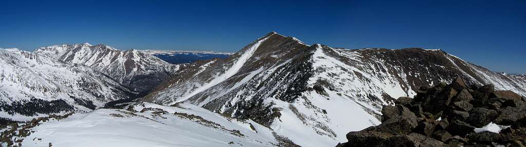
Mount Elbert from Bull Hill
Maps
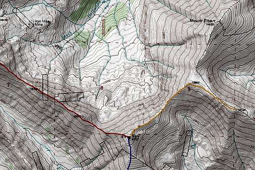 | 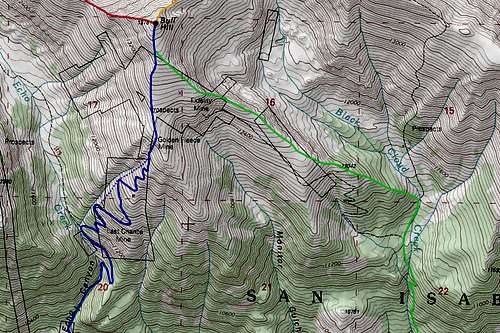 |
RED: Bull Hill/Casco Traverse - Class 2+
ORANGE: Bull Hill/South Elbert Traverse - Class 2
BLUE: Echo Canyon South Ridge Route - Class 2
GREEN: Black Cloud Trail Southeast Ridge Route - Class 2
Camping/Red Tape
Campsites abound in the Twin Lakes Recreation Area. The small township of Twin Lakes on CO-82 offers a few lodging options as well. There are no designated camping areas at either Black Cloud trailhead or Echo Canyon trailhead. However many suitable campsites can be found up and around both trails and in a handful of places along Highway 82. The area lies on National Forest Land. No permits or fees required. Just be careful to avoid private property surrounding the Echo Canyon Trailhead and stay on the trail for the first few minutes.