Bushwhack Heaven and Hell: The Tale of Two Summits
It is yet another pretty week of weather and I unfortunately have to work two jobs for all seven days of that week. All I can do is think about mountains like Sahale, Olympus and Glacier and wonder what might have been. But as for now I must stay patient and take what I can get. I invited my friend Josh Lewis down to stay for a couple of days to hike with my wife and I on separate trips, due to alternating work schedules. It was great seeing my wife hitting her highest point to date just the evening before and that served as great motivator for me to hike even when I when I am working two jobs.
Seymour Peak: A Touch of Heaven
The Mount Rainier area has been very good to me recently. This area is loaded with six and seven thousand foot scrambles with great killer views. Right now I know have just touch the tip with some of these beautiful mountains. Being on top of the beautiful Tahtlum Peak the week before I knew I had to get Seymour this upcoming time. For this trip I brought my friends Zephyr from NwHikers, Jordan and Josh Lewis for this hike.
We started out from Route 123 and decided to bushwhack the first section from the road up Dewey Creek. At first the bushwhack was quiet simple and the woods were thin enough to make good time through them. But from time to time the woods did get thicker and occasionally we had to go through some underbrush and some stream crossings. We all stuck together and slowly picked our way through the forest up to an open area with a view of one of the ridges that lead to Seymour Peak. There was a side creek that led right into the northern cirque valley of Seymour Peak.
Once we got to that creek we followed what was a faint boot-path that in places was still covered in snow. From there we continued up that boot-path up through the valley until we hit the northern large snowfield of Seymour Peak. Getting up to this point actually was a little easier than the first section because the woods became much more open than what they were before. Also on the way up we noticed a number of pretty waterfall from the melting snow higher on the peak.
![Climbing Up Seymour Peak]()
Once we got to the large snowfield (which normally this late in August we headed up to the snowfield to the edge of the Class 2 40-degree scree field. Zephyr and I put our helmets on and all of us decided to head up the mixed scree and snow field. Josh and Jordan headed up the rocky section while Zephyr and headed up the snowy section. The scree here was quite loose and hard to get a footing. However the snow was very firm if not a little too firm. I had to work in a couple of steps but we did quiet well getting to the ridge.
![Near the summit on top of the ridge]()
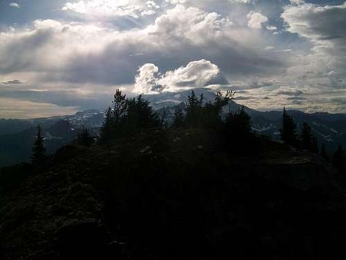
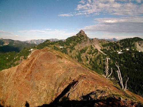
Once on the ridge we caught our breath a little and traverse the open ridge over to the true summit. The ridge was a little narrow but the exposer or not bad at all and soon we were on the true summit. As soon as we got there we saw the northern dome which though it was smaller it looked to have an even better view. From the true summit it looked like it might have been Class 3 or more but it looked worthwhile to take a shot. So Josh lead the way with Jordan and than Zephyr and I right behind. Josh soon found a good route and we quickly discovered that this scramble was only Class 2 with only some exposure. All of soon followed and we all made to the top of the northern dome where we all were able to take some pictures.
![Josh on the northern dome]()
![Looking at the Dewey and the other summit area]()
We could only stay up there for a little while because it was getting to be quiet late in the day. So once we took a couple of pictures we decided to head on back. We first went back over the true summit once again for some final summit shots. Zephyr broke out his awesome summit cookies and we were all in heaven. Anytime you have good views, good food, and good friends all at the same place you know you are in a good place. This time on Seymour truly fits all of that.
![The true summit]()
![Josh on the northern dome]()
But we knew that we had to rush off the mountain so we decided to head down. It was easier heading down the head-wall in the side snowfield I found this out the hard way because once I put my foot on the scree I slid down a little bit. But from there I quickly found the snowfield and followed in Josh's and Zephyr’s footsteps heading down the mountain through the snowfield. From there we continued down to the other snowfield where Jordan and I glissade about a hundred vertical feet and got to the edge of snowfield. From there we rediscovered an awesome boot-path down from Seymour Peak.
This sometimes faint boot-path or mixture of several boot-paths helped us head down the first part of the mountain quiet quickly. We knew the sun was starting to go down so using these boot-paths really helped us on our way down the mountain. The boot-paths lead us all of the way to the near the intersection of the creek heading up Seymour and Dewey Creek. There was also a very well defined boot-path that looked to lead all the way to Dewey Lake. I would not mind going to Dewey Creek and camping there sometime.
![Waterfall on the path down]()
But all good things must come to an end and the boot-paths finally disappeared roughly a half mile from the car. At that point we just had to pick ourselves through the woods all the way to the car. By this time it was really getting dark but we knew we were very close to the bottom of the road. Just when it was really getting dark we finally made it back to Route 123 where we were able to relax at the car and take in some safe journey and eat some of Zephyr's celebration cookies. It was a great day to be in the mountains and all of us were tired but very happy to be on such an awesome trip.
An UnBearable Bushwhack
Here is a trip that nearly did not happen and probably should have not happened. I woke up the next day from Seymour Peak and I was very tired and somewhat. Unfortunately it was yet another amazing day and I knew there only going be a few more of these left so that I better capitalize on this day. So when got back from work I rested a little and decided to go for BearScout Peak. BearScout was an I-90 peak and it was only 8 miles and 2200 of elevation gain. I knew there would some more bushwhacking but I did not expect to be any worse than Seymour Peak. Honest it probably would not have been except I took the wrong way up!!!
I was obviously determined for this mountain. When I reached the pullout for BearScout I was greeted by a guy would was practicing with his handgun. This is always a little unnerving but this is not a formal trail and there were no signs against it so I was cool with it. Me and Josh Lewis did tell the guy we were heading up and quickly realized that the guy was a nice guy and was very respectful of us. We got a good vibe and continued our quest for BearScout.
The ATV trail was a good quick start and we were able to get the first 1 down in less than 15 minutes. Once we got to the end of the road our true journey began. We quickly found what at first looked like a good trail or boot-path so we decided to follow the boot-path But this boot-path was easy to lose and we lost it quiet quickly and found ourselves traversing logs looking for the path. We continued to do this while heading towards BearScout Peak. This was obviously a bad omen for the rest of our trip. Finally we hit a stream bed and realized that the boot-path we lost was on the other side of the creek. We had then scramble from one side of the creek to the other with Josh leading the way here.
![Scout Lake with Granite in the distance]()
From there we found the boot-path that lead all of the way to Scout Lake. Scout Lake was a pleasant surprise and if this was the final destination it would a great little lake to stop at. But in order to get BearScout Peak I had two choices on how to head on up, either side traverse the scree surrounding the lake all the to the lowest point of the ridge and get the ridge there, or head straight up the steep slope to the ridge-line. Side traversing to the ridge-line was the correct answer. Unfortunately Josh and I picked going straight up the steep ridge. In winter 45 to 50 degrees of snow is really no problem heading up. In summer with loose soil, scree and thick devil club on a relatively (for Washington) humid evening this was pure hell.
At first we started up the talus. This talus was loose in places but though it was steep the handholds were clearly there. Unfortunately the nice talus quickly gave way to talus covered with devils club that became thicker the more we went up. The terrain got steep and quickly this was becoming no fun. Slowly we scrambled up the now smaller and lose scree again while the devils clubs was stabbing every exposed part of our body. We looked down and we realized we were beyond the point of no return. Add on that one of the branches ripped off my glasses and that the masquitos were eating us alive and for that one moment I thought we were in hell. We looked five minutes for the glasses but at this point it was a waste of time through the thick brush and we were in a dangerous area so the glasses were just going to have to be left behind
But it only got worse from there, the scree underneath turned to lose soil and the traction below our feet had become zero. We were literally hold on to vege belays (ie any branch we could find) and climbing up slowly one step at a time. Sweat was coming off me fast and furious and I was getting extremely tired very quickly. The mosquitoes were biting me at will and my leg were starting to cramp up from overheating. But I knew I had to get to the to the summit for possibly a better way back.
Finally Josh said the magically words that I will never forget. “Guess what Greg we made the ridge.”
I was so relieved knowing that I was on the ridge. Knowing that did not stop my now serious cramps from happening. Despite begin eaten alive by mosquitoes I had to take a break and drink some serious water. Once I recovered though we continued though slowly up to the summit.
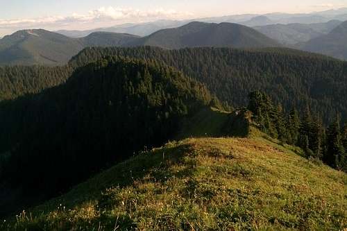
The last part of the trip up to the summit was not nearly so bad we walked across some beautiful open fields and a number of scree fields. These were very tame compared to the hell we were going through before. We stopped at the summit area and took in some excellent views. After ten minutes we decided to head down the western side of the mountain. After all anything was better than that other side.
![Silver from Bearscout]()
![Humpback and Kaleetan from Bearscout]()
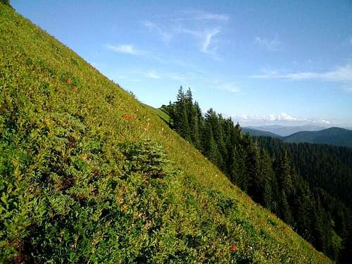
Lets just say at first heading down was much easier at first that heading up. We first had to drop down a very steep heather field but the heather was very health for being on a 45 degree slow. TO me honest I never knew of just a healthy field growing on that steep a slope. Then we reentered the forest. Going down the ridge we followed a boot-path that basically followed the no trespassing signs. Once we got to the lower part of the ridge we then bushwhack from that ridge on a semi-path down to the scree fields below. This part of the hike down was actually quiet pleasant. Even descending the scree was not too bad.
![Josh in the heather fields]()
![Steep heather field]()
Unfortunately yet again we were running out of sun quickly which made us try to speed up while heading down. This turned out to be a mistake because once again we found ourselves in some more obstacles. The devils club had returned and the only way to dodge it was to go over mossy logs and slippery logs. Otherwise it was going to time to get sliced up yet again. By this time I was tired and frustrated but I knew I had to remain cool to make it out of area intact. The mountain had already took my glasses. I wasn't going to have it take me as well.
So we traverse over the logs. They did help us avoid the terrible devil's club but the 12-15 foot drop-offs from the sometimes slippery logs did not exactly give me the most pleasant of thoughts. I knew one fall would be quiet serious in some of the area. But I had to keep marching on. Then just when total darkness happened Josh found the boot-path we were on earlier. We jumped for joy and quickly made our way out. But this boot-path had one more surprise. It disappeared again leaving us yet again to bushwhack through more devil's club and logs. Luckily it was only for a hundred feet because we found the path a final time and then headed on out.
One we hit the ATV trail we knew that we were golden on the way back. At least we were safe back to the car. But wait a minute now without my glasses and Josh not have his license how were we going to get home. This is where teamwork and smart driving has to take control. I knew vision was okay enough to see some things on the road but I also knew I going to need Josh's help to make sure that we made it back safe and sound. With some careful driving and some good navigation we made it home very safely without incident.
Overall this second trip to me was a bit of a failure. There is too much here that not only do don't either want to go through again but decisions that I don't want to repeat. I plan on having many adventures but not another one of these ever again. In the future if I am tired I will just wait another day. It was great to make it to summit and make it down okay but not the situations I ever want to go through again.
That being said I want to thank Josh for being on both of these great adventures and for being there for my wife. I am thankful to get to spend of time with my good friend and for us to bushwhack up some great mountains. I look forward to our big trip soon!!!
Comments
No comments posted yet.