Introduction
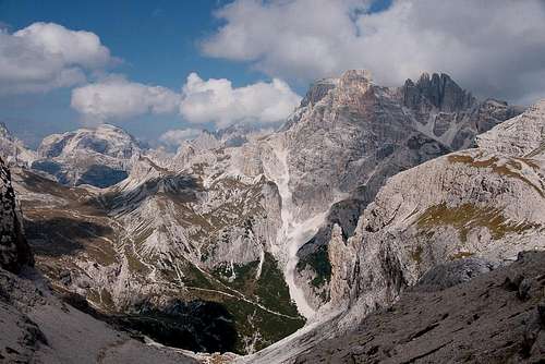
![The northern Sexten / Sesto Dolomites]() The northern Sexten / Sesto Dolomites as seen from Büllelejoch / Forcella Pian di Cengia The northern Sexten / Sesto Dolomites as seen from Büllelejoch / Forcella Pian di Cengia |
- Judith and I usually heed that warning as we enjoy to be on our own to take all the time I need or want. Clueless tourist crowds get on our nerves and serve as a perfect repellent. We don’t really avoid the places they flock to but nothing attracts us there. You won’t find us in
Zermatt or
Chamonix though undoubtedly there is a host of reasons why we should go there. On the other hand we don’t exactly avoid crowded places and on a regular basis we find ourselves joining the throng. Sometimes we even return for a second time like to the summit of
Teide on
Tenerife even though the crowds up there are among the worst you can find anywhere on this planet. Flip-floppers on the highest mountain of Spain – you get the idea…
There’s one other place – the plateau of
Drei Zinnen / Tre Cime – to which we keep returning. Like the
Cañadas del Teide the heart of the
Sexten / Sesto Dolomites is incredibly beautiful and impressive – though on a quite different level. Also it draws huge crowds, which - though not quite as ugly as on
Teide - are not far behind. This is the story of my last visit to the place but it requires a bit of preparation.
Ten Years Ago
![Paternkofel / Monte Paterno]() Paternkofel / Monte Paterno with the little chapel near Drei Zinnenhütte / Rifugio Locatelli
Paternkofel / Monte Paterno with the little chapel near Drei Zinnenhütte / Rifugio Locatelli
It was ten years ago, that I first set my eyes on
Drei Zinnen / Tre Cime. Of course I had seen pictures of the group and was eager to see them for myself but I had to learn that no picture – not even the best one – can prepare you for the real thing. None of the pics can tell you the scale - 1000m of vertical rock, multiplied by three. El Capitan proportions…
My own first
Drei Zinnen / Tre Cime experience was special as well. On a Sunday morning in September 1999 I hiked to the plateau through the
Rienz River Valley in the east. I was alone since Judith was having knee problems and preferred to drive to
Rifugio Auronzo on the southern base of the towers to join me on the plateau for the usual
Drei Zinnen / Tre Cime circle hike. During the two hours it took me to reach the plateau I only saw one person, another hiker, whom I overtook and who had the same destination as I. As I reached the plateau three oncoming hikers said something of culture shock, a remark I couldn’t directly understand. But as I paused to take the obligatory picture of the three giant north faces I noticed something weird in
Paternsattel / Forcella Lavaredo, the saddle to the east. I took out my binoculars and had a look: hundreds of people were literally queuing up for the circle hike – they seemed to march in step towards the next destination –
Drei Zinnen Hütte / Rifugio Locatelli.
Since this was also my own destination, where I would be joined by Judith, I slowly walked over. Judith was late – it turned out she had missed the
Misurina exit and driven on to
Cortina instead – and I had ample time to observe all facets of humanity in the stampede. I won’t go into details but tempers were flying, and on the upper trail, which runs through the scree slopes beneath the
Paternkofel / Monte Paterno west face, a whole group had become stuck because someone couldn’t take the exposure (which is minimal at this point) and held up the whole crowd. Finally Judith arrived and we set out to finish the circle, returning to where she had left the car. Beautiful as the hike was – all those people spoiled the experience and we decided to try again.
A few days later we returned, this time hiking from
Sexten / Sesto, taking the highly recommended (by our guidebooks) trail which circles the whole
Einser / Cima Una Group. Since it was a weekday and since we had started early we only occasionally met people – much more to our taste. The tour proved to be absolutely wonderful, especially in its first half. At
Drei Zinnenhütte / Rifugio Locatelli there were the usual crowds but not as many as there had been a few days before. During our descent to
Sexten / Sesto we discussed the tour and agreed that whenever we would return to the area we would also re-do this hike.
September 21st 2009
![Dreischusterspitze and Gsellknoten]() Dreischusterspitze / Punta dei Tre Scarperi and Gsellknoten / Cime di Sesto
Dreischusterspitze / Punta dei Tre Scarperi and Gsellknoten / Cime di Sesto
After some ten days of a very mixed kind of weather last night’s weather forecast had called for a beautiful day. As we get up in the morning and see a cloudless sky we immediately decide that today is the day to hike the loop around
Einser / Cima Una. The mountain is the westernmost mountain of the
Sexten / Sesto Sundial, a summit above which the sun will hover exactly at 1 p.m. each day. Our trip will take os into the heart of this sundial with
Zehner,
Elfer,
Zwölfer (10, 11, 12) sidelining our route.
During our early breakfast we decide to take the car to drive into
Fischleintal / Val Fiscalina. The valley parking lot is only 10km from our apartment but we want to avoid the four hours the hike would take in both directions. Instead we plan to rather spend quality time in the mountains. We quickly get ourselves ready and on our way. Thus we are at the parking lot around 7:30 a.m. Only the tops of the mountains are already bathed in sunshine. Here in the valley it is still dark and cold.
The first section follows the road into
Fischleintal / Val Fiscalina, where we get a first glimpse of the
Sexten / Sesto Sundial. Framed by
Elfer/ Cima Undici and
Einser / Cima Una, the valley offers a grand gap to view the majestic towers of
Zwölfer / Croda dei Toni. Our route will take us to the base of this fine formation. After a few hundred metres a hiking path turns off from the road and we head through a forest of pines of all sizes in the direction of
Talschlußhütte / Rifugio Fondo Valle, the mountain hut at the very end of the valley. Before we get the trail leads us to the desolation of the river bed. Enormous amounts of scree have been washed down from the mountains and now cover a width of several hundred metres. The river / creek remains invisible underneath returning from its underground path only at the very mouth of the valley.
![Einser / Cima Una]() Einser / Cima Una with Zwölfer / Croda dei Toni to the left
Einser / Cima Una with Zwölfer / Croda dei Toni to the left
For me the desolation is god-sent: For the first time the trees retreat far enough for me to see and photograph the impressive north face of
Einser / Cima Una. A few years ago the top of this mountain collapsed into the valley underneath, an event much discussed at the time. But I’ll return to this later. Due to the collapse some of the hiking trails underneath the north face have been closed and as we proceed on our loop we pass several closure signs. Here the flat part of today’s trip ends and we start winding up into the mountains.
Zsigmondi-Comici Hut
![Fischleintail / Val Fiscalina]() Fischleintail / Val Fiscalina
Fischleintail / Val Fiscalina
The path heads up the east slopes of
Einser / Cima Una and as we leave the trees behind, wonderful views open up in our backs. It is still quite early and most of the valley is still in deep shadows. Only the creek and riverbeds shimmer in white, thanks to the huge amounts of scree they have deposited. The northern
Sexten / Sesto Dolomites are already glistening in the intense sun and in the far background the
Carnic Alps Main Ridge and the
Villgraten Group of
Hohe Tauern can be beautifully seen. The day promises to be wonderful.
Soon we are underneath the vertical east face of
Einser / Cima Una and start to close in on the first destination the
Zsigmondi-Comici Hut. The landlord / keeper of the hut is the brother of the lady who own
s the pizzeria near the cable-car in
Sexten / Sesto. We have frequented her place quite often and she always urged us to visit her brother. However, she always gave us the latest weather conditions, which never were good enough to tempt us. But now we’re on our way.
As we get closer the ship’s prow like form of
Hochleist / La Lista comes into view. From our viewpoint it is barely conceivable that you can easily climb this tower from its back. From here it looks like the archetype of a Dolomite tower. The sun is finally rising across the
Elfer / Cima Undici Group in the east, blinding us with his oncoming light. We turn a corner and there it is – the north face of
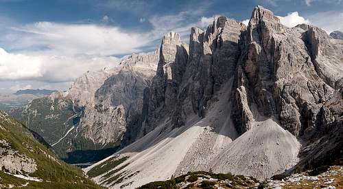
Zwölfer / Croda dei Toni. Its many towers loom above the cirque at its base, a stunning view.
![Zwölfer / Croda dei Toni]() Zwölfer / Croda dei Toni as seen from Zsigmondy Comici Hut
Zwölfer / Croda dei Toni as seen from Zsigmondy Comici Hut
Our trail passes to the west of
Hochleist and starts to wind towards the hut, which becomes visible up front. A short protected section guides across a short vertical section and suddenly we look across the deep valley we came towards the long ridge of
Elfer / Cima Undici. A few steps remain and we are at the hut. The few people we have met so far start posing in front of the hut before heading for the terrace to get their morning coffee. We take a few looks, then a drink from the water bottle and head on. We’re not here for having fun!
Karst!
![Karst]() Karst
Karst
The following section of the loop will lead us to
Büllelejochhütte / Rifugio Pian di Cengia. As we head up from
Zsigmondi-Comici Hut we realize that we are about to enter a wonderful karst region. This area must be wonderful in spring and early summer when the mountain flowers are blossoming. Today in September there are only patches of grass among the pale dolomite rocks. But together with the blue sky above it is stunningly beautiful. The area becomes a maze and but for the marked path one could easily get lost in here.
Still we are getting higher and higher and both
Elfer / Cima Undici and
Zwölfer / Croda dei Toni dominate the scenery.
Hochleist / La Lista, the tower that impressed us before, has turned into a low ridge, far underneath the
Elfer / Popera Group. In a saddle we come across a trail intersection. The oncoming trail is closed – it leads too close to the rockfall area of
Einser / Cima Una. But again, a wonderful karst plateau draws our attention.
We turn back and prepare for the climb to
Obernbachernjoch / Passo Fiscalino. When we reach it we get to the omnipresent WW I relics – old artillery positions and trenches – the first we see today. As usual, a via ferrata has been created from the old WW I support trails here but though it is a short one and it is still early we refrain from trying it. Instead we take the ledge trail which leads us to the hut. The views open to the west and south and for the first time today we look at the
Cadini di Misurina. A few more steps take us to the next saddle,
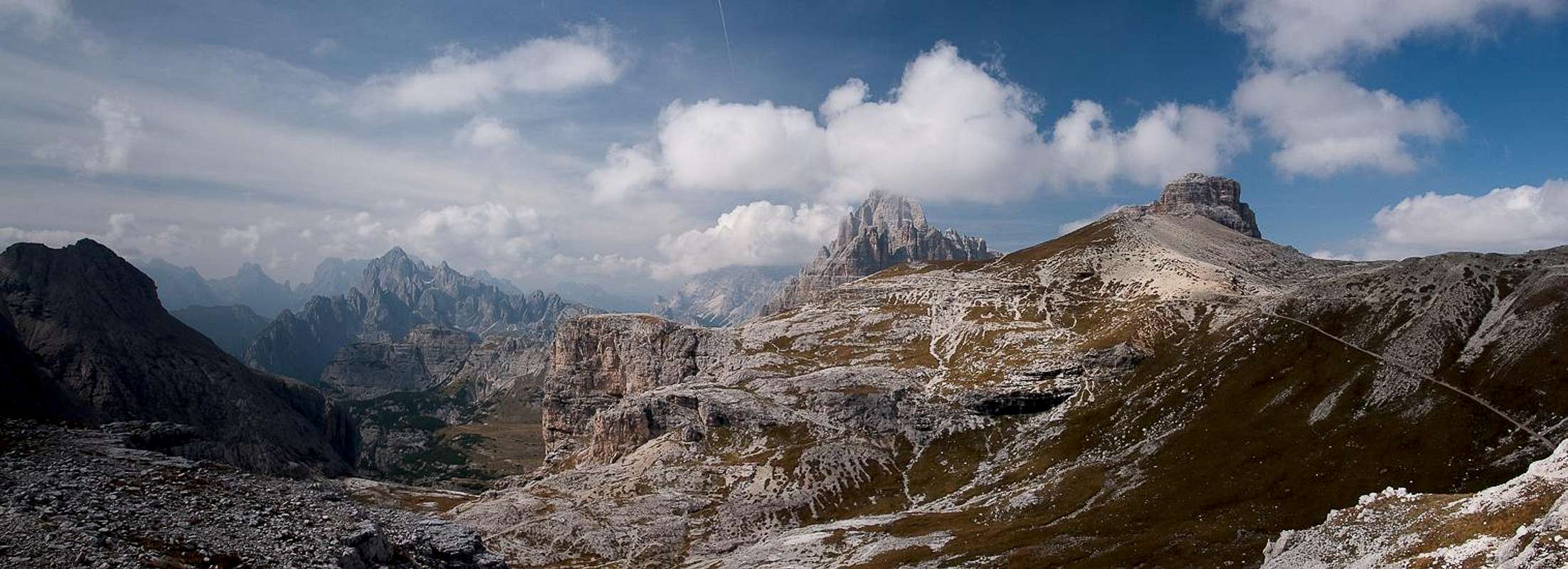
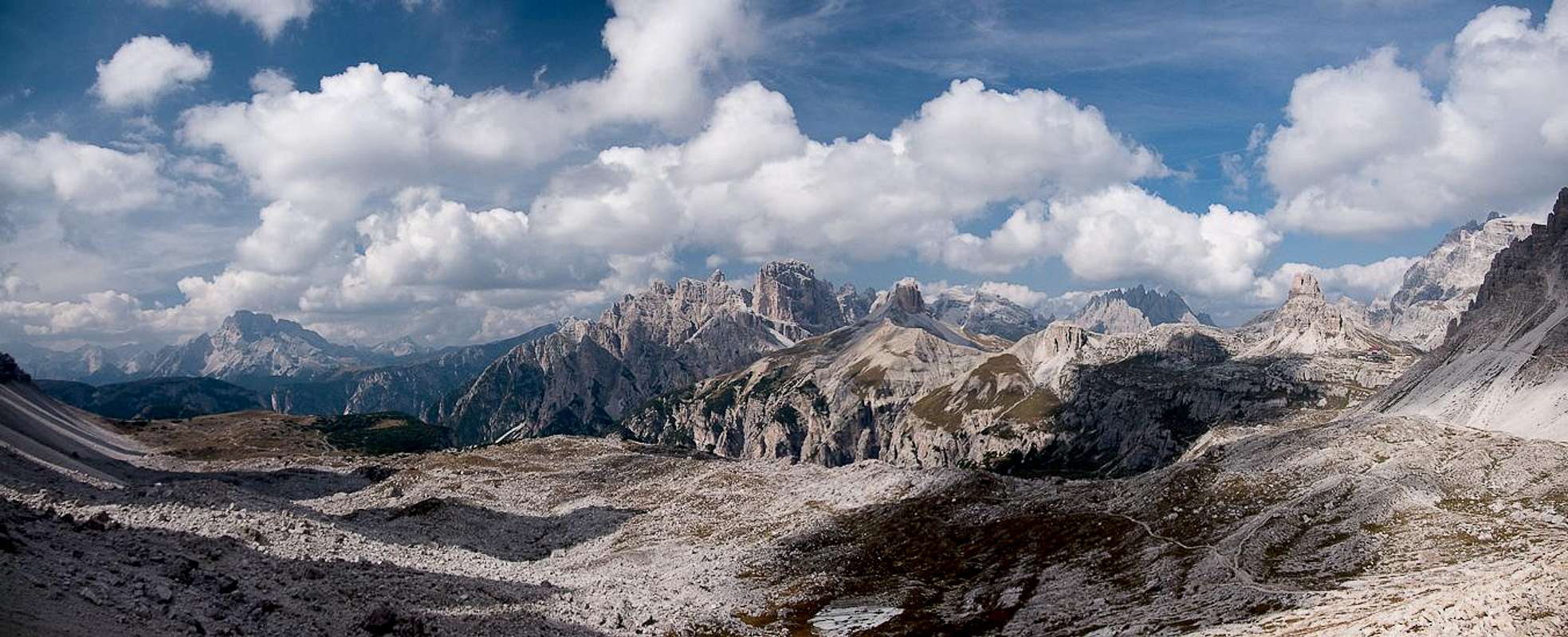
Büllelejoch / Forcella Pian di Cengia. Here we suddenly look across the northern
Sexten / Sesto Dolomites in all their beauty. The intended trail heads down underneath the north face of
Paternkofel / Monte Paterno and it seems like another half hour will take us to
Drei Zinnenhütte / Rifugio Locatelli.
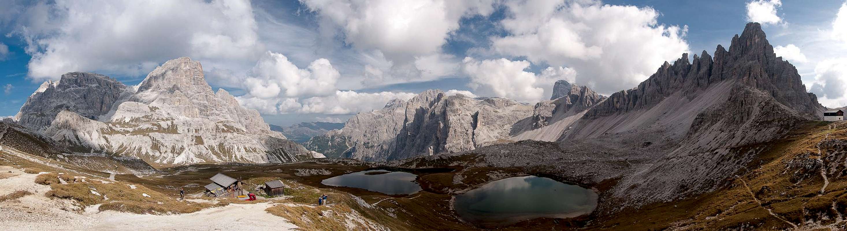
The view from Büllelejochhütte |
Since it is still only 11 a.m. I propose to extend the loop include
Passportenkopf / Croda Passaporto and
Paternkofel / Monte Paterno as well. There will be crowds but Judith agrees. But before continuing on our new route we take a break and I take a bunch of photos in all directions.
Laghi di Cengia / Lago di Lavaredo
The northern Sexten / Sesto Dolomites seen through Büllelejoch / Forcella Pian di Cengia |
The next part of the route follows a broad dirt road, which today serves as support road for
Büllelejochhütte / Rifugio Pian di Cengia. Old artillery positions at its side soon tell us about their origin – a WW I road built by Italian Alpini to accommodate the frontline which ran right across the
Paternkofel / Monte Paterno east ridge in our north. As expected, we finally meet oncoming hikers, most of them Germans. An Italian woman, however, addresses us, asking for the time to the next hut, and in my best (non-existent) Italian I explain to her that only 15 minutes are missing. She wonders if she should extend her hike to D
rei Zinnenhütte / Rifugio Locatelli and asks how far this would be. I answer that we didn’t come that way but that I’d expect her to arrive at the hut in about 2h. Thanking us she hurries to join her husband who has ambled along.
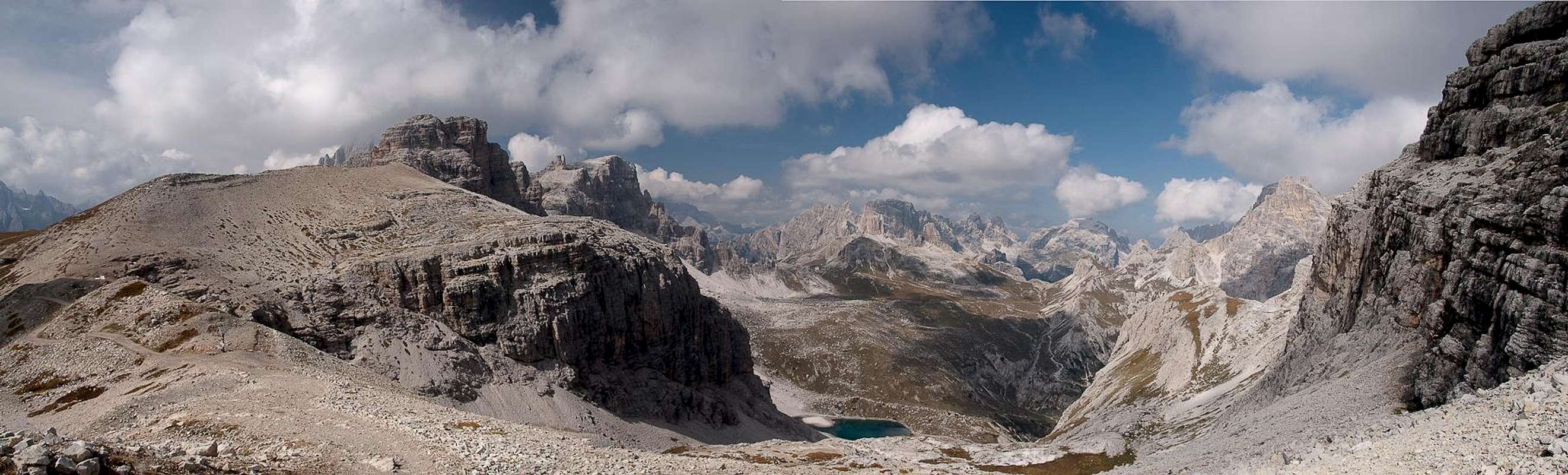
We now descend towards the
Laghi di Cengia, losing about 300m in elevation. Above the lakes
Drei Zinnen / Tre Cime make their entry and I hope for a mirror picture. Down at the lakes the towers have almost vanished from view but I snap a shot anyway. Judith impatiently hikes on and I hurry up to join her again. Still we descend and as we pass
Monte Cengia great views open up towards the south along the broad
Val di Cengia. The road heads down into the valley while our hiking trail leaves it, still heading westward. We look for a place to lunch and find one close to the path underneath the towering south face of
Passportenkofel / Croda Passaporto. Above us three towers loom in a good imitation of
Drei Zinnen / Tre Cime close by.
Unfortunately clouds have started to roll in and now they start obscuring the sun. It is still quite windy and the temperature drops immediately. We rush through our lunch and return to the trail. Now we are getting close to the
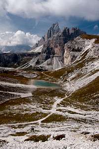
Lavaredo Plain, and the trail gets more and more crowded. It is a far cry from our 1999 experience but still more and more people come the other way. We ascend a narrow valley with little to see. At its end the trail winds out and suddenly we find ourselves on the
Lavaredo Plain. Right in front of us is
Lago Lavaredo, a small lake and beyond tower the mighty
Drei Zinnen / Tre Cime. Here I finally get my lake mirror picture and I’m happy. On
Kleinste Zinne / Cima Picolissima a climbing party is struggling halfway up and I wonder at their late start. It is 2 p.m. now and if they want to reach the top and safely return they sure need to kick into high gear.
The Tourist Routine
![Drei Zinnen / Tre Cime]() Drei Zinnen / Tre Cime from Paternsattel / Forca Lavaredo
Drei Zinnen / Tre Cime from Paternsattel / Forca Lavaredo
From the lake we scramble a few steps to reach another dirt road. Here we obviously enter touristland. The road connects
Rifugio Auronzo,
Rifugio Lavaredo and
Dreizinnenhütte / Rifugio Locatelli and here a large number of people are hiking. To the north-west an additional hiking path cuts short a large bend in the road and there also people are hiking. Their common destination is
Parternsattel / Forcella Lavaredo and as we nead to head there too, we join the crowds. Luckily we didn’t come here on a Sunday so that a minimum of privacy is still ensured. As we step into the saddle, however, we can’t help overhearing several conversations. One of them makes me want to scream:
The northern Sexten / Sesto Dolomites seen from Paternsattel / Forca Lavaredo |
1: “This is great isn’t it?”
2: “Wonderful!”
1: “I’m glad we came here!”
2: “Will you hike the loop around Drei Zinnen?”
1: “There is a loop?”
2: “Yes, go to the next hut and then return to the parking lot the other way. It takes three hours.”
1: “Oh, I don’t know, I think that’s too far!”
2: “Oh, come on! You’ll directly reach the parking lot!”
1: “Which parking lot?”
2: “Didn’t you come from the Rifugio?”
1: “No, we came all the way from Sexten”
2: “Oh my God! But there’s a parking lot right here! Didn’t you know that?”
I can’t take this anymore and run away. This way I didn’t hear the conclusion of the conversation but why should I? Obviously it never occurs to some people that you might walk through this beautiful landscape, exactly to enjoy the views. Shaking her head, Judith catches up with me and we head along. I propose to hike the narrow ledge trail underneath the
Paternkofel / Monte Paterno west face but Judith tells me she has had enough elevation gain today and that we should stay on the road. I’m ok with this, especially as most of the crowd have stopped at the saddle and return in their tracks.
The dirt road is a hiker’s highway and we quickly cross the plateau in direction of
Drei Zinnenhütte / Rifugio Locatelli. With every step we take the north faces of the famous towers get into better view until we are at the base of the platform on which the hut is built. There a number of caves indicate Austrian WW I positions and I scramble up to one to have a better look. The inside is littered with garbage of many generation but through the gap in its front you have a nice framed view towards
Drei Zinnen / Tre Cime. I return and we hike the last few metres to the hut.
As usual the hut is very busy. Coffee is served on its platform and endlessly people arrive and leave. Like a railroad station. We scramble up to the little chapel behind the hut, where we unpack and take a bit of a break. Immediately we are surrounded by alpine choughs begging for food. We haven’t even started eating yet! But it is cold and we quickly munch our apples, tossing them our leftovers. Ond now you can see what a choughfight is like! In the end the boss-chough takes the apple, puts a claw on it and each time one of its colleagues get close it spreads its wings across its bounty. What a din they make!
Einser / Cima Una
The panorama above Bödenseen / Laghi dei Piani |
Now we prepare for the descent through
Altensteiner Tal / Val Sassovecchio. I remember that ten years ago this part of the loop was a real drag. You go down for about 1000m on a deep rutted trail and there are big steps to take. Back in 1999 my knees hurt like hell in this passage – so much that I didn’t even care to look at my surroundings. Up here on the plateau everything is still under control. And since we have enough time we can tackle the descent slowly.
![Paternkofel / Monte Paterno]() Paternkofel / Monte Paterno
Paternkofel / Monte Paterno
The first break occurs even before we really started. From the hut we look across the valley which we will descend presently. It is a wonderful 180° panorama, starting at
Schusterplatte / Lastron dei Scarperi and ending at
Paternkofel / Monte Paterno. This latter mountain shows its many pinnacle east ridge from where we are and it is barely conceivable that you can reach the top by a normal via ferrata. The mountain saw heavy fighting during WW I and many caves and mines can be visited during the ascent.
![Einser / Cima Una and Obernbachernspitzen / Crode Fiscaline]() Einser / Cima Una and Obernbachernspitzen / Crode Fiscaline
Einser / Cima Una and Obernbachernspitzen / Crode Fiscaline
As we hike along, one mountain starts grabbing our attention.
Einser / Cima Una stands like a huge sentinel tower above the eastern end of the valley. Beside it to the west are the almost equally impressive
Oberbachernspitzen / Crode Fiscaline which form a compact group of multiple summits. Only
Einser / Cima Una is separated by a deep saddle. In October 2007a huge block of 100m x 20m x 30m broke off near the summit. While it fell it disintegrated into a huge cloud of dust, which for the next days covered the whole area. Though hikers had been in the area, nobody got hurt. Today, the missing block looks like a huge wound to the west of the summit. The whole area around the mountain has been closed as in the aftermath of the rockfall smaller blocks have also fallen, each time creating big clouds of dust. There is a good reason for those giant scree slopes beneath the mountain! Here's a
short video from Austrian TV.
As we hike along
Einser / Cima Una steps aside to reveal the long crest of
Elfer / Cima Undici. We finally close in on
Fischleintal / Val Fiscalina, plunging in the forests around
Talschlusshütte / Rifugio Fondo Valle. From there we take the hiking path out, hurrying quite a bit since the sun starts to set and it gets really cold. The crowds, which during the day stay in this valley, have already vanished, giving us the opportunity to enjoy the hike. Near the parking lot I take one last shot of the
Sexten / Sesto Sundial.
![The Sexten / Sesto Sundial]() The Sexten / Sesto Sundial
The Sexten / Sesto Sundial
I’m sure I will return!
Route Statistics
![Route Profile]() Route Profile
Route Profile


Comments
Post a Comment