
-
 5503 Hits
-
 72.08% Score
-
 2 Votes
|
|
Route |
|---|---|
|
|
28.29864°N / 16.83337°W |
|
|
Hiking |
|
|
Spring, Summer, Fall, Winter |
|
|
Most of a day |
|
|
Hike and bushwhack |
|
|
Overview
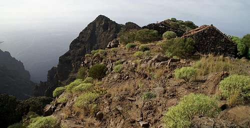
 Los Pajares from close to the trailhead Los Pajares from close to the trailhead |
In former times Camino de Guergues was the path which connected two or three farmhouses on the plateau of Lomo de tablada with the world. The farms were located so far from any civilization that in the meantime they have been given up and are falling into ruin. The trail, however, is still maintained, at least as far as the highest summit of the Los Pajares Ridge. Further west the trail is still well used and sometimes marked but after the last of the houses it turns into a bushwhack through gorse and Affodil. The route is rather a descent than an ascent, certainly after you passed the highpoint of the ridge, about 3km into the hike.
It pays to hike out to the cliff on the coast but it certainly is a hike with several difficulties. On all spots of this ridge traverse you have very impressive views, often the ridge is very exposed and in placed the underground is loose and slippery. Also, keep in mind that you will have to return the way you came which means ascending to Los Pajares. Often the heat on the plateau is stunning and you should bring large amounts of water.
Getting There
See the main page for the itineraries. The best starting point is a small parking lot at one of the first turns of the road which leads down from Degollada de Cherfe to Masca.Route Description
 Fincas de Guergues
- Start altitude: 950m
- Summit altitude: 1039m
- Cliff altitude: 508m
- Prevailing exposure: N and S
- Type: 3h one way (path is marked, rarely near the cliffs)
- Protection: None
From the parking lot at the mirrador walk down the road to the next (right) turn. There a path heads out towards the ridge of Los Pajares. Keep in mind to generally follow this direction, because there are marked paths turning left, towards the farmhouses near the road, the Casas de Araza. Try staying close to the ridge, you will soon see a path which heads out towards the rocks on the ridge.
Once on the path the next stage is rather easy to find. It follows the southern side of the ridge, sometimes passing exposed rocks and leading into the saddles in between. There is a gate, where the path turns away from the ridge, only to regain it by switchback further on up. Right beneath the Los Pajares main summit the path turns to the right side of the ridge and leads out into the north face of the summit. There is a turn and you'll head out on the plateau Lomo de Tablada to the south of the summit. A few unmarked steps lead you onto its top.
|


From the summit turn south until you reach the path by which you came. Now turn west and follow the clearly visible path across the plateau. There are several large steps, each following shortly after you passed by one of the ruined farmhouses. The final one of them, Finca de Guergues is located underneath a loose, overhanging summit, which leans into Barranco Seco to the right.
From the Finca you can either cross over to the other side of the plateau to look into the Masca Gorge or you can head on towards the coastal cliffs. For the latter pass the overhanging summit on its northern side (it can also be climbed but the rock is very loose and it might not be advisable. The path gets narrower, sometimes vanishing altogether. Moreover there are cairns, supposed to mark the path, but you'll find out that there are several sets of them, all leading in the same general direction. In the lower parts, i.e. when you already have gained the cliffs, orientation is much easier, facilitated by the fact that the bushes vanish the nearer you get to the coast. You might have to fight with ravens and / or seagulls for the best places to view the coast.
Return the same way you came.
|


