
|
|
Route |
|---|---|
|
|
40.95100°N / 113.784°W |
|
|
Hiking |
|
|
Spring, Fall, Winter |
|
|
Half a day |
|
|
Class 2 |
|
|
Approach
See the Getting There section on the main page for driving directions to the start of the 4WD Trail.Route Description
Round Trip Distance : 13 mi (measured from the start of 4WD Trail)Elevation Gain : 3300 ft (measured from the start of 4WD Trail)
Start of 4WD Trail: N 40.966 W 113.8839 (WGS 84)
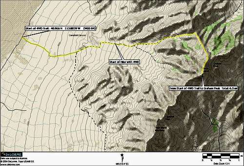 Hike Overview highlighted in yellow
 Route Up to the Saddle
 The Ridge to Graham Peak
To reach the start of the 4WD Trail, high clearance or 4WD is not needed. If you have 4WD or high clearance you will be able to drive about 3 miles up the 4WD road and save yourself 6 miles off the round trip and 900 feet of elevation gain, making it a 7 mile round trip and 2200 feet of elevation gain.
Once at the start of the 4WD trail begin driving or hiking to the east up the road which enters Campbell Canyon. The road is easy going just not recommend to those with low clearance. Graham Peak will soon be in a closer view. Continue up the road until you get close enough to head towards the small notch in the previous picture to the center left. The 4WD Trail will soon veer off to the south and doesn’t go where you want.
Continue heading east towards the saddle seen in this picture and gain the ridge that is in the background. You will soon have a better view of your objective. Once at this saddle (elev. 6200’) continue south along the ridge, Graham Peak is just over a mile away from here. Start scrambling along this ridge and soon the ridge will become narrower and more rugged but is kept at class 2 and there are no obstacles to go around, route finding is easy. You will soon be on the summit ridge. The small section right before the summit is the most rugged part of the hike but is kept at class 2.