Accumulative Elevation Gain: 34,185 feet / 10,420 meters
Distance Traveled On Foot: 75 miles / 120 kilometers
Introduction
A couple years ago I stumbled upon a trip report by SummitPost member PellucidWombat. Mark rode his bicycle across Canada bagging peaks all along the way (Trip Report). I was totally inspired that someone would have the nerve to take on an endurance adventure of such magnitude. The first result of my exposure to his story was that I rode my motorcycle down to Colorado and climbed one 14er every day for a week (Trip Report). But the impression he left on my psyche about the national parks in Canada and the beauty of the Canadian Rockies continued to haunt me. I couldn't get the area out of my mind. Furthermore, I knew that sooner than later I would have to see the area for myself.
Before Mark's report, all I had known about Banff was that it was some kind of ski resort area which annually produced the incredible traveling Banff Film Festival. When I saw Mark's photos of the Lake O'Hara area, I was completely floored. These must be some of the most gorgeous peaks in all of North America. Having spent years ogling mountain photos, I found that the pictures from this area were taking natural beauty to a new level. I wanted to see this area with my own eyes and climb some peaks while I was at it.
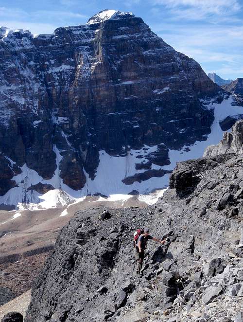
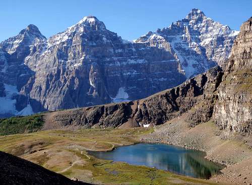
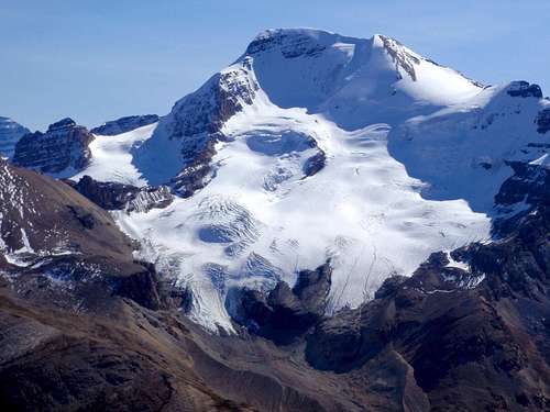
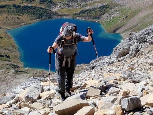
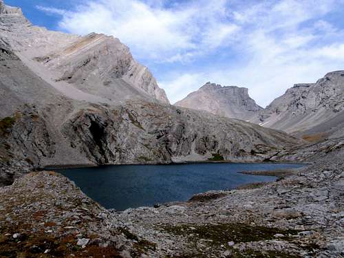
Uto Peak And Mount Sir Donald
In the summer of 2011, vacation time from work became a reality and I began planning. There would be four people in our group. I spent about 60 hours in research, online and reading books. I narrowed it down to 27 peaks. For each of these chosen peaks I printed up maps, detailed route descriptions, and photos. I figured that even though we wouldn't have time for all the peaks, it would be good to have a lot of options while we were there. For instance, if weather was bad in one area, peaks in the Kananaskis region were usually still dry.
Unfortunately two of my friends were forced to drop out of the trip due to some lame drama with their work. So now it would just be Maria and I. We purchased the only new piece of equipment we would need for the trip, industrial grade grizzly bear spray. Just as with my solo Colorado trip, we left town on my birthday. Coincidentally, this was also exactly one year to the day from when I had first met Maria, picking blueberries in a chance encounter while I was hiking with my sister. Several of my best hiking partners were discovered in this way, totally by chance.
Tunnel Mountain - 5551 feet / 1692 meters
We drove north after work on Friday and stayed with my family in Salmon Arm, BC on the banks of Shushwap Lake. The following day we drove through Glacier National Park on the way to Alberta. I was happy to finally see Canada's version of GNP. The peaks were towering precipices covered with a dusting of snow. The site looked like something in the Swiss Alps rather something in America. We came to Banff in the late afternoon after passing a great number of impressive peaks along the way. From my research, I was able to identify Grotto, Cascade, Rundle, and Temple. Temple was the main draw for me. Without it, this trip might not have happened. In 1894 it became the first of the 11,000 foot peak to be climbed in the Canadian Rockies. As far as I was concerned, If we could summit Temple, the trip was a success. All the other peaks were just an added bonus.
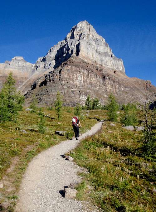
First View Of Mount Temple
Mount Rundle
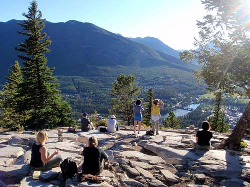
In Banff, the plan was to start with Tunnel Mountain, a kind of "Welcome to Alberta" hike. It was the late afternoon so we didn't have time for a big peak, but our trip had officially started, so we had to climb something right? Tunnel Mountain is located right on the edge of town. It’s like a Canadian version of Tiger Mountain near Seattle, short and sweet. We found what we thought was the trail but then about half way up we realized that it was some kind of direct route without any switchbacks. That suited us just fine. Near the top we intersected with the main trail which was busy with people. The views of downtown, and Mount Rundle towering above, were quite impressive. I had hoped to get a good shot of Cascade Mountain, which was our goal for the following day, but trees obscured views to the north.
Tunnel Mountain Summit
Back down on level ground we began the task of looking for a place to camp. Hotels and hostels in the greater surrounding area were prohibitively expensive. And why should we pay for an official campground with unnecessary amenities? All we needed was sleep. On these types of trips I prefer to find an out of the way place to sleep. With LNT, what difference does it make? During the entire trip, we only paid for lodging once, when there were no other alternative, and we both slept lousy that night. We vowed, never again.
Cascade Mountain - 9836 feet / 2998 meters
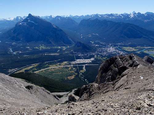
For our first big peak I selected Cascade Mountain which is one of the two downtown Banff Classics, Rundle being the other. We started early on our second day and made good time getting up to Cascade Amphitheater. Here several different spur trails cut up to the right, gaining the west ridge. We chose one spur and hiked up above the tree line. I saw a long ridge of peaks to the northwest, the Vermilion Range. It was amazing how the forest was so dense on these peaks and then ended suddenly with nothing above but grey-brown eroded rock. It was a unique pattern of these Canadian Rockies.
The Vermilion Range
The trail petered-out and we scrambled up some talus slopes, walking carefully on loose rocks. Following large cairns across the talus, we came around the corner and could see Banff down in the valley, along with surrounding peaks. Turning another corner, we came to the south face of the mountain. This face was steeper and consisted of numerous layers of down-sloping slabs covered with rubble. In a couple spots, the slabs were wet and there wasn't anything to hold onto, making passage tricky.
Cascade Amphitheater
Downclimbing one broken layer to reach another I came face to face with a seashell embedded in the rock. No way! All my childhood interest in minerals and fossils came flooding back in a torrent. I finished downclimbing and then completely forgot about the summit. Picking through the stones I found several shell specimens that would fit in my pockets. To think that we were near 9000 feet in the middle of the continent and I was collecting seashells. It was a mind-blower! Maria was very polite about my temporary lapse back to childhood but I heard her giggle a few times at my excitement.
Banff Down Below
After I collected myself (and enough specimens), we continued on our way up to the false summit. This was supposed to be the crux of the route. If we climbed too high, we would have to downclimb the false summit which was horribly exposed Class 4. The idea was to come up to it slightly lower and make an exposed traverse around the south side. This is what we did. Looking down into the southern gullies, I could see that a wrong move here would end very badly. Above the false summit we made a few scramble moves and then encountered our first snow. There was bad exposure to northwest as we were now climbing above the cliff walls of Cascade Amphitheater.
The Summit
It was getting cold and a little harder to breath too, an indicator of passing the 9000 foot mark. Our pace slowed but soon we were on the summit, in all it's windy glory. This was our first full-360-panoramic-view of Canadian Rocky peaks. We were impressed. The combination of dense green forest, wide open valleys, unspoiled lakes, and bare exposed rocky peaks made for an amazing view. Here we were, living the dream!
Lake Minnewanka
After a snack break, hunkered down in the shelter of the wind, we retraced our steps back down to Cascade Amphitheater and the parking lot at the ski area. We got back to the car late in the evening, with barely enough time to cook dinner before hitting the sack. We didn't know it yet, but this would become the pattern of the trip, rising early in the morning to rush to the mountains and returning late at night, exhausted and starving, falling asleep right after our dehydrated dinners. It took a lot of self-discipline each night to set the watch alarm, which would cut short our slumber.
Amazing Strata
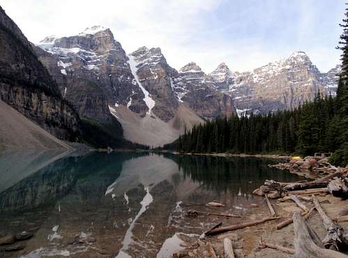
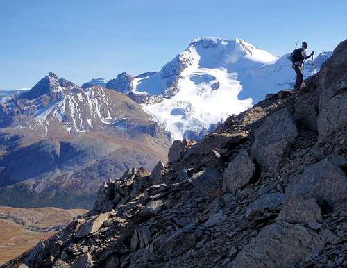
We agreed that we should climb Temple early in the trip, before we got too exhausted. With 5500 feet of gain, Temple would be our most grueling objective. It would also be our highest climb and most technically demanding route. But I wanted to have a good look at the route before we went for it, so we would know what to expect. Primarily I was concerned with how much snow was on the upper slopes. When we had driven into Banff the first day, we could see that a recent snow had covered all the peaks, which left us questioning the route on Temple. The best place to view the standard route on Temple is undoubtedly neighboring Eiffel Peak. So on our 3rd day in Alberta we drove to Moraine Lake and set out for the summit of Eiffel.
Eiffel Peak - 10,095 feet / 3077 meters
At the start of the trail, we were stopped by a sign in the middle of the path. We had been informed about this. Regulations with strict penalties had been enforced to protect hikers from the frequent dense Grizzly activity in the area. To pass through Larch Valley required being in a group of 4 or more, staying close together at all times. Now I was missing my friends Mike and Robbin more than ever. They should have been on this trip with us. Damn careers! We waiting at the trailhead hoping to find some folks to join up with. After 20 minutes, a couple of young climbers came along. These two young women were going for Mount Temple. We could pass through Larch Valley together and then go our separate ways.
Moraine Lake In The Morning
Grizzly Sign
We started up the trail with a brisk pace. After a half mile, the two girls didn't let up their pace. They had been talking amongst themselves about ice climbing and how Temple was only a good warm-up. Obviously they were super-fit. Maria and I exchanged a glance that said more than words. We couldn't keep up with these girls on the steep incline. So, if we slowed down, they would have to as well, or run the risk of heavy fines, right? We slowed down and the two girls faded into the trees up ahead. Shit! Now we were stuck with the double concern of grizzlies lurking about in Larch Valley and also sneaky rangers hiding in the bushes just waiting for us unsuspecting victims to come by.
Larch Valley And Mount Temple
Mount Fay
We talked about what we should do. We could wait in place for the next group to come along and join them. But I reasoned that once again our pace might not jive with theirs. So we went alone up the remainder of the slope above Moraine Lake and over the edge into Larch Valley. The small trees were dense and there were numerous intersecting trails, where it was obvious that large animals regularly passed by. We tried not to think about what kind of animals had made those trails. Obese ticket writing rangers? I think not. Before going above tree-line, we cut off the trail and crossed the creek heading for the southeast ridge of Eiffel Peak. As we came out of the trees we could see Eiffel, Pinnacle, and even the giant Temple. What a beautiful valley! I'd never seen anything quite like it in the Cascades. Not that this was better, just different, perhaps a bit more grand.
On The Southwest Ridge
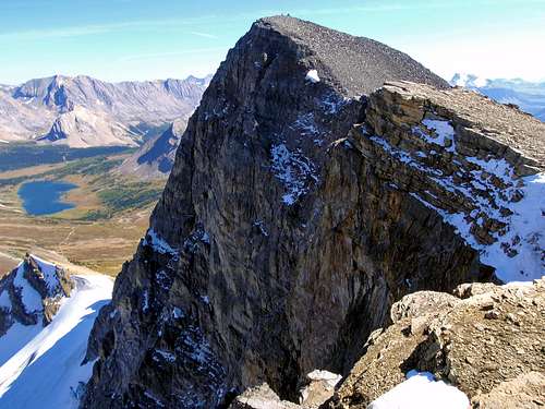
Deltaform Mountain
As we gained the southeast ridge of Eiffel we had views to the south and the Valley Of The Ten Peaks. Now here was a sight I would remember for the rest of my life. This long ridge of sharp, toothy peaks had a wonderful vertical relief, and the eroded niches and ledges, which were part of the geology, held portions of snow, warning of the harshness coming soon in the winter season. Below the peaks, the valley was strewn with moraines and broken, rocky carnage left over from the glaciers of ancient times. How I would love to explore that valley! What a pity that I'm so hung up on the summit thing.
Beginning The Scramble
Loose Rock
The incline of the ridge was gradual at first, but as we neared the bottom of the south face, it became steeper. We followed faint traces of braided boot paths up through some minor rock bands and then we came a major cliff band. So far we had ascended through several different colored geologic layers. This was one of the features that made climbing in this area so appealing. If all went as planned, we would be passing through these same geologic layers again the following day, on Mount Temple. In the middle of the large cliff band, there were a couple of steep notched gullies. We climbed up one of these, being careful of all the loose pebbles and ruble which made footholds precarious.
A Bit Of Exposure
A View Of Temple
Above the cliff band, the slope was steeper than before. I prepared to dodge some rocks kicked loose by climbers above, but thankfully the rocks flew by, far off to the side of us. Now I felt happy that we were both wearing helmets. There was one horribly loose section before reaching the summit ridge. It was hard to decide the best place to ascend. We took our time, not looking forward to the point when we would have to return this way.
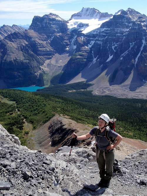
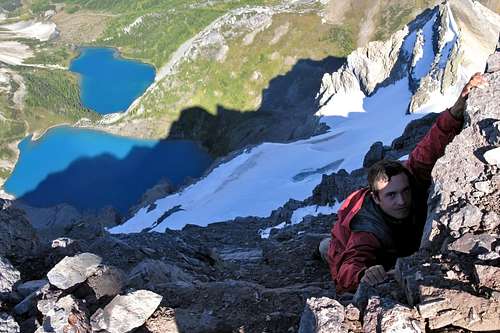
Maria On The Summit
Mount Hungabee
On the summit, I had to admit to myself, this was the best mountain view I had ever seen, by a long shot! We were surrounded by gnarly peaks, most of which were higher than us. Glaciers, jagged ridges, bright colored lakes, this was a wonderland display of the combined forces of nature and time. I could see the nearby side projection called Eiffel Tower for which Eiffel Peak was named. And there was Temple, in all its massive glory. I could see its famous gold band and also the grey band where the technical crux move was supposedly hidden. Above those layers, the summit slope, and a corniced ridge crest. There was a lot of snow on the upper slopes, but I could make out the switchback trail, which was reassuring. So it was decided, we would make our attempt on Temple the following morning.
Mount Lefroy And The Eiffel Tower
Moraine Lake At Dusk
The wind above 10,000 feet was chilly. We crouched behind the huge summit cairn and didn't stay very long. The descent passed quickly. I think we were both excited for the following day. For dinner I ate the one dehydrated meal with the highest carb-count. I drifted off to sleep pondering my obsession with Mount Temple, all the time I'd spent looking at pictures of it and reading accounts of the route. And to think, my own climb was now just a few hours away.
Mount Temple - 11,614 feet / 3540 meters
The alarm went off. It was dark. It was cold. Our legs were a little stiff. We had to fight with our sleeping bags a bit since they didn't want to let us go yet. Damned sleeping bags! Always trying to steal an early start. We drove to Moraine Lake arriving just before sunrise. Just as before, there were a lot of folks hanging around the lake, taking pictures in the predawn light. We made good time getting to Larch Valley, but this time we stayed on the trail all the way to Sentinel Pass. We passed some lovely tarns just below the pass. Above the pass, braided boot paths made their first assault on the southwest ridge.
Moraine Lake Again
Passing Below Pinnacle Mountain
A simple glance at the ridge made it hard to believe that there was a plausible way through the numerous cliff bands. I wondered how many attempts had been made on this peak before the mystery of the grey band was decoded. Would we be able to locate the secret passage? If so, nothing else should prevent us from reaching the top. We had our crampons and ice axes in case the snow at 11,000 feet proved to be icy and slick. A group of 5 young men with strong English accents passed by. I noticed that their clothing was inappropriate and that they only carried what I think of as city-backpacks. I asked one of them a few questions. He told me he was fighting a killer hangover from drinks on the plane. He explained that they had just landed after a long overnight flight from England, and now meant to climb Temple, hangovers and jet-lag be damned. I cringed at the thought of what they were attempting here, but I couldn't look down on their display of determination and passion for what I too considered to be an awesome mountain.
The English Men Below The First Cliff Band
Scary Loose Rock
We scrambled up the first short cliff band and came to a very nasty slope of steep rotten rock, covered in ball-bearing type pebbles. We ascended this slope with our hands on the ground for extra support. Should our feet slip out, at least we had an extra chance to prevent a fall. Right above us, I could see the grey band. It didn't look promising, but I didn't vocalize any doubts that might discourage Maria. This whole trip was highly ambitious for her, as most of her experience was in long-distance backpacking. As we came closer to the base of the cliff wall, I began scanning for the location of the scramble route.
Grey Band Crux Section
We found the base of the scramble section on the grey band. As if there were any doubts left, it was confirmed by a small arrow painted on the rocks, pointing up. I went first, finding the rock to be much more solid than the rest of the mountain, but very exposed. It was Class 3 for the most part with a few Class 4 moves thrown in for good measure. After 20 feet, the scramble let off onto a ledge. I could see that it continued on, above the ledge, but I waited for Maria to join me before going any further. She did fine getting up to where I was. Then I led the second half, which was only another 15 feet of vertical scrambling. When we got to the top, I asked Maria why she seemed so happy. She was literally beaming. She explained that while she loathed all the loose terrain we had covered so far in this trip, she actually felt quite comfortable on solid rock and had enjoyed every moment of it.
Top Of The Grey Band
Exposure In The Gold Band
Above the grey band we hiked over to the next obstacle, the gold band. This rock was not as exposed as the grey band but there were numerous steep sections covered with loose rubble. The route finding was not as clear-cut either. It looked as though you could go a number of different ways. Actually, it was quite fun choosing your line and seeing if it would go. I tried to memorize the way we had come through so we could descend in the same manner. Above the gold band, the slope opened up. It was not as steep as what we had come through. By this point we had passed several parties, sitting down, who were obviously not going to proceed any further.
In The Gold Band
More Gold Band Action
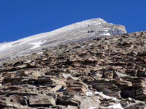
We continued to climb until we came to the crest of the southwest ridge. I was beginning to noticed the thin air and I felt that we were probably nearing the 11,000 foot mark. Suddenly, the final talus slope was in front of us. There were no further obstacles. It was amazing how much the snow had melted in only 24 hours. Yesterday, gazing over from Eiffel, we could see that this slope was mostly covered in snow, but now it was mostly bare. We wouldn't need axes or crampons at all. Our pace slowed considerably in the thin air. It took us nearly an hour to reach the summit ridge. We followed that north, being careful to avoid the cornice which was overhanging the east face. At the summit we used our axes for a victory shot. We had carried them all the way up here, so why not use them as props?
The Final Slope
Nearing The Summit
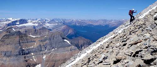
The view was farther reaching than that of Eiffel but not nearly as aesthetic. Standing on top of Temple, any remaining doubts about the trip just melted away. We spent 20 minutes peering down at the world below before we bid farewell to the summit and started down. We were able to find the same passage through the gold band, but downclimbing one spot proved to be much harder than we expected. Back at the grey band, Maria once again seemed unusually cheery and I knew it was because she loves solid rock.
The Corniced Summit Ridge
Nearly There
Success!
I had a different plan for our descent. I was hoping to save some time and I had noticed that in the middle of the southwest face, there was a long slash through the middle of the scree slopes. This was an indicator of many people over time taking an alternate descent route. None of the guidebooks mentioned descending this way, but if we could avoid some of the nasty slopes and all of the remaining scrambling, we would definitely save time. The gamble paid off and we bypassed Sentinel Pass, eventually rejoining the trail at the tarns. It was going to be another late night. We decided to pick an easier summit for the following day.
Allen, Tuzo, and Deltaform
Wenkchemna Peaks To The South
Cirque Peak - 9820 feet / 2993 meters
After looking at our list of peaks we chose Cirque because of its location on the Icefields Parkway. We agreed it was time to leave the Banff area and start our journey north to the Columbia Icefield. Before starting our hike, we stopped at Bow Lake to filter some water. From the lake shore I watched the first rays of sunlight illuminate the north peak of Crowfoot Mountain. What a sight!
Crowfoot Mountain
Bow Lake
Later in the day, It was amusing to discover that during the first few miles on foot, we had both been thinking the same thing, but not voicing it, "this looks like a pretty lame peak". But of course, any peak climbed the day after Temple is sure to disappoint. Actually it turned out to be much better than our first impression. We neared a creek crossing and stumbled upon a couple of busy marmots. One was gathering a clump of grasses in its mouth. It ran across the trail in front of us, dragging its booty back toward the hidden den.
Cirque Peak
The Approach
A Wary Marmot
Beyond the creek we came to Lake Helen where I spent a few minutes watching trout eating bugs from the surface of the water. When Maria caught up, we scrambled onto the south ridge. More loose rock. Maria was not happy. That's the real downside of the Rockies. To top it off, I had a horse fly take a special interest in me. If I swatted at him, he would back off for awhile, but then return as determined as ever. Finally I knocked him out of the air swinging my hat around wildly. I stomped him into the dirt before he had the chance to become airborne again. The damn things hurt when they bite!
Lake Helen
Loose Rock
Following the south ridge we came to the base of a steep talus slope. Near the top, a curved cliff band surrounded the whole summit block. I was curious about what we would find once we got to that point. It took a long time to ascend this particular talus slope. The extremely loose rock made progress very slow. With everything rolling downhill, I almost felt guilty for speeding up the decay of the mountain. Eventually we reached the base of the firmer rock, which had appeared as a cliff band from below. It wasn't completely vertical. One option would be to traverse along the base of it, to the right, but that looked fairly dangerous with all the exposure of the east face. We found an easy scramble up through the center of the band. When we came to the summit, we noticed a second summit nearby which was a little higher. We scrambled over to it.
Looking down on the north face below I could see the remnant of a glacier, but it appeared to be shrinking steadily. The peaks to the east looked very dry, almost desert like, but to the west, across the valley, we could see the massive Wapta Icefield. For the return, we descended down on the east side of the ridge, avoiding the loose exposed section which we had come up. On the east side of the ridge we passed some amazing rock formations. There were large thin slabs of glacier-cut limestone karst with deep fissures and cracks. This unusual formation is sometimes known as "limestone pavement". I picked a up few pieces, contemplating taking one home, but I settled for a photograph instead.
The Wapta Icefield To The West
We passed a very small tarn which appeared to be quite deep. I was so tempted to swim in this gorgeous little body of water. After so many days without a shower, it was somewhat maddening. But the water was just above freezing. So with the wind and all, I changed my mind.
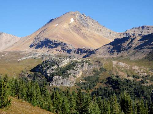
Mount Wilcox - 9462 feet / 2884 meters
Fatigue was beginning to make itself known to us. Each day we felt a little less fresh. Tiredness became a reality that touched every hour of each day. On the 6th day of the trip we drove further north to see the Columbia Icefield. This gigantic icefield is 125 square miles and is considered to be the hydro-graphic apex of North America. In other words, precipitation that falls there eventually drains out to three different oceans. And right behind the icefield visitor center is Mount Wilcox. With our fatigue we were trying to pick something easier and Wilcox only had 2835 feet of elevation gain. Unfortunately we greatly underestimated this peak.
Wilcox Pass
We headed up the Wilcox Pass Trail and then cut off onto the spur trail which was more direct. Crossing the alpine tundra gave me a feeling like we were in Alaska. The vegetation was definitely different in this area. Ground cover consisted of small hardy schrub plants, only a few inches tall. Even though the sun was shining, without any larger ground cover, this place had an endemic frigid appearance. Across the valley, we had inspiring views of Mount Athabasca and the Athabasca Glacier.
Mount Athabasca
The spur trail faded away but we could see Wilcox in front of us, so we continued hiking cross-country. We came to the base of the southeast ridge, which supposedly led all the way to the summit. We followed a boot path in an ascending traverse, near the ridge crest, until it ended amongst crumbly rocks. We were noticing an unusual amount of cairns built here and there, all over the place. It made me wonder how many tourists had wandered up this way. Who was responsible? We scrambled higher, staying near the crest of the ridge, just as my directions suggested.
Mount Wilcox
Then we hit the wall. In front of us was a nasty formation of loose rock. I spent 5 minutes exploring different ways of getting around it. None of them turned out to be good. After watching me, Maria told me she was done. The loose, exposed rock on this trip had been her biggest irritation. Looking at what might lie ahead, I totally supported her decision. She found a flat ledge and prepared to catch up on her rest.
Crumbly Rock
I saw something interesting below. There was an obvious boot path traversing across the face. I scrambled down to it and found that there was a cairn placed every 15 feet or so along this path. Also, this was much more traveled than the higher ground. I followed ledge path, trying to discern where it was heading. I could see a notch 300 yards ahead with a big cairn next to it. But following this trail meant cat-walking on some very thin ledges. The cairns reassured me. When I got to the notch things started to go wrong. The path ended, along with any sign of a route. Standing at the notch, I was looking down into a very steep couloir filled with loose rocks and dirt. The run-out was not good. I strained my eyes to see if there was anything on the other side of the gully. Nothing. Because of the steep walls of the couloir, it wasn't even possible to climb up on the far side.
High On Wilcox
Perhaps up is the right way? I carefully scrambled down into the couloir. Almost everything I disturbed, just let go, and tumbled down into the chute. I scrambled up about 10 feet, holding onto small indentations in the wall. I saw a snow patch above me on the left side of the couloir. There were some old boot prints in it. So someone else had come this way recently. But it didn't feel right. I turned around and got out of the couloir, heading back to Maria. Then I started to doubt my decision. Perhaps it got better above the snow patch? I turned back and this time I scrambled 20 feet higher than before, above the snow patch. The higher I went, the less there was to hold onto on the sidewalls. Above, I could see that the couloir turned into sheer flat down-sloping slabs. The summit appeared to be right above the top of the couloir.
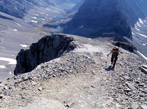
On The Southeast Ridge
Bullshit! Too dangerous. This could not be the standard route. I was pissed, feeling angry about wasted time and losing the summit, but even more heated about all those cairns I had followed. Some idiot out there was responsible for this mess and I would just love to give him a piece of my mind. I kicked down every last one of those bloody cairns on the way back to Maria. Watching the stones go flying and crashing down the mountainside made me feel better. It made a hell of a racket, which further placated my anger.
Don't Follow Evil Cairns
When I got back to her, she could see from the look on my face that I wasn't happy. Without asking any questions, she said "I'm sorry". But then she asked me about all the falling rock she had been hearing. I laughed, trying to decide whether to give up now or give it one more shot. Even though I knew the rocks near the top of the ridge were not good, they couldn't be as bad as what I had just done in the couloir. Even though my heart wasn't in it, I decided to give it one more try. I scrambled across some horrible Class 4 rock with several holds crumbling completely. Then it got easier again. There were a number of nice exposed ledges leading up to the false summit. From there I dropped down to a saddle where I looked down into the top of the same couloir. It was a death trap without rope. I quickly tagged the summit and went back to Maria. I was glad that I hadn't given up, but there were no fond feelings remaining for this peak. After a talk we decided to head back to the Banff and the Lake Louise areas.
Happy For 2 Dinners
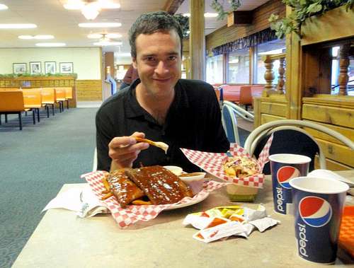
During the drive back, we stopped to eat at a cafeteria for the first real meal of the trip. We both spent over $35 dollars. I ordered two dinners; two racks of BBQ ribs with coleslaw, baked beans, and sweet potato fries, and also something called The Naughty Rabbi, a one pound frank buried under a half pound of pulled pork and coleslaw. Food!!!
Paget Peak - 8465 feet / 2580 meters
With my interest in fire lookouts, we had to visit Paget Peak. The Paget lookout was built in 1944 and is the oldest remaining mountain lookout in all the Canadian Parks. We found the obscure location of the trailhead behind a restaurant on the side of the highway. Following the trail through the trees, we passed one fork leading down to Sherbrooke Lake. The lookout itself was not located on the summit. We found that the exterior was in very good shape and it appeared to have gotten a new roof recently. To the south, we could see the valley of the famous Lake O'Hara, but we could not see the lake itself. Both walls of the valley rose up dramatically until they reached peaks which were 10,000 and 11,000 feet high. My interest in the Lake O'Hara area was now fully piqued.
The Fire Lookout
Beyond the lookout, the trail led to a loose talus slope. When we reached the top of that, we found we were at the bottom of another loose talus slope, this one twice as large as the previous one. We took aim for what looked like the summit and reached that point in just under an hour. When we got there, we could see the summit. It wasn't far away. Some minor scrambling should have us there in a matter of minutes. When we got to the summit, we could see that it was actually another false summit. Are you kidding? How many false summits does this peak have? It was actually funny because it was getting to the point of being ridiculous. We downclimbed an exposed step and then walked over to the true summit. And this time IT WAS the actual summit.
The South Summit
Looking to the north, we could see the ridge continued on, to a higher point, but much farther away, part of a different peak. It looked like you could just keep running ridges for days and days until you came to the high plateaus to the north, riddled with glaciers and icefields. I wanted to do that. Author Wade Davis once said something to the effect of, if you want to be happy with your life, you should stay at home, because if you travel and see the world, you're going to want a lot more of it. This can lead to dissatisfaction with your home life and eventually even disillusionment. I couldn't agree more.
Sherbrooke Lake
Descending from the summit, past all of those false summits, we came into a bit of trouble. Dropping below the tree line, we knew that the lookout was nearby but we couldn't find it. There were a lot of little spur trails around the vicinity of the lookout and we explored several of these knowing that the main trail terminated at the lookout. We backtracked and tried again but we could not see the lookout through the trees. I decided to turn on my GPS for the first time in the trip. It had been with us on all the peaks so far, but I only use it in situations like this one. I was now grateful that I had spent several hours figuring out how to download and install the free IbycusTopo maps. The lookout was not indicated on the map, but it did indicate that we were below the end of the main trail. According to the map, we should be able to drop down another couple hundred feet and intersect the trail.
Lake Louise Peaks To The South
So we did that, bushwhacking through minor rock bands. The slope got steeper and looked even more unfamiliar than before. WTF? According to my GPS we were standing on the trail. We looked around carefully, there was definitely no trail in sight. Crap! The trail on the map was just an approximation and nothing exact. I've encountered that before with maps. I should have known better. This meant we would have to climb back up above tree line and start all over from the beginning. It was hot. We were out of water, and none too happy either. There was only one thing funny about it. Each and every day we had mused about how today might be the day in which we would get down early and have time to relax a bit rather than rushing to cook dinner in the dark and immediately crashing afterward. I had sworn that today was going to be the day. I had even promised Maria. Paget was an easy trail hike. What could possibly go wrong? Well… This. The phrase "we're going to be down by 4pm today" became an inside joke between us, and whenever I said it, we knew that it was not true.
After a half hour of bumbling around, we made it above tree line and successfully found our way to the lookout. From there, it was an easy trail hike, but we had lost our precious chillax time once again, and it would be another late night, preparing for the following day.
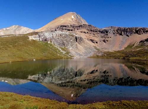
Ptarmigan Peak - 10,036 feet / 3059 meters
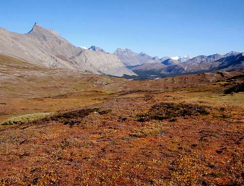
During my studies for the trip, I found rumors that the Skoki area of Lake Louise was exceptionally beautiful. Furthermore it's seldom visited due to the restricted access. We found restricted access to be the upside and the downside of the Skoki area. We didn't see another soul all day, but we did have to face the 2.5-mile road walk before coming to the start of the actual trail.
Richardson, Pika, Ptarmigan
Mount Richardson
Ptarmigan Peak
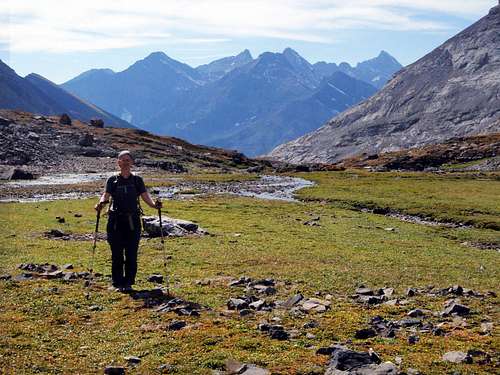
A cold breeze chilled us on the road and we were in shade all morning long. This actually helped us keep a brisk pace in an attempt to stay warm. We reached the historic log cabin in the meadow between Mount Richardson and Redoubt Mountain. During most of the approach hike, Mount Temple was visible to the south, looming over our shoulder like an old friend. The views of Richardson, Pika, Ptarmigan, and Redoubt were also improving from this vantage.
Above Hidden Lake
Lake Silhouette
Beyond the cabin, we left the trail which was going to Ptarmigan Lake and cut into the trees, following small stream beds to stay out of the thick brush. We were aiming for a minor protruding ridge, coming off the south side of Ptarmigan Peak. In the forest, we found many different variations of Castilleja paintbrush flowers. In the northwest I have only seen red and orange but here there were white, green, pink and purple ones. It was a neat discovery.
Upper Ptarmigan
Zigadenus and Myosotis Lakes (Skoki Lakes)
Rising above the forest, we came upon open grassy slopes, which gave way to loose gravel and talus higher up. The south face was a maze of cliffs and broken ridges. But there was a constant slope, far west of the summit, which went all the way to the top of the west ridge. We climbed this slope, only rarely needing to use our hands. As we went higher, we suddenly had a nice view of Hidden Lake down behind us. It was a pretty sight. When we came to the top of the west ridge, we could see Skoki Lakes, down on the north side. These two lakes had some unusual names, Zigadenus and Myosotis, which I later found out are the names of flowers. We could also see some big peaks to the north and east. On the other side of Skoki Lakes stood the formation known as the Wall Of Jericho.
The North Face And Summit
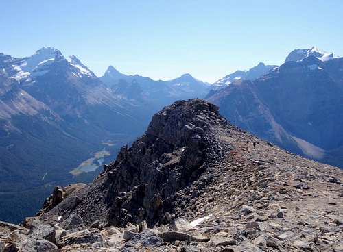
Finally we could see the summit, with two large cairns sticking up. It was not far away. To get there we had to scramble down into a notch in the ridge, which had considerable exposure on either side. At least the rock there proved firmly. Beyond the notch, we walked the remainder of the way up loose talus to the summit. What a view! And the route had been fun and interesting too. This was definitely one of our favorite peaks of the trip. I found a register that had been placed in 2005. Then we noticed the telltale signs of swirling smoke to the northeast. We watched it grow in a giant mushroom cloud and then die down again over a period of 20 minutes. I later learned that this was a "prescribed burn" in the Scalp Creek drainage. I found myself hoping to return to this area for some of the other peaks we were looking at.
Hanging On The North Face
As Maria was preparing to go, she had her back turned to me. Looking down the northern cliff face I saw a small ledge, a few feet down. I quickly lowered myself onto it so that when she turned around, only my head was sticking up above the edge of the cliff. She said "oh, that's horrible". I assured her that I was quite safe and asked her to take a couple of pictures. After that, it was a long way back to the car. We past a covey of 8 Ptarmigan in the talus slopes on the way back to the forest. They thought if they held still we couldn't see them. Funny birds. We made a short detour over to see Ptarmigan Lake before heading out. Dusk was setting in by the time we got down.
Ptarmigan Peak And Lake
Mount Temple Seen From Skoki Lakes Area
The Fortress - 9843 feet / 3000 meters
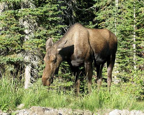
We didn't know it yet, but this was to be our last hike. Originally we had chosen nearby Mount Chester since it was the favorite hike of the author of one of my guidebooks, Alan Kane. On our drive into the Kananaskis area, we passed a moose on the road. It was eating grass along the perimeter and had absolutely no interest in us whatsoever. We stopped the car to take a couple photographs through the window. At the trailhead, we encountered our second "you shall not pass" sign. This time it said that nobody was allowed to enter the Chester Lake Basin, no matter how large the party. High levels of grizzly activity had recently been reported, some kind of Autumn feeding frenzy. Now my list of alternative peaks came in handy. We decided to tackle Chester and/or The Fortress from the next valley over.
Moose
As it turned out, we weren't able to locate the junction for the southern approach to Chester, so we aimed for The Fortress instead. This route was considerably longer than the Mount Chester route would have been. "We'll be down by 4pm today, right?". We had some road walking to do and then just as I was thinking we must have missed the cutoff, we found the trail. This trail was primarily used for fishing access to the Headwall Lakes. The deep valley was pleasant to hike through and we came to one steep section before the first lake.
Headwall Lakes
It was quite windy at the lakes and I began wondering if the weather might be turning. So far we had encountered the most wonderful weather. It was really unbelievable. In most of the summit registers so far, I had read entries from June, July and August in which hikers reported rain, snow, and no view. I honestly felt bad for those other hikers. Even one of our guidebooks said this about the Columbia Icefield area: "If you're visiting this area and it's clear enough to see anything, consider yourself blessed". And we hadn't seen a single substantial cloud until today.
A Small Valley
Beyond the lakes, we passed through a narrow section of the valley bottom and entered a broad flat area that was covered with short grasses, and what looked like peat moss. There was a sort of enchanted vibe to the small grass flats with steep bare rock walls on either side. We reached the head of the flats. Above us, loose talus slopes separated us from the southwest ridge. But then Maria spotted something that stopped me dead in my tracks. A trilobite! She probably thought "here we go again". I soon became extremely absorbed in the rocks on the ground, all thoughts of the summit temporarily gone. I spent the next 15 minutes poking around, putting specimens in my pockets. I even found one shard of stone that had dozens of shells embedded in it. I strapped that onto the back of my little day pack and then we carried on.
The Southwest Ridge
We gained the southwest ridge and it slowly became apparent that the summit block, which was in view, was much further away than it appeared. The wind was racing around us now. Our powerful fatigue made progress slow. We reached the base of the summit block and traversed around the left side to the base of the final scramble. It was short and somewhat exposed, but very enjoyable. The view of Mount Assiniboine (by now we had nicknamed this peak A-Cinnabon because neither of us knew how to pronounce it) from the summit was even better than the view from Cascade Mountain. There was no summit register but I did find a geocache. Inside were an assortment of strange items and a card which explained that I was free to take something so long as I left something else behind. I chose the honey roasted peanuts "best by 2009" and left some of my chocolate covered granola. The peanuts were still good!
Maria Scrambling On The Summit Block
It was near 3pm when we left the summit. "We'll be down by 4pm today, right?". Not! The Kananaskis interested me. I had heard that this is where local Albertans went to hike during the summer, to get away from the crowds. I plan to return there some day. As we descended into the valley, the force of the wind increased. The clouds were thickening up and they took on a threatening appearance. The summit was now covered over, out of sight. We descended as fast as we could, but didn't get back to the car until dusk.
The Summit
Back at the parking lot, we cooked up our gnarly dehydrated meals, eating them while sitting in the car. After dinner, I left the car to go filter water for the following day, at a nearby stream. It was fully dark now. As I approached the stream, I heard branches breaking and bushes thrashing directly uphill from me. Something was causing a ruckus up there, 25 feet away. I could tell from the sound that this was a large animal, not a deer, something more bulky. Had we attracted a bear by the smell of cooking our food? It could have been another moose, but I'll never know for sure because I hopped back in the car so fast. We drove out of there lickety-split.
The following day we were all hiked out. I decided to surprise Maria with an alternative idea. How about a visit to the downtown hot springs, and then some all-you-can-eat sushi afterward? She didn't put up any protest to that idea. The hot water was like a gift from the gods. I was the only one that got fully nude in the men's shower room, rather than just rinsing off in my shorts. 9 days without a shower is long enough. I was ready to make to full use of the facilities. At the sushi joint, they politely informed me that I had "timed-out" after an hour and a half, and somewhere between 70 and 80 pieces. Ha!
One Last Attempt
On day 11 we prepared to catch the bus to Lake O'Hara in hopes of tackling Mount Yukness. The O'Hara area is one of the most sought after hiking destinations in the Canadian Rockies, and for good reason too. It's stunningly gorgeous. But we had gotten word that the weather was in fact changing now. Bus reservations for Lake O'Hara are often booked months in advance, if not years in advance (no joke). We gathered along with about 20 other people that were hoping that one of the seats would open up. Honestly, we knew the trip was over, but we just weren't ready to admit it. Not at least without a one last attempt. It's possible to hike the 7.5 miles up to the lake, but with the probability of bad weather coming in, who wants to do that?
When the bus left without us in it, we took the car back out onto the highway, heading for British Columbia and then Washington State. We were going home.
Thanks for all the info you sent. Wish you could have been to the gathering. Can't wait to see your CA trip report. Really like this one too. Should be heading there this summer.
Matt, I hear you are in town. We should get together for a climb. We were actually climbing Wheeler Peak in Nevada on the day of the get together. Thanks for the compliment.
I'd love to join in on a climb but I got a job over xmas break in Colorado so I'm heading back today, after only being home for 4 days. I'm taking the summer off and plan on climbing throughout the continent. I'll be back in WA sometime in late July and early August. Lots of bigger mountains over the continent are on my plans for this year...I'll stay in contact especially when I am back in WA. The North Cascades are my next WA destination.
For someone so versed in the loose rubble of the Rockies, I think you would really excel in this area. I hope you have the chance to check it out.
Adam
It truly was. The hardest thing about a trip like this is going back home when it's all over and done with. I'm usually daydreaming about my next trip before I even walk in my front door. Thanks!
You've had a killer year, if one that many people would like to do in a lifetime. Aconcagua, Bonanza, the Canadian Rockies, Bolivia, Mount Olympus, Whitney and many other big name mountains. Cheer to 2012 and a shot at Nepal!
Thank you for such a great TR. The photos are excellent and it makes me even more want to get there one day. What a memorable trip, you really make the viewer feel there with you.
Children refers to the set of objects that logically fall under a given object. For example, the
Aconcagua mountain page is a child of the 'Aconcagua Group' and the 'Seven Summits.' The
Aconcagua mountain itself has many routes, photos, and trip reports as children.
Parents refers to a larger category under which an object falls. For example, theAconcagua mountain page has the 'Aconcagua Group' and the 'Seven Summits' asparents and is a parent itself to many routes, photos, and Trip Reports.


Comments
Post a Comment