
-
 8680 Hits
-
 84.27% Score
-
 18 Votes
|
|
Mountain/Rock |
|---|---|
|
|
0.19407°S / 78.46858°W |
|
|
Hiking, Trad Climbing, Sport Climbing, Toprope, Bouldering, Scrambling |
|
|
Spring, Summer, Fall, Winter |
|
|
9350 ft / 2850 m |
|
|
Overview

Las Canteras upper slabs as seen from the old highway to Tumbaco.
At the moment there are eleven fairly spaced bolted routes with fixed
anchors at the top of each rock slab. A perfect area for hiking, trad
climbing, sport climbing, toprope, bouldering and scrambling.
It is a very accessible area with lots of routes and cracks to choose from, as well as great views of the Cordilleras Oriental and Occidental and its highest elevations such as Cayambe, Antisana, Cotopaxi and Rucu Pichincha with Quito’s skyscrapers at its foothills.
The views of the historic neighborhood of Guapulo and its Sanctuary built in 1644, and located right across the almost 300-meter-deep-cliff below Quebrada El Baran are magnificent. A nice feeling while you are climbing because it gives you a sense of climbing at very high altitude.
Getting There

Quito and Las Canteras map.
The other way of getting to Las Canteras is walking. The trailhead is located right at the tunnels entrance. Climb the stairways onto the tunnels and follow an obvious dirt trail for about 5 minutes. It becomes into a paved road shortly for a while and turns into a dirt trail once again soon after. Down climb a set of metal stairs until getting to the old highway to Tumbaco.
There’s a deep cliff to the right side (Quebrada El Baran), so it is advisable to keep yourself the closest possible to the hill’s side in order to prevent a fall. Las Canteras can be seen in the distance as soon as you exit the last metal stairway.
 |  |  |  |  |  |  |


Route Description
Lower Slab. Crag 1.
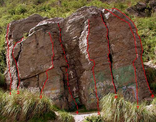
Lower Slab. Crag 1.
Route 1High-angle wall. Features several narrow flat rock shelves. YDS Degree Rating: 5.11a
Route 2Easy crack, good for jamming. Friends # 2 and # 3. YDS Degree Rating: 5.9
Route 3Vertical wall with narrow shelves. Moderate difficulty. YDS Degree Rating: 5.10c
Route 4Inner crack. Great for classic climbing with the use of a rack of nuts and friends # 2 and # 3. YDS Degree Rating: 5.9
Route 5Vertical wall, good for feet technique. Features narrow shelves. YDS Degree Rating: 5.10c
Route 6Easy crack, good for free climbing by jamming the hands and feet into the cracks and pulling upward. YDS Degree Rating: 5.9
Route 7Full of rock shelves, ideal for feet and hands techniques. YDS Degree Rating: 5.7
Route 8Wall with moderate inclination. Ideal for leading techniques. YDS Degree Rating: 5.10a
Upper Slabs. Crags 2 and 3.

Upper Slabs. Crags 2 and 3.
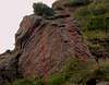
Crag 2.
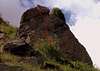
Crag 3.
Route 9The hardest of the routes. It has a wide overhang projecting out below the top. YDS Degree Rating: 6.11b
Route 10Located at the right side of route # 9. Great for beginners. YDS Degree Rating: 5.9
Route 11Vertical wall. It has a narrow overhang, easy to negotiate. YDS Degree Rating: 5.10a
Essential gear
Usually, a few slings, carabiners, nuts, three quickdraws and a 50-meter rope will suffice for all the routes.The routes are bolted and the anchoring systems on top of each slab are very well placed for setting climbing protection or top roping.
Red Tape
- You should take the gravel road towards the crags right after exiting the tunnels. In order to do so, pull over to your right side and back up by the gravel road.Traffic on this highway runs pretty fast therefore it'll be easy to cause an accident if you stop suddently. If you miss the gravel road you should get ready to pay USD. 0,40 at the tunnel's toll gate which is located 100 meters beyond.
- Not parking permits or fees.
- No water available near the climbing area. Bring water and insect repellent.
- Beware of the big dog at the western trailhead's entrance. Always ask the guard to leash the dog before you get in.
- Caution: A couple landslides have occured during the April month (2011). The trail (cliffs) is getting very exposed. This area is getting unsafe too due to robberies. It's advisable to visit this area on weekends when you'll find more climbers. Use the eastern tunnel entrance to get to the trailhead. Hitchiking at both tunnel's entrances is easy.
Camping
Due to the proximity to Quito, camping at Las Canteras is not advisable.External Links
www.monodedo.comOther helpful information
Guide books:- Ecuador, Climbing and Hiking Guide. Rob Rachowiecki and Mark Thurber. (6th Edition). Aug. 2008.
- Ecuador & the Galapagos Islands. Regis St Louis, Lucy Burningham, Aimee Dowl, Michael Grosberg. (8th Edition). Aug. 2009.
weshelor - Aug 30, 2011 4:19 am - Hasn't voted
Canteras, QuitoNo longer able to walk from Quito, to Canteras. Seriously washed away last spring, but passable; as of August, 2011, no one can pass on the old road, a 600 foot shear drop. Probably will not be repaired. Must drive to the east end of the tunnel. It is possible to walk thru the tunnel, small walkway protected by guard rails, but a mile of car fumes is not much fun.
Boriss Andean - Aug 30, 2011 10:32 am - Hasn't voted
Re: Canteras, QuitoWow!, didn't know that. Thanks for the update. I'll make the changes in the page right away. Boriss...
weshelor - Oct 31, 2011 7:56 pm - Hasn't voted
Open, barelyThe trail along old road from Quito is passible again, but fairly narrow at one point. Wouldn't bring kids or squeemish persons. Anticipate further problems with future heavy rains. Of course, the trail could go at any time.