
|
|
Canyon |
|---|---|
|
|
37.44500°N / 110.041°W |
|
|
Hiking, Scrambling |
|
|
Spring, Fall, Winter |
|
|
Overview
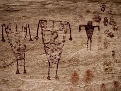
Grand Gulch is an “outdoor museum” and one of the best places in the world to hike for an archeological interest in a scenic and wilderness setting, rather than under a glass case in a museum in some large city. Grand Gulch is full of Anasazi Indian ruins, as well as several earlier archeological sites. Most ruins are around 800 to 1200 years old, but some are as recent as 700 years old, and some are as old as 2000 years old.
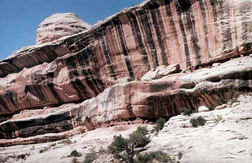
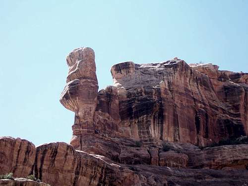
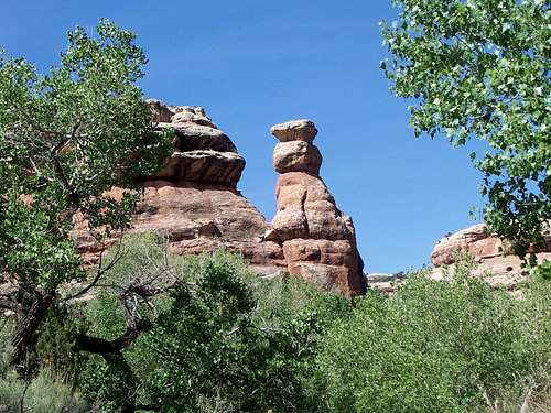 Grand Gulch scenery
Around 1300 AD the Anasazi moved south and into the Rio Grande Valley of New Mexico. Since then, so one has ever lived in Grand Gulch, but the ruins of an ancient civilization remain.
The rediscovery of Grand Gulch happened in 1880, and several archeological parties visited the canyons between the years 1890 and 1897. Now days, it is very illegal to remove or otherwise disturb the sites in any way. Please leave the potsherds, corn cobs, and ruins for other future generations to enjoy.
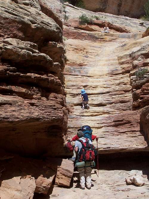
Grand Gulch itself is over 50 miles long, so hikes range from one day to several weeks. There are many opportunities and variations possible.
 Split Level Ruin
Getting There
There are many access points to Grand Gulch. The main trailheads are outlined below:
This area can be reached from the east from Blanding and along Highway 95, from the west and Hite along Highway 95, or from the south via Highway 261 and Mexican Hat, or Highway 47 north from Bluff. Make sure to have a good roadmap before heading into this area. The closest town with gas is Blanding, about 40 miles away from the upper trailheads.
Kane Gulch
Kane Gulch is located four miles south of the Highway 95/Highway 261 junction and is right near mile marker 29. Kane Gulch is also where the ranger station for the Grand Gulch Primitive area is, so just about everyone stops here for information. It is also necessary to stop here for overnight permits for the high season.
Todie Canyon
To drive to the head of Todie Canyon, drive south from the Kane Gulch Ranger station to just north (before) of mile marker 25. Turn west (right) on a gravel road (labeled CR #2361) and follow it for 1.1 miles.
Sheiks Canyon
To reach Sheiks Canyon, drive south along Highway 261 from the Kane Gulch Ranger station to just north of mile marker 25. Turn west (right) here on a gravel road (labeled CR #250) and follow it to a junction, which is reached after 3.1 miles from the highway. Turn right, staying on CR #250 and follow the gravel road to its end. The end of the road is 4.9 miles from the highway.
Bullet Canyon
From the Kane Gulch Ranger Station, drive south along Highway 261 to just south of mile marker 22. Turn west (right) and drive to the trailhead which is reached after 1.1 miles.
Pine Canyon and Step Canyon
This is a trailhead on the west side of Grand Gulch and the access route is different from the above driving routes. Drive along Highway 95 from the east or west to mile marker 87. The access road to Pine Canyon and Step Canyon is about 0.2 miles west of mile marker 87. Turn south, go through a gate, and drive the road for three miles to some slickrock. This location is labeled as 6243T on the topo map.
Pollys Canyon, Government Trail, and Deer Canyon
From the Kane Gulch Ranger Station, drive Highway 261 south to just north of mile marker 19. Turn west (right) along the gravel road (labeled CR #245). At mile 2.6 from the highway (make sure to set trip odometer at the highway), turn right staying on CR #245. At mile 5.6, keep to the right again, and again keep right at mile 7.6. Drive to the end of the road and park. The last section is rough, and if you have a car, you might want to walk it.
Collins Canyon
Like Pine and Step Canyons, this is a trailhead on the west side of Grand Gulch and the access route is different from the above driving routes. Drive along Highway 95 from the east or west to mile marker 83. Turn south on a gravel road (labeled CR #260). Follow the road to its end 6.3 miles from the highway.
San Juan River
If you are a rafter or canoeist, you can hike the bottom of Grand Gulch from the San Juan River. This is a scenic multi-day run from Mexican Hat to Clay Hills, but is beyond the scope of this page.
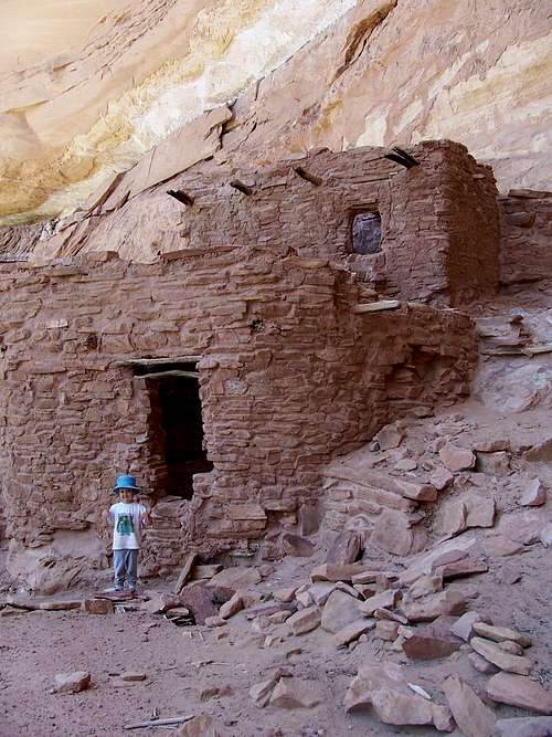
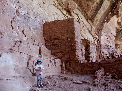
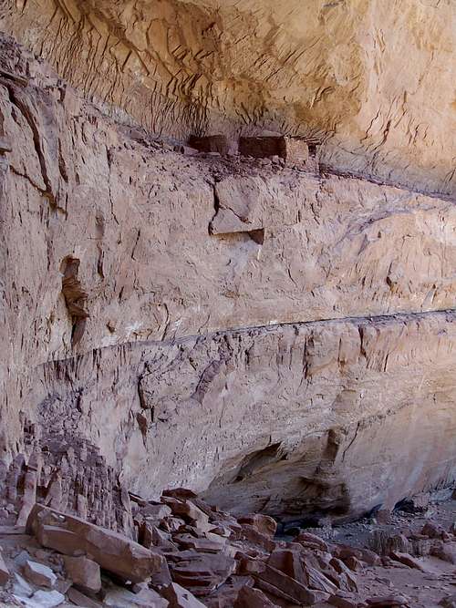 Notice how high on the cliff the ruin is. The ancients must have had some very long and precarious ladders to get up there.
Routes Overview
Kane Gulch
Kane Gulch is by far the most popular entry into Grand Gulch. The route is easy, and class 2, but one ledge can be dicey in winter if it is covered with ice.
There are some nice aspen trees and a few ruins in this canyon before reaching Grand Gulch. The one way distance to Grand Gulch is 3.8 miles.
 Junction Ruin
Todie Canyon
Todie Canyon has many archeological sites, but is a steep and rugged class 3 route. The route is not recommended for winter unless the area is free of snow.
There are many ruins in the canyon, and the lower end has a small but nice little stream, but it doesn’t flow very far. The one way distance to Grand Gulch is 1.4 miles.
Coyote Canyon
Not far north of Sheiks Canyon is Coyote Canyon. A seldom used and rugged route descends into Grand Gulch from this canyon. Unlike Sheiks and Todie Canyons, I don't know of any ruins in this canyon, but it can be used to make a nice, but rugged loop with Sheiks Canyon.
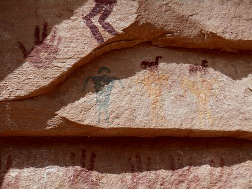
Sheiks Canyon
Sheiks Canyon is another little used steep class 3 route into Grand Gulch. It has ruins in the upper end and pictographs and some water in the lower end. The route is not recommended for winter unless the area is free of snow.
 Pictographs in Sheiks Canyon.
Bullet Canyon
Perhaps the second most popular entry into Grand Gulch is via Bullet Canyon. It’s a long canyon, and long enough that it will have its own SP page (see the link above). The route is 7.5 miles long, class 3, and there are many archeological sites, as well as good campsites and some water. The route isn’t recommended if there is snow or ice around in winter.
 Part of the Bullet Canyon Route.
Pine Canyon
This is a rugged route and sometimes it requires a rope. It is a seldom used route. There is sometimes a wooden ladder fixed at one drop of the canyon. If the ladder is not there, the route requires a rope and rappelling gear.
There are some nice ruins and pictographs in Pine Canyon. Pine Canyon drains into Step Canyon before reaching Grand Gulch.
Step Canyon
Step Canyon is another seldom used route. There are some challenging dryfalls to pass, and several ruins and archaeological sites. About half way to Grand Gulch, Pine Canyon joins Step Canyon.
 Pictographs in Step Canyon.
Pollys Canyon
Pollys Canyon is just north of the Government Trail. It is said to be a moderately challenging route, and has some nice ruins.
Government Trail
The Government Trail is said to be the easiest route into Grand Gulch. It was originally constructed in the 1930’s by the CCC, but vastly improved in the 1970’s. This is the standard route to the famous Big Man Pictograph.
This route along with Collins Canyon is the recommended entry into Grand Gulch in winter, but sometimes the roads can be impassable after a big snowstorm.
 Hiking the Government Trail.
Deer Canyon
Deer Canyon is a rugged and seldom used route into Grand Gulch. It is the canyon to the southwest of the Government Trail. There is at least one route out of the canyon between the two southern forks. You had better talk to the rangers or consult Kelsey’s Canyon Hiking Guide to the Colorado Plateau before attempting the route, as can be hard to find.
Deer Canyon itself has some ruins and pictographs.
Collins Canyon
Collins Canyon is said to be the second easiest route into Grand Gulch. It is an old cattle trail. There are some nice ruins and pictographs in the canyon, as well as an old cowboy camp. In winter, and along with the Government Trail, this is the other route into Grand Gulch that is recommended.
 Grand Gulch near Collins Spring Canyon.
Water Canyon
Several forks of Water Canyon have routes into Grand Gulch, but the routes are very rugged. The northern most fork is said to be easiest.
Shangrila Canyon
This is the first big fork on the east side of Grand Gulch when going up canyon from the San Juan River. The fork between elevation 4945 and 5062 has a route down in.
San Juan River
If you are rafting or canoeing the San Juan River, you can hike up Grand Gulch. The lower end is deep, has a bit of running water, but there doesn’t seem to be any archeological sites.
Mileage Chart
Cumulative Mileage from Kane Gulch Ranger Station:
| LOCATION | MILEAGE | SIDE TRIP |
| Kane Gulch Trailhead | 0 | |
| Junction Spring* | 4.0 | |
| Junction Ruin | 4.0 | 0.2 |
| Turkey Pen Ruin | 4.7 | |
| Stimper Arch | 5.0 | |
| Fortress Canyon | 5.6 | |
| Todie Canyon | 7.2 | |
| Spring | 0.2 | |
| Spring* | 7.5 | |
| Pour Off Pool | 8.8 | |
| Lion Tracks Spring* | 9.6 | |
| Split Level Ruin | 10.0 | |
| Coyote Canyon | 12.8 | |
| Coyote Spring | 0.4 | |
| The Thumb | 13.7 | |
| Shieks Canyon | 14.2 | |
| Green Mask Spring | 0.2 | |
| Bullet Junction Spring* | 15.6 | |
| Jailhouse Spring | 2.2 | |
| Jailhouse Ruin | 2.4 | |
| Perfect Kiva Ruin | 2.7 | |
| Bullet Canyon Trailhead | 7.2 | |
| Totem Pole | 18.0 | |
| Green Canyon Spring | 0.2 | |
| Step Canyon | 19.5 | |
| Step (Necklace) Spring | 0.8 | |
| Dripping Canyon | 22.3 | |
| Dripping Canyon Spring* | 0.8 | |
| Cow Tank Canyon | 22.8 | |
| Cow Tank Spring** | 0.8 | |
| Big Man Panel | 24.7 | |
| Pollys Island | 26.2 | |
| Pollys Spring* | 0.1 | |
| Government Trail | 26.4 | |
| Big Pour Off Spring | 29.3 | |
| Deer Canyon | 31.0 | |
| Deer Canyon Spring | 0.5 | |
| Bannister Ruin | 33.0 | |
| Bannister Spring* | 33.3 | |
| Collins Canyon | 36.0 | |
| Collins Spring Trailhead | 2.0 | |
| The Narrows | 36.3 | |
| Red Man Canyon* | 42.3 | |
| Grand Arch* | 45.0 | |
| San Juan River | 51.7 |
* = Intermittent Spring
** = Hard to access from Grand Gulch
Suggested Routes
There area many routes of all lengths available. Here are just some of the recommended routes. All would make great trips.
One Day:
Hike Kane Gulch to Junction Ruin and back. This route is about 7.8 miles round trip.
Long Day Hikes:
Hike Collins Canyon to Bannister Ruin and back.
Government Trail to Big Man Petroglyph and back.
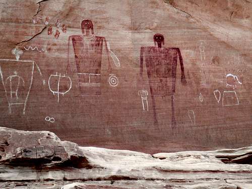 The Big Man Panel in Grand Gulch. The two huge figures, which are about eight feet high are 3000 to 8000 years old. Some of the carved figures are nearer to 1000 years old. This is one of the best pictograph panels in the world.
Hike down Pollys Canyon and exit the Government Trail.
Two Days (or one very long day):
Hike Kane Gulch and exit Todie Canyon.
Hike Todie Canyon, Grand Gulch, and exit Sheiks Canyon.
Hike Sheiks Canyon, Grand Gulch, and exit Bullet Canyon.
Three Days:
Hike down Kane Gulch, down Grand Gulch, and exit Bullet Canyon.
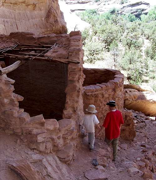 Split Level Ruin.
Hike down Bullet Canyon, Grand Gulch, and exit the Government Trail.
Four Days:
Hike down Kane Gulch, Grand Gulch, and exit the Government Trail.
Hike down Bullet Canyon, down Grand Gulch, and exit Collins Spring.
Hike down Collins Canyon to Grand Gulch, and then Grand Gulch to the San Juan River and back.
Five Days:
Hike down Kane Gulch, Grand Gulch, and exit Collins Spring.
Eight to Ten Days:
Hike Kane Gulch, Grand Gulch to the San Juan River, up the San Juan River, and finally exiting via Slickhorn Canyon. Depending on the route, this is about a 70 mile hike.
Red Tape
Permits are now required for hiking and camping in Grand Gulch. See the official website below for more information:
Cedar Mesa BLM Website
HIGH SEASON – March 1 – June 15 and September 1 – October 31
Day Use Permits
$2.00/per person/per day
$5.00/per person/ 7 consecutive day pass
Permits may be obtained at each trailhead through a self pay system.
Overnight Permits
$8.00/per person/per trip
All advanced and walk in overnight permits must be picked up on the day of your trip at the Kane Gulch Ranger Station between 8:00 a.m. and 12:00 noon, 7 days a week. Advanced overnight permits may be reserved up to 2 days prior to your trip through the Monticello Field Office at (435) 587-1510.
Commercial groups, groups of 8 or more people, or groups using pack or saddle stock must obtain their permits by advance reservation through the Monticello Field Office. Walk in permits will not be issued to these groups.
OFF SEASON – June 16 – August 31 and November 1 – February 28
Day Use Permits
$2.00/per person/per day
$5.00/per person/ 7 consecutive day pass
Overnight Permits
$5.00/per person/per trip
All overnight and day use permits may be self issued at each trailhead during the off season.
Overnight permits for commercial groups, or groups using pack or saddle stock must be obtained in advance through the Monticello Field Office at (435) 587-1510.
ANNUAL DAY USE PASSES
The annual day use pass is $20.00 and can be purchased at the Monticello Field Office or the Kane Gulch Ranger Station. This pass is good through the calendar year and will cover all passengers in the vehicle.
ARCHEOLOGICAL SITES
Disturbing or removing any archeological sites is strictly illegal. Please leave artifacts for others to enjoy.
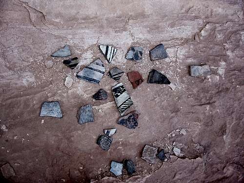 These are some of the pot sherds at Grand Gulch. Please leave them for others to enjoy.
Seasons
Spring:
March through May is the best time to hike Grand Gulch. Water is usually more plentiful than in other seasons, and days are long and pleasant. March and April can be cold and April and May can be hot, but most of the time, this is the prime to go.
Summer:
Summer (June through August) is cooler in the upper canyon, and very hot in the lower sections. Expect hot days and little water. Hiking and camping is still possible, but not as pleasant.
Fall:
Fall (September through November) is another good time to hike Grand Gulch, but the first half of September is usually really hot, and late November can be cold and snowy. Temperatures are similar to Spring, but there isn’t as much daylight. Fall colors usually peak around mid to late October in Grand Gulch.
Winter:
Winter (December through February) can be pleasant if you are prepared. The lower canyon (anywhere from the Government Trail to the San Juan River) is the best place to go in winter, and the upper canyons can be cold, snowy, and icy, and some routes can be dangerous.
 Grand Gulch in May
Weather Forecast and Conditions
Bad weather usually isn't a problem here, and the canyon is wide enough that rain usually poses little danger (this is not true of some other canyons in the area).
CLICK HERE FOR AREA WEATHER FORECAST
Weather and climate data for the Natural Bridges National Monument, elevation 6500 feet, and located near the upper trailheads, is below. *National Weather Service Data 1965-2006. This should be representative of the upper end of Grand Gulch.
| MONTH | AVE HIGH | AVE LOW | REC HIGH | REC LOW | AVE PRECIP (in) |
| JAN | 40 | 19 | 60 | -11 | 1.01 |
| FEB | 45 | 23 | 68 | -13 | 0.83 |
| MAR | 52 | 28 | 77 | 6 | 1.16 |
| APR | 61 | 34 | 85 | 6 | 0.83 |
| MAY | 73 | 43 | 93 | 22 | 0.72 |
| JUN | 84 | 52 | 101 | 30 | 0.46 |
| JUL | 89 | 59 | 103 | 41 | 1.33 |
| AUG | 86 | 57 | 99 | 40 | 1.56 |
| SEP | 77 | 50 | 95 | 22 | 1.33<td< td=""></td<> |
| OCT | 65 | 39 | 86 | 6 | 1.38 |
| NOV | 50 | 28 | 78 | -2 | 1.01 |
| DEC | 41 | 20 | 61 | -14 | 0.91 |
Weather and climate data for the Mexican Hat, elevation 4250 feet, is below. *National Weather Service Data 1948-2006. This should be representative of the lower end of Grand Gulch.
| MONTH | AVE HIGH | AVE LOW | REC HIGH | REC LOW | AVE PRECIP (in) |
| JAN | 45 | 20 | 69 | -17 | 0.59 |
| FEB | 53 | 25 | 78 | -8 | 0.51 |
| MAR | 62 | 31 | 86 | 7 | 0.52 |
| APR | 71 | 39 | 93 | 11 | 0.46 |
| MAY | 82 | 49 | 104 | 27 | 0.47 |
| JUN | 93 | 58 | 109 | 38 | 0.24 |
| JUL | 98 | 66 | 110 | 50 | 0.57 |
| AUG | 95 | 64 | 107 | 46 | 0.62 |
| SEP | 87 | 54 | 103 | 29 | 0.71<td< td=""></td<> |
| OCT | 74 | 41 | 94 | 19 | 0.92 |
| NOV | 58 | 29 | 82 | 8 | 0.59 |
| DEC | 46 | 21 | 68 | -16 | 0.51 |
Camping
There are many campsites throughout the canyon. See the above for camping regulations. See below for the water situation.
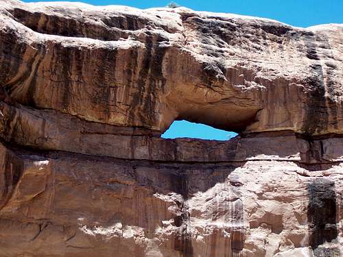 Stimper Arch
Water
Reliable water sources in Grand Gulch above Bullet Canyon are up Todie Canyon and up Sheiks Canyon. Usually there is water at the Grand Gulch/Bullet Canyon junction, and often times at other places scattered throughout the canyon. Other than at the San Juan River, I have not hiked Grand Gulch below Bullet Canyon, but I will post reliable water information after researching it about some more.
Water is the biggest concern while camping in the canyon. In dry times, most of it is stagnant and doesn’t taste great, but is safe after filtration.