
|
|
Canyon |
|---|---|
|
|
Hiking, Bouldering, Scrambling |
|
|
Spring, Summer, Fall, Winter |
|
|
Overview
Natural Bridges National Monument in southeast Utah preserves some of the most impressive natural stone spans in the world. The three main bridges are Sipapu, Kachina, and Owachomo and they span White Canyon and a tributary of Armstrong Canyon. All of the bridges can be seen from viewpoints along the 9-mile scenic one-way paved loop road... but you can't beat the hike to see them up close and personal and stand beneath them!You can hike to all three bridges on a 8.7-mile loop trail. I recommend starting this trail at the Owachomo Bridge parking area, hiking across the pinyon pine and juniper covered mesa first, then descending into White Canyon to Sipapu Bridge. There are steep staircases and ladders that you must descend to get down into the canyon. Once in the canyon the hiking is easy but the trail can be a little difficult to find in spots. Many hikers make a wrong turn near Kachina Bridge and hike down White Canyon and out of the Monument. Watch carefully for trail markers in this area and head up Armstrong Canyon instead.
 Horsecollar Ruin
If you look carefully while hiking in the canyon you can spot many sites where there are Ancestral Puebloan ruins and rock art. Defacing or removing any of these artifacts is illegal. Some ruin sites have a register that you can sign.
A short 1-mile mostly level trail from the road leads to an overlook of Horsecollar Ruin. This is the most famous ruin in the canyon but there are many more! The challenge is to find them... And again, the overlook is okay, but it's more fun to get down in the canyon and see the ruins up close. But please don't touch them and definitely don't climb on them.
 Sipapu Bridge
 Kachina Bridge
 Owachomo Bridge
Sipapu Bridge is the largest of the three bridges at about 270 feet long and the 2nd largest natural bridge in the world (the first is Rainbow Bridge near Lake Powell). In Hopi "Sipapu" is an opening to the spirit world.
Kachina Bridge is the 2nd largest at about 205 feet long and the youngest. It is still being carved out by water thus the hole is relatively small and the bridge is massive. In Hopi "Kachina" is a dancer that is an integral part of their religion.
Owachomo Bridge is the 3rd largest at about 108 feet long and it's the oldest. Its thin delicate span is symmetrical and beautiful. In Hopi "Owachomo" means rock mound and indeed there is a prominent rock mound on the southeast end of the bridge. The hike out of the canyon is shortest and easiest at Owachomo Bridge.
Prospector Cass Hite discovered the bridges in 1883 while he was exploring up White Canyon from the Colorado River. Natural Bridges was the first National Park area to be designated in Utah. It was designated in 1908 by President Theodore Roosevelt.
Getting There
The entrance to this remote National Monument is at the end of Highway 275, which is roughly 35 miles west of Blanding, UT on Highway 95. Driving time from Blanding is roughly 45 minutes. No services are available in the monument and cell phone coverage is poor to non-existent. The nearest reliable food, gas, and other services are in Blanding. But many shops are closed in Blanding on Sundays and the selection is limited. The hamlet of Mexican Hat is 44 miles to the south and has very limited services. 20 miles to the west is Fry Canyon which last I was there had a pay phone and a restaurant but with very limited hours. 95 miles west is the small town of Hanksville which has gas, a couple of small hotels, and a couple of small stores and restaurants. Hite Marina, 50 miles west of the monument, offers gas, a pay phone and a convenience store. 2 hours to the northeast is the larger town of Moab which has a much wider-range of services than these other small communities.Click here for maps of this area
Red Tape
Park Entrance Fees of $6 per car or $3 per person are charged. You can also buy an annual pass for Natural Bridges, Arches, and Canyonlands for $15. Or you can buy an $80 America the Beautiful Federal Lands Recreation Pass good for entrance to all National Parks, National Forests, BLM, US Fish & Wildlife, and Bureau of Reclamation sites for one year from date of purchase. If you're disabled, you may want to get an Access Pass which are free and good for a lifetime. If you're 62 years of age or older, a Senior Pass can be purchased for $10 and they're also good for a lifetime. Click here for more info on fees and passes.Pets are not allowed on trails but are allowed in the campground and on paved roads on a leash.
Bicycles are allowed on the paved road but not on trails.
No overnight backpacking is allowed in the monument but dayhiking is allowed and is popular.
Climbing on and walking on top of the bridges is not allowed. Technical rock climbing is not allowed due to the weak crumbling nature of the sandstone but scrambling is allowed.
There isn't always water in the canyon and when it's there it should be left for the native plants and animals that depend upon it so plan on bringing all the water that you'll need while dayhiking here.
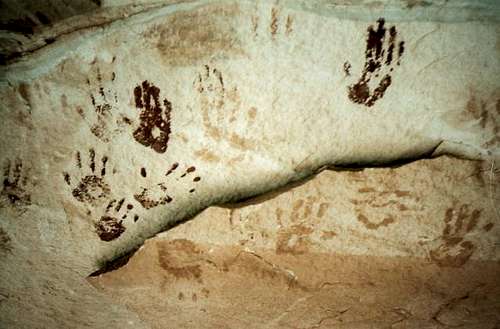 Hand Print Pictographs
Camping
There is a small 13-site campground at Natural Bridges National Monument that is first come-first served and open year-round. The cost is $10 per night. Gathering firewood is prohibited. Water is not available at the campground but it is at the visitor center. Campfire programs may be offered in the summer season.You can also disperse camp on surrounding BLM lands, inquire at the visitor center for more info.
External Links
Natural Bridges National Monument WebsiteCanyonlands Natural History Association
National Weather Service Local Weather and Forecasts
For More Info
Natural BridgesHC-60 Box 1
Lake Powell, Utah 84533
(435) 692-1234
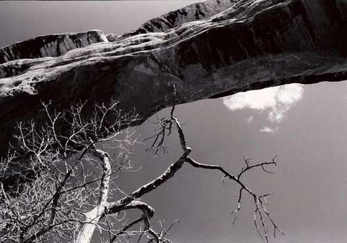 Sipapu Bridge from below
Etc.
Don't bust the crust!When hiking off trail please stick to durable surfaces such rocks and sandy washes. Most of the land out here is covered with a cryptobiotic soil crust. This is a living layer of mosses, fungi, and bacteria that help hold the soil in place, prevent erosion, retain moisture, and provide vital nutrients to neighboring plants. Without the crust many other plants wouldn't be able to grow and one footprint can break down years of this living crust so stay on trails whenever possible!
More info on cryptobiotic crust
How do natural bridges form?
A very good written explanation and diagrams are available in this NPS publication.
Nearby Areas to Explore!
More of White Canyon including the infamous Black Hole
Grand Gulch
Bullet Canyon
Comb Ridge
Moki Dugway
Goosenecks State Park
Mexican Hat
Monument Valley
Hovenweep
The Bear's Ears
Dark Canyon
Abajo Mountains
Glen Canyon/Lake Powell
Canyonlands National Park, Needles District
Scott - Sep 1, 2006 2:52 am - Voted 10/10
RuinsBest Ruins in the canyon are actually up canyon from Sipapu. These rank as some of the best ruins anywhere on the Colorado Plateau. Look around lower Burch and near the White/Burch Confluence.