
|
|
Canyon |
|---|---|
|
|
36.50706°N / 51.75955°E |
|
|
Canyoneering |
|
|
Summer |
|
|
Overview
Click for Introduction to the Central Alborz Mountains.Click for a Detailed Map of the Central Alborz Mountains.
Alborz Mountains
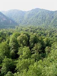
The Alborz Mountains rise very abruptly above the southern coast of the Caspian Sea trapping the moist air generated by the sea. Unlike the bare southern slopes, the northern slopes of the Alborz Mountains are covered by a lush growth of deciduous forest. On their mad rush to reach the sea, countless streams and rivers have dug canyon of various proportions into the northern slopes of the Alborz Mountains.
Kojoor Plateau & Kojoor Canyon
 Kojoor Plateau
Kojoor Plateau is a small plain that sits at an elevation of 1500 m among the peaks of the Alborz Mountains roughly 22 Km south of the Caspian Sea Coast. Although the mountains that surround the Kojoor plateau are forested, the plateau itself remains tree-less.
Kojoor Creek originates in the mountains south of the Kojoor Plateau and heads north. After crossing the plateau, it enters a canyon at the base of the 2626 m Ghal-eh Gardan Peak to the west and the 2327 m Valik Bon Peak to the east. It then continues north, cutting a deep canyon among the other peaks of the area until it drains into the Caspian Sea.
A Near Perfect Wilderness
Although local herdsmen do at times take their cattle into portions of the Kojoor Canyon, you will not find any permanent settlements in or near the canyon. This has caused the canyon to retain much of its wild character.
Warning to Hikers
Flash Floods can happen at any time in the Kojoor Canyon. Hikers have actually died as a result of these floods. The floods do create debris fields that are often quite tedious to traverse.
In the upper portions of the canyon the stream is quite small and will allow you to easily cross from one side of it to the other. In the lower canyon, the volume of the water does increase making the crossing more difficult (but usually possible). Be ready to get wet and to negotiate the many obstacles that the canyon throws at you.
Also be ware of the inviting trails that leave the canyon and head up the forested slopes. While some of these trails do make the hike much easier, others fade away in the forest. It is quite easy to get disoriented and become lost in the dense forest.
Major Obstacle
After a day and a half of hiking we reached a waterfall. The waterfall is a dead end for the hiker (it can obviously be passed by those who have proper training and equipment). It took us 6 hours to find a way around the waterfall (We ended up roping ourselves down a wall on the side of the canyon, see more details below).
Hiking Distance and Hiking Time
Unfortunately, low GPS signal in large portions of the canyon prevented me from obtaining an accurate hiking distance. On a straight line, the distance between the starting point (see below) and the Caspian Sea Coast is only 18 Km. I have read reports that claim a hiking time of as little as 16 hours. These reports do not give much detail and make no mention of the major obstacle mentioned above. It is possible that there might be trails in the forested slopes far above the canyon that can be followed. Except for 3 short segments of trail, we did not encounter any other viable trails. Hiking on the banks of the stream is extremely slow. Mistakenly following trails that fade away in the forest, will obviously waste much time. We made the hike in two and a half days (including the 6 hours we spent trying to find a way around the major obstacle noted above).
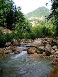
The Canyon
The Start of the HikeGPS Coordinates:
36:25.936 North
51:44.195 East
Elevation: 1390 m
We started our hike at a point on the road with the above coordinates (see “Getting There” at the bottom of the page).
 Looking North Looking North |  Looking South Looking South |
Mountain Slopes Around the Beginnings of the Canyon
Many mountain slopes in this area are rocky/wall-like.
 |  |  |
 |  |  |
Entering the Forest
After a short hike, you will enter the forest.
 Upper Forest
 |  |  |  |
Flowers in the Upper Canyon
 |  |  |
 |  |  |
Canyon Begins to Form
As you continue north, a canyon begins to form
 |  |  |
Stream Junction
GPS Coordinates
36:27.093 North
51:44.035 East
Elevation: 1250 m
At the above location, a major contributory stream knows as “Been Creek” joins the Kojoor Creek from the west.
Continuing Down the Canyon
 |  |  |  |
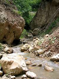
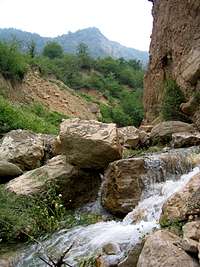
Small Waterfalls
You will come across small waterfalls such as the ones shown in these pictures. You can find your way around the falls with minimal effort. The coordinates for the falls shown in the large picture are as follows:
GPS Coordinates
36:27.286 North
51:44.165 East
Elevation: 1205 m
 |  |  |
Continuing Down the Canyon
 |  |  |
Open Canyon
 |  |  |  |
Narrows
GPS Coordinates:
36:28.321 North
51:44.68o East
Elevation: 1065 m
Here the canyon becomes quite narrow. The stream becomes wide and very shallow. You will have to hike right over the running water. Flash flooding can turn this area into a death trap.
 |  |  |
 |  |  |
Wide Open Area
A wide valley forms.
 |  |  |
Black Canyon
You will enter a canyon with tall black rocky walls.
 |  |  |
Denser Forest
The forest seems to become very lush.
 |  |  |
Trail in the Forest
GPS Coordinates:
36:29.558 North
51:44.430 East
Elevation: 930 m
Here you will find a trail on the west side of the creek. Following it, can make the hike much easier. The trail goes 100 vertical meters up slopes that are covered by meadows to reach a high point and then it enters a forest.
 |  |  |
Trail in the Forest
After the high point mentioned above, the trail enters a beautiful forest and begins to descend.
 |  |  |
Back to the Creek
GPS Coordinates:
36:30.040 North
51:45.127 East
Elevation: 760 m
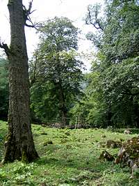
After a short distance in the forest, the trail returns to the creek and continues north a little longer to reach a flat grassy area among the trees. Some sort of a structure probably built by local herdsmen can be seen there. The trail then simply vanishes away.
 Structure in Meadow
The Big Orange Wall
This impressive wall comes to view on the west side of the valley. You can see faint trails that go up to reach the base of the wall but the wall does not allow you to hike in that area any further.

 |  |  From Base of Wall From Base of Wall |
 |  |  |
Bushwhacking in the Canyon
You will most likely be forced to return to the canyon and bushwhack your way along the creek.
 |  |  |
 |  |  |
The Great Waterfall
GPS Coordinates:
36:30.424 North
51:45.573 East
Elevation: 700 m
A spectacular waterfall suddenly appears on the west side of the Canyon.
 |  |
Continuing Down the Canyon
 |  |  |
The Big Gray Wall
GPS Coordinates:
36:30.646 North
51:45.838 East
Elevation: 645 m
At the above location, you will find a trail on the east side of the canyon. The trail goes up meadows where you will have awesome views of the great gray wall to the west.
 |  |  |
Trail in the Forest
The trail then goes downhill in the forest.
 |  |  |
Back to the Creek
GPS Coordinates:
36:31.082 North
51:46.200 East
Elevation: 520 m

Major Obstacle
Very shortly after returning to the creek you will come across these waterfalls. In this picture you can only see the beginnings of the falls (you will have to go over very steep slick rock to even see the big waterfall). The falls have vertical slick rock on both sides. For the hiker this area is a dead end (obviously with proper equipment and training you can pass these falls). We spent 6 hours trying to find a route around the falls. The slopes on the east side of the falls were covered by a truly impenetrable growth of thorny bushes under the trees. The forested slopes on the west side of the falls were steep and muddy. These slopes turned into a jumble of overhanging roots before they dropped vertically down several tens of meters to the bottom of the canyon. We were finally able to find a spot where we could rope ourselves down the near vertical slopes back to the creek.

The Last Walls
As you go north, you will note that the mountains are becoming gentle. You are probably looking at “the last walls”.
 |  |  |  |
More Bushwhacking
Bushwhacking, however, might have become more intense.
 |  |  |  |
Trail on the West Side
GPS Coordinates:
36:31.960 North
51:46.857 East
Elevation: 350 m
Here a trail takes you up the western slopes into the forest. At the above coordinates, a log bridge takes you to the east side of the canyon.

Frustrating Bushwhacking
After you cross to the east side, make sure you go up the slopes on the east side. If you attempt to follow the creek, you will see nothing but extremely frustrating bushwhacking, not worth a fight.
 Bushwhacking, if you miss the trail
Trail in the Meadows & Forest
After crossing the log bridge to the east side, go up the slopes to reach a meadow. You might find a cattle holding area here. The trail follows up the meadows and enters a forest on the edge of the upper slopes of the canyon (Do not follow another trail that keeps going up the forested slopes away from the canyon). The trail then goes down the forested slopes to return to the creek.
 |  |  |
Back to the Canyon Floor & Side Waterfall
Once you reach the canyon floor, you will find it much wider. This beautiful waterfall will be seen on the east side.
 Waterfall Waterfall |  Canyon Floor Canyon Floor |
Fighting Lizards
At first, these lizards did not even seem to notice that we were standing right above them. I think the aggressor finally noted us and let go of the victim allowing them to both run away.

End of the Canyon
The canyon floor turns into a wide bed of medium size rock. A dirt road and small water management facilities appear. You will notice that the creek seems to have vanished away. It is probably diverted away.
 |  |  |  |
Caspian Coastal Plain
You are suddenly out of the mountains and on the coastal plain. Elevation is around 100 m. a 3 Km hike on a road that goes among the private properties takes you to the Coastal Highway.
 |  |
Caspian Sea
Go under the overpass and you will reach the Caspian Sea (Said to be 25 meters below Sea level but my GPS said minus 10 meters). You are somewhere near “Sisangan National Forest” roughly 40 Km east of the coastal town of Chalus. Unlike the beautiful sandy beaches in other parts of the Caspian Coast, the beach here is covered by medium size rock. Walking barefoot on the hot rocks after several days of hiking is not a pleasant experience but at least you can get in the water and wash the mud and grime away.
 |  |
Getting There
From the western portions of Tehran, drive to the town of Karaj and then take the Chalus Rd north. Around 7 Km north of the village of Marzan Abad, at a place called “Do-Ab”, turn east and follow the road to reach the village of Kojoor. Approximate distance from western Tehran to Kojoor Village is 240 Km (another option is to drive the Haraz Rd and take the side road to the village of Baladeh. From Baladeh, you will drive the road toward Royan. Before reaching Royan, at a place called Galand Rood, you will turn west onto a road that goes up to a high point and then descends into the beginnings of the Kojoor Canyon before reaching the village of Kojoor).I the village of Kojoor, follow the road east. The road will soon turn northward and follows the Kojoor creek on the east side of it (this road will eventually leave the Kojoor Creek and head back east to descend into the Galand Rood River Valley). After a short distance, you will see a nameless side road on the left (west). Turn onto this road and cross the Kojoor Creek. You are now right along the Kojoor Creek. You can start your hike anywhere (this road will probably eventually go to the village of “Been”)