
|
|
Mountain/Rock |
|---|---|
|
|
36.05921°N / 111.8428°W |
|
|
Hiking, Scrambling |
|
|
Spring, Summer, Fall, Winter |
|
|
6281 ft / 1914 m |
|
|
Overview
The two can be linked up with a pretty straight forward traverse, with a small butte in between, affectionately known as Escaldenas Butte.
What makes the traverse so special is that Escalante is just high enough to break into the layer of white boulders of Coconino Sandstone as the summit, while Cardenas's lower summit is red blocks of Supai sandstone, making the two adjacent summits very different.
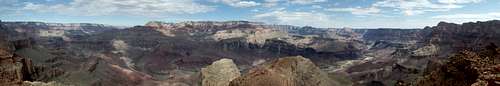
Cardenas Panorama
Getting There
Route
Trip Statistics are for an Escalante- Cardenas traverse, YMMV.
Mileage: 9.2 miles roundtrip
Mileage: 9.2 miles roundtrip
Elevation Gain: 3200' (nearly 2000' of it on the return)
Crux: class III
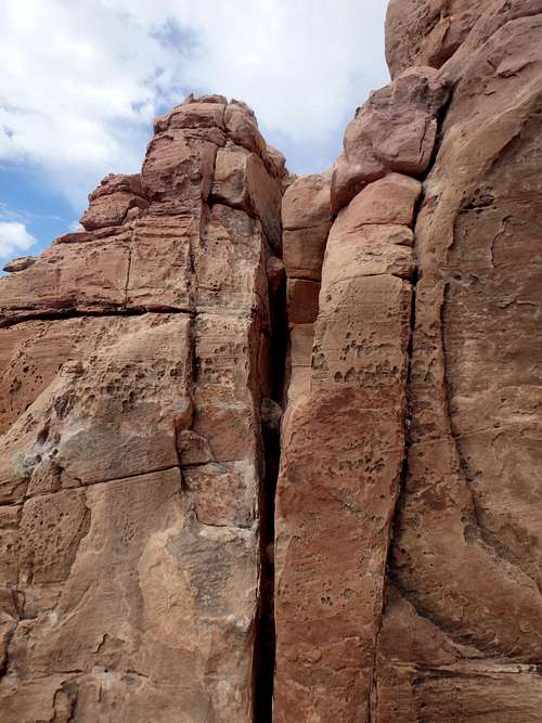
Cardenas Crux
If you're traversing to or from Escalante, the middle to upper ridge between Cardenas and Escaldenas has a handful of ledges to work through, and will require you to drop off the ridge to the south a couple of times to get around them.
Red Tape
Admission to GCNP is $30 for 7 days. I highly recommend the "America the Beautiful" Pass for $80, which covers the entrance fees for all federally managed parks and land for one year.
No additional permits are needed unless you're planning on incorporating this into a backcountry trip.
When to Climb
Camping
There are two developed campgrounds on the South Rim: Mather (which takes reservations) and Desert View.
Per the NPS on backcountry camping off the Tanner Trail: As part of the ongoing efforts to salvage plant and animal habitats that revolve around what remains of the old pre-dam sediments near the river, the large sand dune at the mouth of Tanner Canyon is closed to visitation. With this exception, the Tanner Canyon Use Area (BB9) allows "at-large" camping. There are nice (although dry) established campsites at the Seventyfive Mile Creek - Tanner Canyon saddle, trailside in the Supai, above and below the Redwall, and in the Tapeats. Campsites near the river can be found on the east side of Tanner Canyon. A composting toilet is located nearby.
The only water source is the Colorado River.
There is plenty of places for camping at large in the National Forest just outside the park.