
-
 12090 Hits
-
 77.48% Score
-
 8 Votes
|
|
Route |
|---|---|
|
|
31.69260°N / 110.8677°W |
|
|
Hiking |
|
|
Spring, Summer, Fall |
|
|
Most of a day |
|
|
Class 1 with a short 1+ social scrub-whack |
|
|
Overview
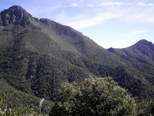 Mount Wrighton and Josephine Peak
This loop route blends the opportunity for greater solitude on one leg with a speedy descent along the other. Starting on the Carrie Nation Mine Trail, which sees much less traffic that the nearby Old Baldy Trail, the hiker can enjoy peace and quiet along the creek bed and admire old mining ruins. Above the Carrie Nation Mine, some easy route-finding above the mine on social trails enhances the feeling of solitude. The route then traverses along the Aqua Caliente trail to reach a spur trail ascending the northern ridge of Jack Mountain. After a stop at the summit, the social trail carries the hiker back to the Aqua Caliente Trail to the crowds at Josephine Saddle, to descend to the parking lot via the popular Old Baldy Trail
• Roundtrip Distance: 5 miles
• Elevation Gain: 1,900 feet
• YDS Class: 1+
 Jack Mountain Summit Register
Getting There
The entire drive is on pavement and suitable for all passenger vehicles. Extremely large vehicles (e.g. RVs) will not have a good time on the narrower portions of twisting road higher in the canyon. From the center of Tucson to this trailhead takes about 1 hour and 15 minutes of driving.• Follow I-19 to Green Valley, Arizona
• Exit #63 Continental Road.
o From the exit, it is a good 12 miles to the trailhead
o Follow signs to Madera Canyon Recreation Area, they are plentiful
• Take the road to the east (if coming from northbound I-19, you will pass under the interstate)
• Keep an eye out for the plentiful signs to Madera Canyon! You will leave the desert floor and enter the wooded canyon, heading toward the Santa Rita peaks.
• Follow the road to its very end, high up in Madera Canyon, where there are two lots, and upper and lower lot for parking.
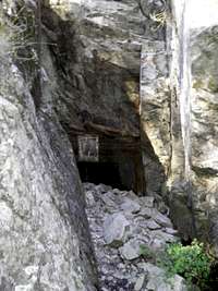 Old mining drift Old mining drift |  Cairn marking start of summit path Cairn marking start of summit path |  Mining Boiler Mining Boiler |
Route Description

• From the paved parking area, follow signs to the Old Baldy Trail. The route begins on an old dirt road to the southwest of the parking lot.
• After a brief climb, reach a junction. Follow the signs for the Carrie Nation Mine Trail, roughly straight ahead (the Old Baldy Trail here turns sharply uphill to the left).
• Follow the Carrie Nation Mine Trail up a beautiful creek bed for less than 1 ½ miles to the Carrie Nation Mine ruins.
• A sign near the mine suggest the trail ends here, and the officially maintained trail does indeed end.
• Shoot south up the ridge behind the mine, departing a drainage. The social trail here will be faint yet easy to follow to the keen-eyed.
o Note: It is worth the effort to stay on the trail to easy passage up the steep slope and avoid thrashing through underbrush and trees. If faced with multiple social trails, continue upward and do not get pulled into the drainage which will be on your left.
• The social trail continues to just below the southwest ridgeline of Jack Mountain where it intersects the Aqua Caliente Trail.
• Turn east (left) on the Aqua Caliente Trail and follow this for roughly ¼ mile to the north ridge of Jack Mountain. Here the trail makes an obvious loop out onto the ridge.
• Look to your south/right for a small cairn. This marks the start of the social trail to the summit of Jack Mountain.
• Hop on this faint but helpful social trail as it goes through the trees then into the scrub and grass on the top of the peak. The summit of Jack Mountain is marked by a simple cairn and a summit register. The views to the east and the west are sublime.
• Descend the social trail northward to re-intersect with the Aqua Caliente trail.
• Head east (right) on the Aqua Caliente trail as it traverses the slopes for roughly ¾ mile to the Josephine Saddle. From here, follow the popular Old Baldy Trail all the way down to the picnic area.
Essential Gear
 October Sycamore
 Sycamore bark close-up
• Standard hiking equipment suitable to the season
• Plenty of water (the spring shown on the map is awfully close to the Carrie Nation Mine for drinking purposes)
• Map: Green Trails No 2962S Santa Rita Mountains