
|
|
Mountain/Rock |
|---|---|
|
|
38.82840°N / 105.98025°W |
|
|
chaffee |
|
|
Mountaineering |
|
|
9792 ft / 2985 m |
|
|
Overview

The North Face of Castle Rock
North Face

NE Face
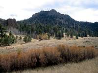
Castle Rock sits among the low mountains that rise on the east side of the Arkansas River Valley near the town of Buena Vista in Central Colorado. Castle Rock is not connected to any of its nearby mountains. It rises very abruptly above a small plain that has an elevation of 9000 ft. Sheer walls and steep rocky slopes give Castle Rock a very rugged appearance. If it were larger in scale, Castle Rock would have surely been a famous mountain.
The most logical way to reach the summit of Castle Rock is via a slope on the north face of the mountain that goes up to just below the summit without reaching any walls. This slope is very steep and climbing it requires some degree of bushwhacking. An approach from the south via a scree and thorn filled gully has also been described (see “External Links” at the bottom of the page).

The Northwestern Face of Castle Rock
Getting There
From the town of Buena Vista, drive 2 miles south on Route 24 to reach the intersection with Route 24/285. Turn east and drive Route 24/285 through Johnson Village and continue 6.3 miles until you see the sign for Forest Road 307 on the right (south side). Turn onto Road 307 and drive 1.6 miles until you reach Forest Road 187. Turn right (east) onto Road 187 and drive less than a mile until you see Road 300 (Bald Mountain Gulch). This is a good spot to park your car (Forest Roads 307 and 187 are well-graded dirt roads that are passable by most/any car). NW Face |  NW Face |  NW Face |
Route (North Face)
Trailhead Elevetion:8920 ftOne Way hiking Distance: Less than a mile
Identify the slope on the north face of Castle Rock that does not have any walls.

North Slope
From the parking area, cross Forest Road 187 and head toward Castle Rock. You will have to cross Castle Rock Creek. You will find dense growths of bushes in some areas.
 Creek |  Creek |
Hike up the lower slopes of Castle Rock. The forest is fairly thin but in some places bushwhacking is required.
 Lower Slopes |  Lower Slopes |  Lower Slopes |  Lower Slopes |
As you go higher, the slope becomes steeper. You will note that the slope that you are on goes between two big rocky walls.
 Walls |  Walls |  Walls |
It then becomes even steeper and you might have to deal with scree.
 Steep Slopes |  Steep Slopes |  Steep Slopes |  Steep Slopes |
Just below the summit, you will find this little gully. Go up the gully and reach the summit.

Gully
Views from the summit:
 NW/Yale & Harvard |  W/Princeton & Antero |  South |  E/SE |
 E/Kaufman Ridge |  N/Buffalo | 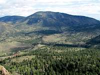 NE/Kaufman North |  "The Casles" |
The South Face of Castle Rock

The South Face of Castle Rock
From the southeast, Castle Rock looks like a long wall. You could potentially go up a gully directly below the summit to reach the top. This gully is probably full of loose rock and thorny bushes. (see “External Links” below).
 South Face |  Gully on the south Face |