
-
 24928 Hits
-
 81.49% Score
-
 14 Votes
|
|
Mountain/Rock |
|---|---|
|
|
49.66300°N / 125.387°W |
|
|
Hiking, Skiing |
|
|
Spring, Summer, Fall, Winter |
|
|
5709 ft / 1740 m |
|
|
Overview
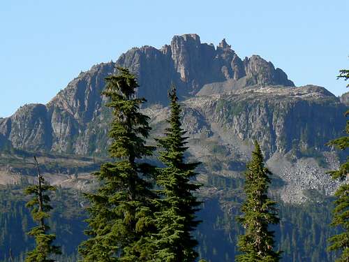 Castlecrag Mountain Castlecrag Mountain |
The mountain's appeal lies in its dramatic, craggy aspect when approached from the north and in the fact that it forms part of a spectacular high circular route taking in 3 summits and their connecting ridges.
The summit is a worthy destination in its own right, offering wonderful views straight down to Moat Lake, NW across to the higher summits of Mts Albert Edward and Frink and south down the chain of peaks as far as the Comox Glacier. It is also far less frequented than the popular return hike to Mt Albert Edward from Circlet or Kwai Lakes.
Like most mountains in the immediate area, Castlecrag can be climbed in winter and spring on snowshoes or skis. It can also be tackled in a long day from cars without the need to camp. The round trip distance is approximately 30km with a 750m elevation difference.
Getting There
Vancouver Island can be reached by air from Vancouver to Victoria, Nanaimo or Campbell River and by ferry from Port Angeles to Victoria on The Coho and on BC Ferries from Vancouver to Victoria or Nanaimo. Public transport on the Island is relatively poor and anyone arriving by air would be advised to rent a car. Access in this case is all on paved roads and, therefore, fine with a normal sedan. Approach from north or south in the Inland Highway 19. Near Courtenay take the Strathcona Parkway exit west to Mount Washington Alpine Resort (the reason for the paved road to 1000m). Drive up 20km and just before reaching the resort make a left turn onto Henry Road, following Parks signs for Paradise Meadows. Pass the bottom of the ski lifts after 1.5km and drive a further 0.5km to the end of the paved road at the cross-country facility Raven Lodge.Parks have established a new trailhead and information booth right beside the lodge. If you get back from your trip before 5.30 pm, the Raven Lodge has a lovely view over to the mountains and is a great place for the beer you so rightfully deserve!
Approach/Route
Complete the formalities (see below) and head out across the boardwalk onto Paradise Meadows. The approach to Castlecrag can be made as part of a circular route enabling infrequent visitors to see as much of the park as possible. Reference to this map illustrates the possible choices. I recommend going out via Battleship, Croteau and Kwai Lakes and returning on the somewhat shorter route via Hairtrigger and Helen Mackenzie Lakes. This also offers the option to camp at Kwai Lake if this is as far as you want to carry a heavy pack without backtracking from Whiskey Meadows. If you are planning a day trip, whether just to Castlecrag or on the complete high level circuit, going out and back via Lake Helen Mackenzie will save at least an hour if time is a critical issue. Either choice brings you in 2-4 hours, depending on your pack weight and the photo opportunities en route, to a marked trail junction for the campground at Circlet Lake. If you are staying here the night, turn right and along the shore of the small unnamed lake before dropping down slightly into the bowl that holds Circlet. If you are undertaking a day trip, head straight on across the head of the small lake and up the trail towards Mt Albert Edward. Average time to Castlecrag summit from this point with a light pack is about 2.5 hours.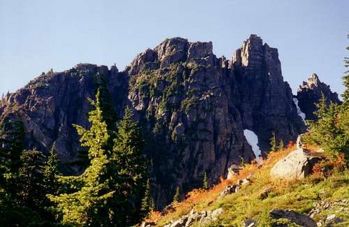 Castlecrag Mountain summit | 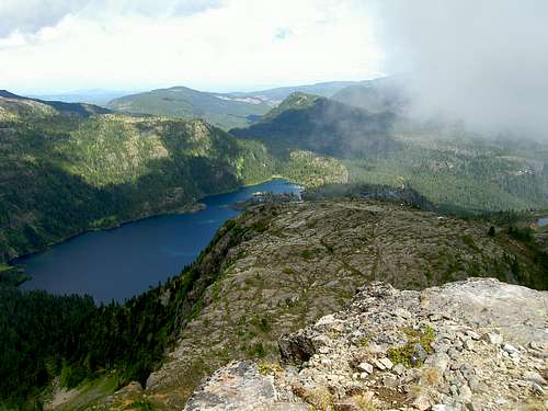 Moat Lake from the summit | 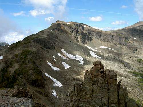 Mt Frink from Castlecrag |
The trail makes a beeline for a low point on Castlecrag’s east ridge crossing a large boulder field just prior to reaching there. As soon as you arrive on the east ridge look for flagging and a sharp right turn. A well-worn path flatters to deceive by leading straight on across to the south side of the ridge but soon peters out into bush. Having taken the correct right turn you are now heading west on the opposite side of the summit block to that you approached on. Climb up towards the summit until you reach a well-marked junction. Straight on for the circular route and Mt Frink, which now lies directly in front of you to the west, and right (NE) up to Castlecrag. The summit is a 15-minute scramble from here. There is a summit register to read and sign while you’re enjoying the wonderful views.
Reverse the spur route down to the main trail and then carry on over Mt Frink and Albert Edward or simply retrace the above back to camp or your car.
Red Tape
If you are a day-tripper, there is nothing to pay. If camping at Kwai or Circlet Lakes, or anywhere else in the designated core area of Strathcona Park, there is a $10/person/day fee. There is a self-registration box and payment slot at every core designated trailhead. Payment can be by cash or cheque. I haven’t seen a stipulation specifying Canadian funds but I’m sure Parks wouldn’t refuse a cheque in US funds.Camping
In this and all core areas of Strathcona Park you must camp only in the designated areas. In the present example this means at Kwai or Circlet Lakes. At each you will find a dozen or so wooden platforms. If none are available choose a site on the dirt that will cause as little impact as possible. Fires are strictly prohibited, so you must pack a stove. Both camping areas have a pit toilet and bear proof food cache. Giardia is well documented throughout Strathcona Park, so boil or treat all water.Links/Suggested Reading
Strathcona Provincial ParkAdditional Information/Suggested Reading:
Beyond Nootka – A Historical Perspective of Vancouver Island Mountains, Lindsay Elms, Misthorn Press, 1996, ISBN 0-919537-29-4
Island Alpine – A Guide to The Mountains of Strathcona Park and Vancouver Island, Philip Stone, Wild Isle Publications, 2003, ISBN 0-9680766-5-3
Weather
Nearest point current conditions and forecast:AND/OR
You can get a live view of what the weather's doing right now at the Paradise Meadows trail head from Mt Washington's webcam