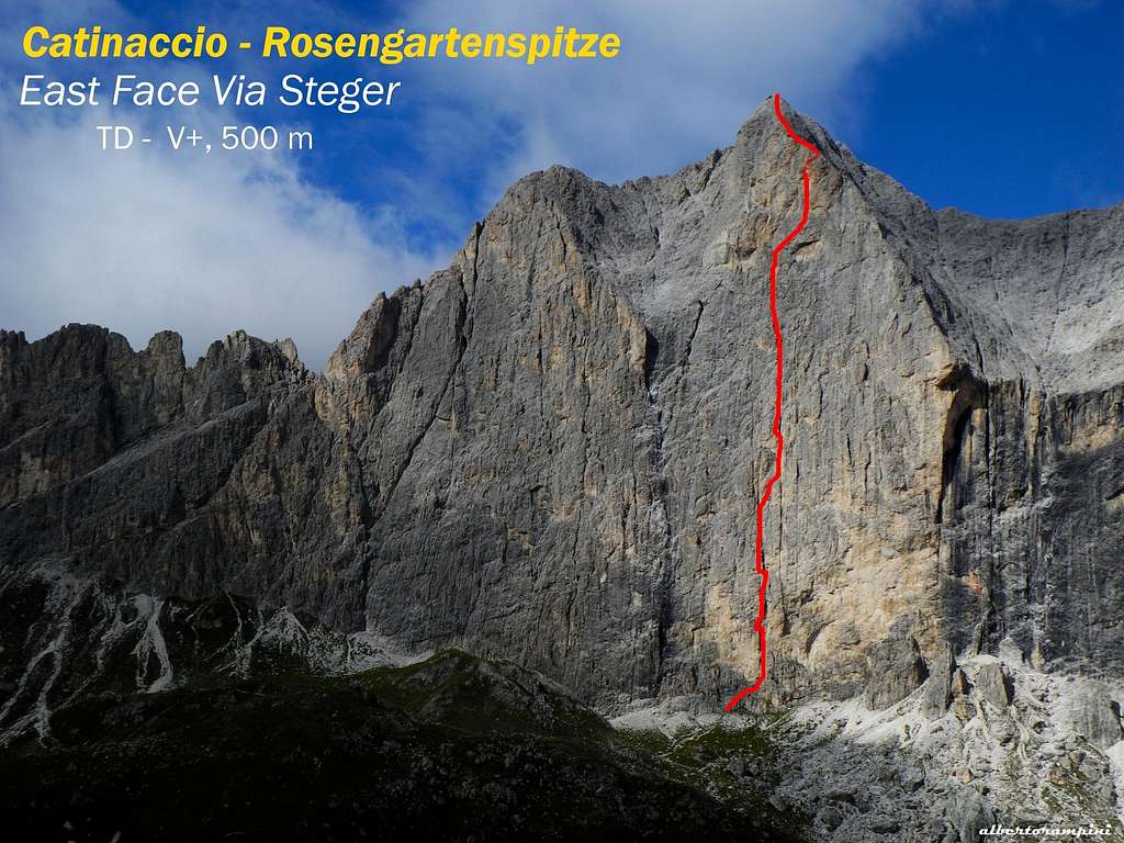
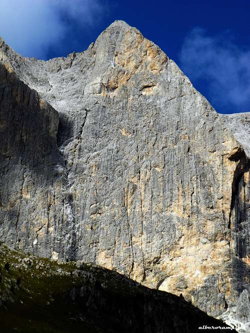
Catinaccio East face, a magnificent sunny wall overlooking the peaceful meadows of Gardeccia! Amongst the countless climbing routes running on this impressive wall the most logical line and fulfilling climb is the Diretta Steger (Steger Direct), an ideal line and one of the greatest classic routes not only in the Catinaccio group but in the whole Dolomites.
Catinaccio from Dirupi di Larsèc
The route doesn’t oppose extreme difficulties, but however the climbing is sustained, especially in the low section, where the wall is steep and impressive. Substantially the route remains still challenging in reason of its length and the flair needed to find the correct itinerary. In fact there are many variations, but the best advice is to follow the original route realized by the formidable pair of climbers Hans Steger and his wife Paula Wiesenger with F. Masè Dari and S. Lechner in the year 1929. An excellent and very satisfactory way to climb the majestic East wall and get directly to the second highest summit - after Catinaccio d'Antermoia - of the Catinaccio Group. The belays anchors are almost all on site, as well as a few pegs along the pitches.
Catinaccio - Photo Vid Pogachnik
Catinaccio East wall seen from Campanile Gardeccia
History
Hans Steger
Paula Wiesinger (1907-2001)
Hans Steger and Paula Wiesinger were a formidable pair of climbers and skiers. Hans was born in Bavaria in 1907 and met Paula in her hometown, Bolzano. They were both twenty years and not separated anymore. Together they lived extraordinary mountain adventures, realizing some challenging routes in the Dolomites, such as "Via della Giovinezza" on Cima Una in the Sesto Dolomites in 1928 only twenty-one and the following year the East of Catinaccio and the South of Torre Winkler, always in the Catinaccio group. Among their greatest repetitions stand out some routes of high commitment as Micheluzzi on the South face of Marmolada and Solleder on the North-West face of Civetta. After this latter climb Paula was consecrated the first woman of the Sixth Grade Age in the history of mountaineering.
Getting There
Flowery chalet along Gardeccia approach
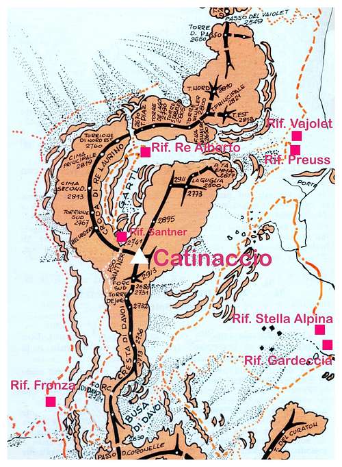
The starting points to climb Steger Route is the resort of Pera di Fassa, located in the homonymous Val di Fassa
Road access to Pera di Fassa and Gardeccia
- coming from Brennero Motorway exit Egna-Ora and take the road S51 towards Val di Fassa, getting to Cavalese, Predazzo, Moena and Pera di Fassa (48 km. from Egna-Ora). The road from Pera di Fassa to Gardeccia is open to private vehicles as far as the little hamlet of Soial. Currently (summer 2020) the shuttle bus service departing from Pera di Fassa is no longer available. In Pera di Fassa there is a chair-lift that will lead you to the upper station (rif. Ciampedie), from here 30 minutes by walk to reach Gardeccia. Alternatively there is a cable car in Vigo di Fassa leading to the same destination.
Route Description
Steger Direct original route report - UIAA SCALE
Summit altitude: m. 2981 Difficulty: TD inf., UIAA V+ Climbing length: 500 m. + 150 m. on the summit ridge Equipment: the pegs at belays are on site, as well as some pegs along the pitches, needed quick protections to integrate Exposure: East First ascent: Hans Steger - Paula Wiesenger - F. Masè Dari - S. Lechner 1929, August 26-27 Starting point: Gardeccia Huts (Rif.Gardeccia - Rif. Stella Alpina) - Rif. Vajolet - Rif.Preuss
A long great outing up one of the best classic routes of the Dolomites!
Steger Direct topo
Approach to the route
- From Gardeccia: Walk on the dirty road (n. 546) that goes to the refuge Vajolet passing a short distance from the impressive wall of Catinaccio. Just before getting to the refuge Vajolet take on the left the path that leads to Passo Coronelle and refuge Fronza and then leave the main trail and climb grassy slopes heading to the cracks' system rising vertically in the direction of the summit. Climb the easy rocks (I and II) diagonally to the right to the belay where the route begins the way (2 bolts + red sling).
- From Refuges Vajolet and Preuss: From the huts reverse the path to Gardeccia, after a while you come to a fork on the right to Passo Coronelle. Leave the main path and continue as at the previous point. (50 minutes from the refuges).
Catinaccio East wall approach trail
Approaching Catinaccio East wall
The yellow wall, a few meters above the starting belay, is engraved by two neighboring and narrow parallel cracks. The crack on the left, that descends lower, gives the directive of the itinerary.
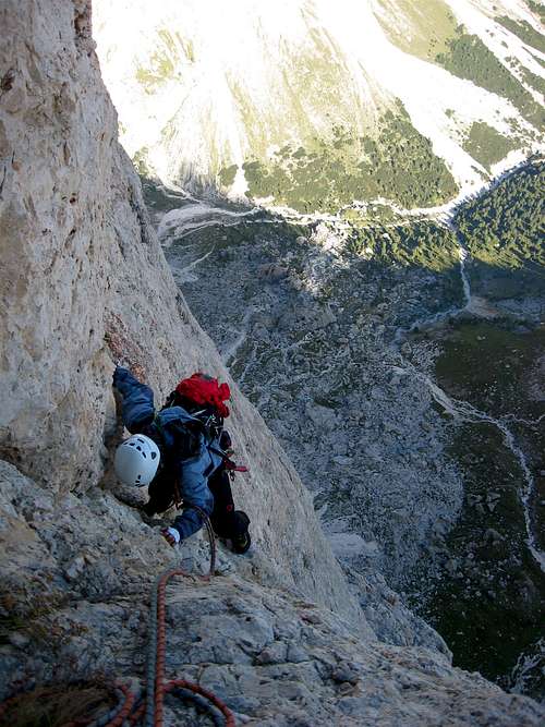
Steger upper pitches
Route report
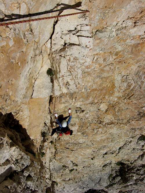
L1 - Climb a few meters a dihedral just to the right of the belay. Slanting left to the base of the obvious yellow dihedral. Belay with 2 pegs on a small terrace on the left. IV, 20 m. L2 - Climb the yellow dihedral which becomes an overhanging crack. Here move left and belay on 2 pegs. IV+, V, 40 m. An intermediate belay possible. L3 - Traverse left for about 4 m. and climb up to a niche; exit right and continue always slanting right take the crack again, where is the belay on 3 pegs IV, V, V+, 20 m. L4 - Slanting right to take another parallel crack; when the crack is widening into a chimney belay on the left on 2 pegs. IV, 15 m. L5 - Continue in a gully towards an overhang. Bypass it to the left and then continue following the left crack. Belay at its end in the gully on 2 pegs. IV+, 45 m. L6 - Up the gully reaching a yellow dihedral (the variant "Vinatzer"). Here slanting right climb a sloping ramp up to the belay on 2 pegs. III, III +, IV, 1 hole, 1 intermediate belay possible. L7 - Climb the crack above the belay and then on easier rocks reach a deep chimney.Belay on outcrop. IV, IV +, III, 40 m. L8 - Climb the chimney overcoming some jammed blocks, then taking the right branch to the belay on 2 pegs at the end of the chimney. IV+, V-, 40 m. L9 - Up slanting right without a compulsive route for about 40 m., then belay on a big hole. II, III, 55 m. L10 - Slanting slightly to the right, climb a wall with good holds getting to a terrace. Reach the bottom of the wall above and belay on another hole. II, III, 45 m. L11 - Traverse left along the terrace, reaching a small dihedral. Here climb slanting left, reaching the belay near nother one. IV +, IV, 40 m. L12 - Climb a shallow corner above the belay, at its end climb the slab above, then move left to the tiny belay on 2 pegs. IV +,50 m. L13 - Climb slanting left up to overcome the overhanging yellow band. Then continue straight to the belay on 2 pegs. V-, IV+, 35 m. L14 - Heading right climb a yellow blade. At the end climb to the left, then return right to belay.IV+, V, 40 m.
L15 - Climb the wall above the belay, at first moving right, then slanting left to the belay on 2 pegs near an outcrop detached from the wall. IV +, 25 m.
L16 - Up at first to the right, then return left to the base of the deep ending chimney. Belay on 3 pegs inside the chimney on the right wall. IV+, V, 20 m.
L17 - Climb the chimney until it ends and belay on an outcrop on the summit ridge. Belay to be equipped. 40 Mt., IV, V, 40 m. On easy rocks along the summit ridge reach the summit. I, II, about 150 m.
Descent: easy along Catinaccio Normal route (II grade UIAA). From the top follow the numerous cairns along the crest NW direction, reaching a vertical wall and the first abseil anchor.
On the summit at sunset in the Seventies
Do a 20 meters abseil and continue along the ridge, getting to a rocky notch. From here three equipped abseils (40 + 45 + 20) West direction (towards Ref. Santner) lead to the basal scree. From here to Rifugio Passo Santner, from where the trail descent to Rifugio Re Alberto, then to Vajolet and Preuss huts.
Essential Gear
Rope 2x50, helmet, quickdraws, a complete set of friends, excentrics, slings,
Red Tape
No fees no permits required. Cima Catinaccio is located inside the Natural Park Sciliar-Catinaccio and Latemar. This area, shared between the provinces of Bolzano and Trento, is one of the nine mountain systems of the Dolomites acknowledged as UNESCO World Heritage Site. It is one of the most important systems worldwide for the study of the stratigraphy of the Triassic, in reason of the plenty of fossils on Alpe di Siusi, the relationship between carbonate and volcanic sediments, and the fact that the outcrops are easily accessible. Catinaccio, with the stunning Vajolet Towers, forms a series of peaks and sharp needles showing the movement of an island which sank into the sea 240 million years ago. More info about Dolomiti Unesco World Heritage here: Dolomites living mountains
Open: from June to the end of September - from Christmas to Easter open during the day (no overnight)
Size: 43 persons
Getting There: by walk from Soial, alternatively by the chair-lift station in Pera di Fassa to Ciampedie or cable-car from Vigo di Fassa, then on foot (half a hour)
Getting There: by walk from Soial, alternatively by the chair-lift station in Pera di Fassa to Ciampedie or cable-car from Vigo di Fassa, then on foot (half a hour)
Parents refers to a larger category under which an object falls. For example, theAconcagua mountain page has the 'Aconcagua Group' and the 'Seven Summits' asparents and is a parent itself to many routes, photos, and Trip Reports.

 7793 Hits
 82.48% Score
 15 Votes