
-
 20503 Hits
-
 86.76% Score
-
 23 Votes
|
|
Route |
|---|---|
|
|
34.72310°N / 98.74735°W |
|
|
Hiking, Scrambling |
|
|
Spring, Summer, Fall, Winter |
|
|
Overview
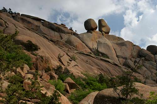
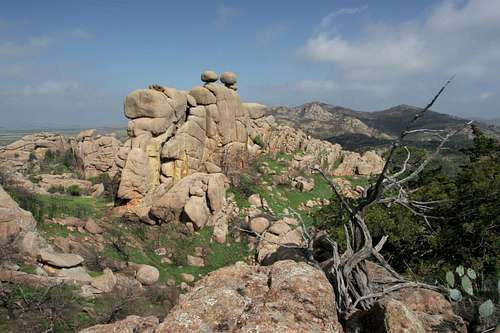 The Crab Eyes
The Charon’s Garden Loop takes in a substantial slice of the best Oklahoma’s Wichita Mountains have to offer. It may even be argued that this hike is the finest and most scenic hike in the state of Oklahoma. While one’s first reaction might be “that’s not saying much”, one ought to examine the highlights encountered on this grand tour of the Charon’s Garden Wilderness. This loop mixes easy hiking with some rugged scrambling route-finding through a confusing maze of granite domes, canyons and boulders. Along the way, the route passes the Crab Eyes, an amazing balanced rock formation. Following this, the loop passes through the heart of the Charon’s Garden Wilderness, some of the most tortured and scenic terrain found anywhere in the Plains. This includes a chance to climb Twin Rocks Mountain, which provides great views of the wilderness. A longer variation permits exploration of Styx Canyon and an ascent of Granite Mountain. In addition to the granite wonderland, the route passes by the prettiest waterfall in the Wichitas, a gurgling creek with smaller cataracts, and beneath the Apple and the Pear, a fantastic pair of houses-sized, fruit shaped boulders. From there, it is possible to climb either the Valley of the Boulders, a canyon filled with massive rocks and hidden rooms or Elk Mountain, one of tallest peaks in the Wichita Mountains. Either way, this is one of the great hikes of the entire Plains region, so much so that one can easily forget that there is hundreds of miles of flat earth surrounding these unexpectedly ragged mountains.
It is important to note that this description endeavors to be accurate but that the nature of the Charon’s Garden Wilderness is such that one must be prepared to do some serious route finding on one’s own. A good map is a must. This is some extremely rugged and potentially confusing terrain.
Route Description
 Bison en route to the Crab Eyes
Once at the base of the column, there are numerous climbing routes to the top. For non-technical climbers, the north end of the column tapers off gradually and it is possible to climb to the top. One must first ascend a short crack and then simply walk up the long granite rib to the top.
 The route to the Crab Eyes passes through the valley below
Getting to the Crab Eyes has been almost entirely on-trail. Once at the Crab Eyes, the route becomes more difficult and astute route finding is necessary. Directly south of the Crab Eyes there is a small granite ridge. Surmount the ridge and descend down the south side into a boulder and juniper filled basin. So jumbled is the terrain in this area it is difficult to discern the true nature of the basin. The basin at this point is the intersection of two large, nearly perpendicular gullies. Interestingly, these gullies extend for a significant distance through the heart of the Charon’s Garden Wilderness. If one followed the gully leading to the south, it would ultimately widen into Styx Canyon, one of the larger valleys in the wilderness. To continue on the route, proceed up the gully to the east. These gullies are filled with junipers, post oaks and large boulders so progress may be slow.
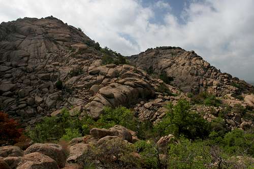
Climbing Twin Rocks Mountain
 The route past Twin Rocks Mountain
If one desires to get an aerial view, there is a good opportunity to ascend Twin Rocks Mountain before proceeding east and completing the loop. Instead of heading up the eastward gully, follow the southward gully a hundred yards or so. Search for a smaller, narrow gully on the left hand side that climbs steeply upward to the southeast. This is the easiest route to the summit of Twin Rocks Mountain. In truth, the sides of the mountain can be scaled at any point, but this is the most obvious route. Once on the summit, the views are excellent. Elk Mountain and Mount Lincoln are obvious highlights to the east. Sunset Peak and the North Mountain Wilderness (a large wilderness in the Wichitas set aside solely for animal use) are visible. Immediately to the south, across a deep chasm is Granite Mountain, another excellent peak in the Charon’s Garden Wilderness. To the west, the wilderness area stretches out in a tortured pile of pink granite. Beyond that, the Plains stretch out into nothingness, punctuated by occasional protrusions of the lesser Wichitas.
Route to Charon’s Garden Trail
 Looking west from Twin Rocks Mountain
To continue on the route, resume passage through the eastward gully. The route rises quickly, mostly by ascending boulders choking the gully. There is a low, almost imperceptible saddle after which the gully begins to descend. Continue down the gully 0.5 miles. As one proceeds, the route encounters fewer boulders and becomes increasingly wooded. At times the trees do a good job of impeding progress but the route is always pretty will defined. Eventually the gully will level off and widen significantly. It is obvious at this point that one has left the rugged domes of the interior of the wilderness behind. It is possible to travel over a grassy ridge to the left at this point, shaving a bit of distance off 0.25 miles of the route. However, if one wants to proceed along the gully, this is a possible route too. Both routes are skirting the edge of a low grass covered dome. If one continued along the gully to the south it will eventually lead to Post Oak Lake. Whether one climbs the grassy ridge or follows the southern edge of the low dome, the intent is to travel cross country to the east until one intersects the Charon’s Garden Trail.
Styx Canyon/Granite Mountain Variation
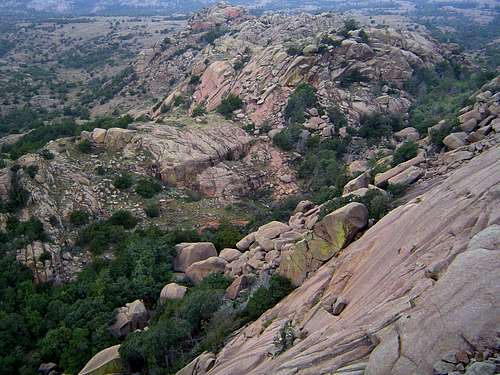
 Styx Canyon
Instead of crossing over to the Charon's Garden Trail at Twin Rocks Mountain, it is possible to add a few miles to the route and explore seldom traveled Styx Canyon, a narrow boulder choked canyon that widens into a hidden, verdant valley in the heart of the Charon's Garden Wilderness. To do so, rather than climbing past Twin Rocks Mountain, continue south, through the narrow canyon. There are numerous permutations of the route as one must navigate through the maze of boulders or cling to the upper edges of the canyon. Eventually the canyon widens significantly, just as it passes the southern end of Twin Rocks Mountain. Here, lower Styx Canyon spreads out to the south with Twin Rocks and Granite Mountains towering high on the eastern side of the canyon and distant Charon's Garden Mountain forming the western perimeter. There is much to explore in the lower canyon, which has a few tanks and a seasonal stream, as well as tall cliffs at the northern end and an interesting granite turret near Charon's Garden Mountain, which can also be summited from here. To continue the loop, flow the eastern edge of the canyon across open grassy terrain. A short climb should lead to a grassy bench between Granite Mountain and a small unnamed granite dome. From here, follow the obvious gully that leads east, up Granite Mountain. This route climbs steadily to a high shoulder with expansive views. It is an easy jaunt over to the summit of Granite Mountain.
 Elk Mountain seen from Granite Mountain
From the summit of Granite Mountain, one continues east to get to the Charon's Garden Trail. A high spur ridge extends east from the summit, forming a kind of basin below the peak. This basin must be traversed and the ridge surmounted before one can descend down into the valley drained by Post Oak Creek. The descent follows the eastern shoulder of Granite Mountain and can be tedious but the views of Elk Mountain and Mount Lincoln are excellent and make the progress more enjoyable. Soon the parking lot at the southern end of the Charon's Garden Trail becomes evident. The shoulder of Granite Mountain basically funnels one to the inlet of Post Oak Lake. From here one simply follows some use trails, the first paths of any kind since leaving the Crab Eyes, to the dam impounding the lake. At this point the southern end of the Charon's Garden Trail is a short walk away, passing through the parking lot to get there.
Options On the Charon’s Garden Trail
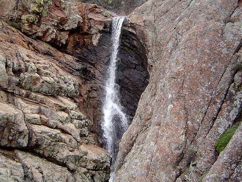 Post Oak Falls
Once one reaches the Charon’s Garden Trail, there are numerous options. The most direct route back to the trailhead is to simply follow the trail north, passing beneath Elk Mountain and through the Valley of the Boulders. A description of the trail can be found here. The trail parallels Post Oak Creek and passes pretty Post Oak Falls. At the falls, it is possible to climb to the top (on either side of the falls, though the left side has the easier route). Once on top of the falls, one can proceed to northeast along the drainage to the large valley between Elk Mountain and Mount Lincoln. This is a grand area, with the Elk Slabs high above and the summit 800 feet overhead. It is possible to turn east from here and ascend Mount Lincoln. To return to the Charon’s Garden Trail, follow the valley west until it intersects the trail.
Completing the Loop
 The Apple and Pear
Whether one opts to follow the Charon’s Garden Trail or climb above Post Oak Falls into the Elk Mountain – Mount Lincoln valley, one will end up at the mouth of the Valley of the Boulders, a canyon filled with massive house sized boulders. While this is fun trek in its own right it leads directly back to the trailhead. If one still has a significant amount of time to spend, the best way to complete the journey through the Charon’s Garden Wilderness is to climb the southwest corner of Elk Mountain and then traverse the summit plateau to the terminus of the Elk Mountain Trail, which leads back to the trailhead.
To do this, there are two routes by which one can summit Elk Mountain. Either way, one must be prepared for about 500 feet of climbing up boulders, slabs and benches. One route departs from the western end of the Elk Mountain – Mount Lincoln valley, up a gully that leads to the back side of the Apple and Pear. Use these large rocks as orientation. The other option is to proceed a short distance up the Valley of the Boulders and then climb up the canyon wall just to the north of the Apple and Pear. While not difficult, it is the more treacherous of the two routes. Beyond the Apple and Pear, continue climbing for another 100 feet or so until the slope levels off and one is on the obvious summit plateau. From this point it is 0.5 miles of hiking over bear granite and grassy areas to reach the end of the Elk Mountain Trail. It is necessary to cross a few gullies but none should pose a serious obstacle. Once at the trail, the views to the east are impressive, taking in much of the northern and eastern Wichitas, including massive Mount Scott. The trail descends the northeast corner of Elk Mountain, reaching the trailhead after 1 mile. Detailed information on the Elk Mountain Trail and routes on the summit plateau and the descent/ascent on the west side is available here.
 Looking down on the Valley of the Boulders while climbing to the summit plateau of Elk Mountain
While there are many areas in the Wichitas unvisited by this route, it does offer a buffet of highlights including bison, fantastic rock formations, the spectacular vistas, exciting route finding, deep canyons and the opportunity to see one of the prettiest waterfalls in the region. This is without doubt, one of the finest hikes to be found anywhere on the Plains, a surprising oasis of rugged, rocky terrain amidst a sea of grass.
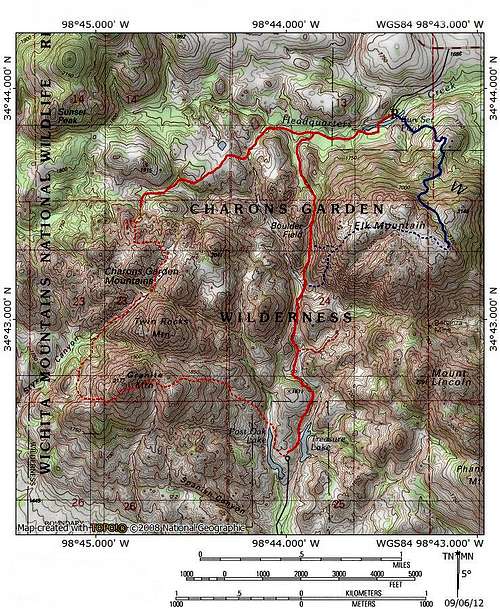
Map
Twin Rocks Mountain Variation Trail Map
Styx Canyon/Granite Mountain Variation
Camping
 Backcountry camping area between the Crab Eyes and Sunset Peak
Doris campground is a few miles away and is a good option if you do want to sleep in the backcountry. Another great option is the group campground on the eastern border of the wilderness. It is much cheaper than the Doris campground and you can head up into the wilderness directly from there if you do not mind some bushwhacking.
Refuge Camping Site
Getting There
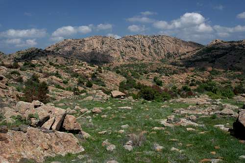
 The Charon's Garden Wilderness from near the Post Oak trailhead
Sunset Trailhead
From I-44 take Highway 49 (exit 45). Go west 10 miles to the Refuge gate. Proceed through the park, past the visitors and turn right at the stop sign. Continue west and turn left into the Sunset Picnic Area.
If coming from Highway 62, take Highway 115 (Cache exit) north to the Refuge Gate. Proceed north. The road will turn west and continue until turning left into the Sunset Picnic Area.
Post Oak Trailhead
Although this route is described beginning at the Sunset trailhead at the northern end of the Charon's Garden Wilderness, it is possible to hike the loop from the wilderness area's southern trailhead.
From exit 45 on I-44, head west on Highway 49 for 14.5 miles. At the junction, turn right to stay on Highway 49. Continue another 5.7 miles before turning left onto Indiahoma Road. After 3.1 miles turn right to stay on Indiahoma Road, proceeding another 1.8 miles to the signed turn for the Post Oak trailhead, which is about 0.5 miles up the road.