My wife and I were on a short road trip of a vacation. We started at home in Medford, Oregon a few days earlier and in the early afternoon on Monday July 2, 2007 we drove through the quaint little town of Joseph, Oregon and on to Wallowa Lake. Wallowa Lake is a vacation destination as it sits at the foot of the Wallowa Mountains (The Oregon Alps) and has lots of camping, recreation, and vacation facilities.
We pulled into the historic Wallowa Lodge on a whim and asked if they had any rooms available. Since this is 4th of July week, we expected them to laugh at us. Surprise! Surprise! We got our choice of rooms at $99 a night. We decided to stay 2 nights. The lodge only has 22 rooms, so we felt fortunate to get accommodations.
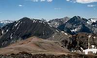
After moving into our room we headed to the Wallowa Tram and took the tram ride up to the top of Mt. Howard. It was a beautiful day and we had fantastic views into the Wallowa Mountains. Across the valley from Mt. Howard sits Chief Joseph Mountain and that was my goal for hiking the next day.
After enjoying the tram ride, we had an expensive dinner at the lodge. The dining room was not crowded, the service was excellent, and the food was superb. Thee atmosphere was comfortable and even romantic, so my wife and I enjoyed our dinner even though it was expensive.
The next morning, we got up early and were the first ones in the restaurant. We ordered their hazelnut pancakes which were HUGE. I ordered 2 of them and could only finish about half the meal. After doing this massive carbo-load, my wife drove me to the marina (about .5 mile) and I found the trail described in the Route
First Chute .
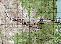
It was going to be a warm day, so I took 5 liters of water/Gatorade with me. I didn’t know if there would be any water available on the trail (there isn’t any). The trail is easy to follow out of the marina and in a couple hundred yards there was a fork to the right that was marked with red flagging tape with “Chief Joseph Trail” written on the tape. So far the route description was right on the money and I headed up the right fork.
This part of the trail is a little overgrown with brush, but it is easy to follow. Soon it was climbing steeply with a few switchbacks, but mostly straight up the hill. I made good time and after climbing about 1,000 ft I came across the longer Chief Joseph Trail that starts at the top of the road next to the Wilderness Boundary. I followed the directions in the First Chute Route description and sure enough the trail I was on crossed this other trail and continued straight up the mountain. This crossing again was marked with some flagging material.
![Chief Joseph]()
I kept heading up the mountain mostly under a forest canopy for which I was grateful because it was already hot even though it was only mid-morning. After climbing about another 1,000ft, I again came to this other trail that meanders all over the mountain. This intersection was again marked with flagging material, but my trail dead ended on this trail. My choice was to go left or right. I went left because that’s where my GPS was pointing me toward Chief Joseph Mountain.
![Chief Joseph]()
The forest opened up now and I was hiking along some sage brush covered slopes. After only about a quarter mile, the trail switchbacked sharply to the northeast and my GPS informed me I was at a waypoint I had set where I should leave the trail. I couldn’t see the First Chute from here because there were trees blocking all visibility south and west. I could see where other hikers had left the trail and started their way cross country towards the chute. I tried to follow their trail as it climbed to the southwest, but soon I lost the trail in the tall grass and wildflowers. I still couldn’t see any chute, but generally I had good idea where it should be.
![Chief Joseph]()
I kept climbing and traversing to my left until I could see a rocky cliff on my left. I decided to just follow the cliff up until it opened into the chute. This worked out well. I climbed about 400 feet in elevation from the main trail before I picked up what looked like a well used rocky climbers trail in a forested area. I followed this trail out of the forested area and into the First Chute. The First Chute has low growing vegetation with a steep scree trail heading up the left side of the chute.
:]
I tried to stay out of the scree and climbed on the left side where the footing was better and made my way up the chute. This is a long steep climb that tops out on the ridgeline at about 7,800ft. It is about 1,400ft above where I left the main trail system.
Now the world opened up to me. I was above treeline and could see great distances in all directions except west towards the summit of Chief Joseph Mountain. I still had 1,800 ft to climb and I couldn’t see very far up the ridge. The footing was good, and there is a faint climber’s trail, so I started climbing towards the summit.
What a beautiful climb! The views of
Hurwal Divide are fantastic. As I climbed I caught views of https://www.summitpost.org/mountain/rock/151103/sacajawea-peak.html> Sacajawea,
Matterhorn, and
Eagle Cap among dozens of other peaks in the Wallowa Mountains. I kept climbing, finding my way around the rocky part of the ridge, but mostly just staying right on the crest of the ridge and moving up.
Near the top, the pink color of the rocks on the ridgeline are really unique and then the chocolate brown top knot comes into view and provides a vivid contrast for your viewing pleasure. I arrived on the summit a little over 4 hours after I started and I took a few minutes to take pictures, eat lunch, and call my wife on the 2 way radio. What a beautiful day and beautiful climb.
Soon I had to leave the summit and head back down to Wallowa Lake far below. I didn’t have any problems finding my way down until I was at the bottom of the chute and had to find the trail. I flailed around in the forested area for a while before I used my GPS to find the route I used in coming up. My GPS saved me some work again!
My wife met me at the trailhead. The entire hike took me under 8 hours, was just under 8 miles, and I gained just over 5,300ft in elevation (there are a few minor ups and downs on the ridgeline). This was a great hike, but be prepared for all the elevation gain and take enough water for the entire hike.
Comments
No comments posted yet.