
-
 12455 Hits
-
 88.61% Score
-
 27 Votes
|
|
Area/Range |
|---|---|
|
|
34.11161°N / 118.92643°W |
|
|
Hiking, Sport Climbing, Bouldering, Aid Climbing, Mixed, Scrambling |
|
|
Spring, Summer, Fall, Winter |
|
|
Overview

|
|---|
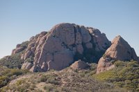
Circle X Ranch is part of the Santa Monica Mountains National Recreation Area administered by the National Park Service. It is located on the western part of the Santa Monica Mountains and comprises of 1,655 acres on the border of Los Angeles and Ventura counties. The park boasts more than 15 miles of trail plus a public campground. Half a century ago the land belonged to a number of gentlemen ranchers, including movie actor Donald Crisp, who starred in “How Green was My Valley”. Members of the Exchange Club purchased the nucleus of the park in 1949 for $25,000 and gave it to the Boy Scouts. The emblem for the Exchange Club was a circled X - hence the name of the ranch. The area is host to the highest peaks in the Santa Monica Mountains with Sandstone Peak being the high point at 3,111’. Despite its name Sandstone Peak consists of volcanic rocks like most other peaks in that area.
Trailheads
There are several trailheads off Yerba Buena Road close to the Circle X Ranch main house (Lat:34.11161 Lon:-118.92643), which is located about 5.5 miles from Pacific Coast Highway on Yerba Buena Road in Malibu. Heading north on PCH, turn right onto Yerba Buena Road and continue to the top until you reach Circle X Ranch. Or alternatively, from the 101 Freeway in Westlake Village, exit on Westlake Blvd , and follow it south for several miles as it merges with Mulholland highway (turn right). Turn right onto Little Sycamore Canyon and it will become Yerba Buena Road as you cross the county line.
Mishe Mokwa Trailhead (Backbone Trailhead): The trailhead is 1.7 miles east of the Circle X Ranch on Yerba Buena Road. The actual Mishe Mokwa trailhead is not located on Yerba Buena Road. The Mishe Mokwa Trailhead can be reached from the Sandstone Peak Trailhead (via Connector Trail) or the Backbone Trail off Yerba Buena Road.
Sandstone Peak Trailhead: The trailhead is about 1 mile east of the Circle X Ranch on Yerba Buena Road.
Canyon View Trailhead:
Circle X Ranch Main House: The Grotto trail starts from here
Peaks (selected)
Most of the highest peaks of the Santa Monica Mountaints are within the Circle X Ranch area, including its highpoint, Sandstone Peak. Officially, it seems that Tri-Peaks just lies outside of the western border of Circle X Ranch within Point Mugu State Park. However, since Tri-Peaks is part of the Boney Mountain Plateau and routinely accessed from within the Circle X Ranch it is still mentioned on this page.
| Sandstone Peak | Tri-Peaks (Pt. Mugu SP) | Exchange Peak | Big Dome | Boney Peak |
|---|---|---|---|---|
| 3,111’ | 3,010’ | 2,950’ | 2,913’ | 2,825’ |
| Latitude: 34.1203; Longitude: -118.9309 | Latitude: 34.1222; Longitude: -118.9506 | Latitude: 34.1147; Longitude: -118.9462 | Latitude: 34.1246; Longitude: -118.9472 | Latitude: 34.1164; Longitude: -118.9403 |
 |
 |
 |
 |
 |
Trails
 Trailmap
Sandstone Peak via Mishe Mokwa Trail: 6 miles round trip, strenuous - The Mishe Mokwa trailhead can be reached from the Sandstone Peak Trailhead or the Backbone Trailhead. From the Sandstone Peak trailhead use the trail from the parking lot and continue east on the connector trail (which is part of the Backbone Trail) to Mishe Mokwa Trailhead. From the Backbone Trailhead off Yerba Buena Road take the trail about 0.3 miles to the Mishe Mokwa Trailhead. Follow the Mishe Mokwa Trail as it contours on the south side of Carlisle Canyon past Echo Cliffs and Balanced Rock. The trail dips into Carlisle Canyon near Split Rock and then continues uphill until it connects again with the Backbone Trail. Continue east towards Sandstone Peak and use the Sandstone Peak Trail back for a loop. Only hikers are allowed on the Mishe Mokwa Trail.
Sandstone Peak via Backbone Trail: 3 miles round trip, strenuous - Starting at the Sandstone Peak Trailhead at an elevation of 2,030 feet, this trail provides views of the Conejo and San Fernando Valleys, as well as the Pacific Coast. It's the most direct and shortest trail up to Sandstone Peak. You can continue back on the Mishe Mokwa Trail for a loop.
Canyon View Trail: 1.9 miles, easy to moderate; no bikes - This trail can be accessed from three points: the Group Campground via the Grotto Trail, the trailhead 0.3 mile east of the Ranger Station on Yerba Buena Road, or the Sandstone Peak Trailhead.
Grotto Trail: 3.5 miles round trip, moderate to strenuous; no bikes, no horses - From the Ranger Station, walk down to the Group Campground where the Grotto Trail begins. This trail traverses hillsides and leads down to the West Fork of the Arroyo Sequit. The trail is downhill from the Ranger Station, which means an uphill return. The Grotto area is rugged terrain; be careful and wear appropriate hiking attire. The last 1/8 mile is through an unimproved streambed and dogs are not allowed.
Information
Camping is restricted to the Group Campground only. Permits are required.
Dogs must be on a 6’ or shorter leash at all times. For the health and consideration of others, clean up after your pet. Dogs are not permitted in the backcountry of Point Mugu State Park.
Firearms, weapons, nets, and traps are not allowed in parklands.
Natural and historic features including rocks, plants and animals are protected by law and may not be collected or disturbed.
Fire is a constant danger. Open fires are prohibited. Charcoal and gas stoves are allowed in the Group Campground only. Smoking and all fires are not permitted during times of high fire danger. Smoking is not permitted in Point Mugu State Park.
Bicyclists must ride courteously and yield to hikers and equestrians. Hikers must yield to equestrians. Bicyclists and equestrians are allowed on designated trails only.
Water that comes from streams is not safe to drink due to possible contamination or the presence of the giardia protozoan.
Trail closures will be in effect during and following extreme weather or hazardous conditions.
National Park Service
Santa Monica Mountains
National Recreation Area
401 West Hillcrest Drive
Thousand Oaks CA 91360
www.nps.gov/samo
Facilities
Group Campground
Campground is accessible by vehicle.
Reservations required:
Call 805-370-2300 x1702
Limit of 10 to 50 persons.
Fee: $2 per person per night (Golden Age and Golden Access passport discounts do not apply).
Facilities: Picnic tables, vault toilets, drinking water and fire grates. (Charcoal fires are permitted in fire grates or personal barbecue grills. Gas stoves are permitted. Wood or compressed log fires are prohibited due to fire hazards.)
Check out time: Must vacate site by noon or pay for another day of camping.
Maximum stay: 14 consecutive days and no more than 30 days per calendar year.
Quiet hours: 10pm to 6am.
Backcountry camping is not available.
Ranch House
This facility includes a meeting room for 75 people, a kitchen, restrooms with showers, a fireplace and lounge area. No overnight accommodations. Available through reservation/ special use permit. Call 805-370-2308