Introduction
Early Monday morning the 24th, I entered Kings Canyon via Kearsarge Pass with 40 pounds of necessities and 17.3 pounds of photography equipment. My vocation is that of a wilderness landscape photographer. For over 30 years, I have been exploring the eastern sierra escarpment within the confines of Kings Canyon and Sequoia National Parks (SEKI). Because of my passion for exploring SEKI, I'm inspired in attempting to convey the moment.
The Itinerary
Equipped with a Delorme InReach satellite communicator and their PN-60w GPS, solo mountain adventures are becoming safer with advancements in lightweight satellite communications technology. Back in a day, I carried a 4-pound EPIRB (Emergency Position Indicating Radio Beacon) on an ocean kayak. Now, it is a two-way text communicator weighing under a pound. Got to love that!
Trip ItineraryGetting Prepared
Half of the fun is in making the plans, provisioning, and anticipating the next mountain adventure. The objective this year was finishing where I had left off the previous after getting chased out of the mountains prematurely under the threat of an early season snowstorm! With the taste of last year’s frustration persisting, I decided to move this year’s trip up 10 days on the calendar and undertake an ambitious loop entering and exiting via Kearsarge Pass (at least ambitious within the context of my 55-year old body). As with many Sierra backpack trips, this one begins in Lone Pine at the Dow Hotel. It was a Sunday afternoon, September 23, 2012, after settling into my room that I began anticipating the challenges of what was in store.
Camping in Kearsarge Basin
I love the craggy Kearsarge Pinnacles and appreciate Kearsarge Pass being a relatively easy entrance over the eastern Sierra escarpment. It was windy, my first day, but finding a reasonably sheltered campsite was not a problem. During the more active summer season, finding a campsite in this location is often frustrated by a large number of visitors, but not in the quieter fall season of late September. The following day was a bitter cold morning with blue skies and a bite to the wind. I was lethargic as usual, worn by the previous day’s 7-mile entrance under a full pack in the face of sudden altitude gain. All considered, I felt pretty good, or so I thought! Descending to Vidette Meadow from Kearsarge turned into an exhausting effort. It is a steep descent with a beautiful view of the Kearsarge Pinnacles’ southern face, but I was going slow and feeling more lethargic than usual. Upon reaching Vidette Meadow, I turned downstream alongside Bubb’s Creek. I was having doubts about the second day’s leg of 10 miles. With 3000 feet of descending and another 2000 of climbing to Lake Reflection, chances of making the hoped for destination were looking dim. Fortunately, I experienced a second wind while climbing alongside East Creek and ended up with time to spare for making camp before sunset.
![Kearsarge Pinnacles]() Kearsarge Pinnacles from Kearsarge Basin
Kearsarge Pinnacles from Kearsarge BasinLake Reflection
At 10,000 feet, Lake Reflection has an impressive amount of treeless, steep granite topography for such a low altitude lake. And it is a very large lake with massive surrounding peaks. The ridge defining the GWD (Great Western Divide) is awesome and forms an impressive backdrop to this remarkable location. Two nights at Lake Reflection would give my legs a chance to recuperate before negotiating the planned cross-country phase beginning on day four. I truly enjoy going off trail, but I also respect the potential for increased danger, and having a rested pair of legs would serve me well at this early juncture in what was to be a 10-day excursion. The rest also provided a fine opportunity to do laundry and work my camera. A brief swim the morning of day 3 left me feeling refreshed.
![Lake Reflection]() Lake Reflection
Lake Reflection![View Towards Longley Pass]() Looking towards Longley Pass from Lake Reflection
Looking towards Longley Pass from Lake Reflection Longley Pass
All to often, I manage finding approaches to cross-country passes proves more difficult than what is revealed with the benefit of hindsight. This annoying habit had me a bit nervous the day before negotiating Longley Pass, which has a good name, because it also turned out to be one very LONGLEY day! I could have made the pass in under four hours had the batteries to my GPS batteries survived only few minutes longer. It was alongside a lake at 11,600 feet where I could see the pass when the GPS failed, or so I thought I saw the pass! As it turned out, at around 12,200 feet, I had the sinking feeling that comes with reckoning I’m in the wrong place! After cresting what turned out to be a false pass, I entered a craggy and giant cirque with no exit visible! It was a daunting view of Mt Jordan and it was painfully apparent, I was in no-man’s land. Okay, off with the pack, in with a new set of batteries, and sure enough, I had veered to my left about 200 yards too early. The error necessitated an 800-foot descent back to lake 11,600. Giant boulders surrounded me in an unfriendly glacial moraine. I was growing weary and running low on water. It was very annoying to say the least, I was not happy with my failure to confirm an accurate location with a fresh set of GPS batteries when I should have. Correcting this error added at least 90 minutes to an already extremely difficult terrain. It was not until 4:00 PM before finally cresting Longley Pass. Only an hour and a half of adequate daylight remained for locating a campsite along the upper reaches of Cunningham Creek.
![Lake Reflection Aerial]() Aerial View of Lake Reflection
Aerial View of Lake Reflection![Longley Pass]() Longley Pass... Almost there
Longley Pass... Almost there
As it turned out, my folly that day did not stop with errant off-trail navigation! I had been foolish in an attempt to consolidate space by putting my spare canister of white gas into the BearVault while breaking camp at Lake Reflection. The O-ring on this canister failed… not a drop of some 200 mls of white gas remained in the canister; it had all drained and seeped into every baggie of trail mix contained in the BearVault! Kirkland’s tasty fruit and nut trail mix constituted 30% of my daily caloric intake... not so tasty when served with white gas. Out of desperation to extend an already limited food supply, I decided that only the banana chips were beyond edible. It was a serious health-conscious challenge, but I was determined to finish the trip successfully this year. It was not long before I began burping white gas; I should have taken a match to those first white-gas burps. Initial fears for an early death dissipated as the days passed. Hunger will definitely change the equation when it comes to what one is willing to eat! Fortunately, the foil-covered dehydrated meals and power bars where contamination free.
Descending the east side of Cunningham Creek proved reasonably easy with minimal bush whacking. My legs suffered more from granite abrasion while negotiating Longley Pass than suffered in one stretch of knee-high Manzanita. Getting back on trail was a welcomed relief. Colby Lake was now within relatively easy reach. Originally, I had planned to maintain elevation and traverse the GWD in order to reach Colby Lake, but I had had enough unforgiving granite for the time being.
![Cloud Canyon]() Cloud Canyon
Cloud CanyonColby Lake
![Whale Back]() Wet Meadow towards Colby Pass
Wet Meadow towards Colby Pass
Stopping at Colby lake was in the plans from the beginning, but I had no idea how beautiful a high sierra lake it is. I arrived at a reasonably early hour of 4:30 PM. After a quick camp setup, I got to soak in the beauty of the place while working the camera. It was pretty enough to consider staying a second night, but I wanted to get a little more ahead of schedule given the precarious nature of these lengthy backpack trips. A very light rain punctuated the fifth evening while pitching my tent on level ground near the shores of Colby Lake. There is something very special about such a beautiful location with the absence of fellow campers. In absolute solitude, surrounded by 13-thousand foot peaks, and alongside the tranquility of a large high-sierra lake, life's irrelevant details simply fade away.
![Colby Lake]() Colby Lake
Colby Lake
I departed from Colby Lake the following day and headed to an uncertain location over Colby Pass. I was considering a lakeside campsite just under 11,000 feet above Gallats Lake. After cresting the pass, I took my limited time to explore the area and lost confidence in the worthiness of such an effort. Instead, I continued to a small jewel in Sequoia National Park called Picket Creek. Entering the lowest lake formed by Picket Creek is like leaving the park and entering a different world, one that is even more surreal than that just left behind.
Picket Creek
![Picket Creek Campsite]() Picket Creek Campsite
Picket Creek Campsite
One nagging injury at this point in the trip was an ulcer developing under the bottom sack of my backpack due to the location of the BearVault. It was my first year using this brand of a bear-proof container. BearVaults are larger than the original bear-proof food storage canisters that go by the brand name, “Backpacker’s Cache”. This increase in size makes for a more pronounced bulge when storing the bear canister in the bottom sack, adding enough extra pressure to work up a sore underneath the lower edge of the waist belt. The larger size also makes it possible to store the necessary provisions for a 10-day solo backpack trip. It was time to relocate the BearVault into the middle-sack compartment.
Other than the sore in my low back and a mild left quadriceps strain, I was slowly feeling better by the day. Ibuprofen made this possible. I am a regular abuser of that amazing NSAID while in the mountains. The dose varies with the severity of the pain. It acts like a pain-relieving lubricant for the knees.
![Red Kaweah]() Red Kaweah
Red Kaweah
The two nights spent at the Picket Creek campsite provided for a much-needed rest and time for doing another load of laundry, but equally important was an opportunity to fulfill one of the more personal trip objectives. I had brought a pinch of my Mom’s ashes on this trip. Having made the decision at Colby Lake that if I were to make Pickett, I’d place these sacred ashes by a particular tree I have grown to appreciate over the course of the last few years. It was a beautifully appropriate opportunity and one I will cherish the remainder of my days.
![Memorial Tree]() Memorial Site
Memorial Site
It was while staying at Picket Creek, I could no longer tolerate a growing sense of hunger and surrendered to the discomfort by eating 11th-day rations. This trip was consuming more calories than anticipated; I could finish in 10-days instead of the preferred 11, but no less than 10 days without risking over exertion and inviting an increased potential for injury or accident. Because of this decision, Picket Creek was to be the final two-night campsite.
Getting Easier
Leaving Picket Creek the day after celebrating my mother’s life made for an emotional departure. The Kearn-Kaweah River descent makes for one of the most colorful and vast trail stretches within Sequoia NP. Junction Meadow is encountered at the bottom, and finally the Kern River crossing before beginning the climb along Wallace Creek, which is an equally beautiful stretch of four miles. Junction Meadow serves to join several trails at 8000 feet in bottom of the Kern Canyon. It is a meadow full of massive red-barked Jeffery pines serving up extraordinary contrast to the likes of a granite cirque forming the Picket Creek drainage. It is as visually striking as scenery gets making it all the more difficult to keep an eye on the feet and avoid tumbling into a header!
![Junction Meadow]() Junction Meadow
Junction Meadow
Upon intersecting the John Muir Trail, I headed North into new territory towards Forester Pass. I had been in the area to where I was next headed on just one other occasion via an entrance over Shepherd Pass, but never over Forester.
![JMT]() JMT above Tyndall Creek
JMT above Tyndall Creek
By now the pack weight was nearing a 10-pound reduction, and the old legs appreciated the difference. Arriving into a large camping area at Tyndall Creek and nearing 5 PM, I figured I’d be in good shape for making Forester the following day and proceeded with setting up campsite number 6. It was a forlorn location, but it was not only convenient, it also had readily available water and ample flat ground.
Forester Pass
![Look South from Forester]() Forester looking South
Forester looking South
After the previous day of rather bland scenery, I did not expect much in the way of grand vistas while cresting Forester, a 13,000-foot pass. To the contrary, I was impressed with the extraordinarily beautiful views while looking south from the pass and being able to identify each of the Kaweah Peaks that formed an amazingly colorful mountain backdrop behind Picket Creek. It certainly put the enormity of space into a more accurate perspective.
Bubb’s Creek
![Vidette Meadow]() Towards Vidette Meadow
Towards Vidette Meadow
Descending Forester Pass to 11,000 feet took me off trail as I followed a coyote going over a ridge. I figured it was as good an omen as any to veer off trail and shortcut the approach to Golden Bear Lake. It was an interesting sight looking up from this lake towards the barren granite forming the massive Center Basin. Golden Bear Lake itself is indeed gold in color! A very shallow lake with pristinely clear water, the lake bottom takes on a vibrant and dark-yellowed hue. Although I had found a nice campsite, I was enticed to continue descending the headwaters of what becomes Bubb’s Creek. It was approaching 5:00 PM when I came upon a fantastic location along Bubb’s with a great vista of Vidette Meadow in the distance as well as a nice view of the south-facing Kearsarge Pinnacles where I could better enjoy one more sunset on the trip’s final evening.
I found level ground for a decent campsite, pitched the tent and retired for the night gratified this trip had not overextended my capacity for endurance. This was to be my longest unassisted solo trip nearly completing a 30-year effort exploring the entire eastern escarpment within Sequoia and Kings Canyon National Parks.
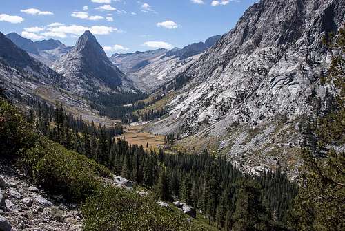
Efforts in “fine art” Sierra landscape photography are met with occasional success in my hands. Success was not to be had on this amazing trip, but I was entirely content all the same. (The primary image in this report was made during a previous trip.)
The Exit
Exiting the mountains after any length of stay is always a day to cherish. Longing for a soft and level bed, and enjoying a hearty, post-trip meal are benefits routinely savored following the rigors of carrying one’s most basic of life’s necessities on one’s back. Kearsarge Pass was easy and quick. The legs were fatigued without injury and unlike the memories, the abrasions were already beginning to fade.


Comments
Post a Comment