
|
|
Route |
|---|---|
|
|
40.27500°N / 111.9398°W |
|
|
HIke |
|
|
Half a day |
|
|
Mainly a walk up |
|
|
Approach
UPDATE: Please note that this information was placed in 2005 and needs to be double checked for accuracy since construction in the area has changedsome of the information contained below. I will visit and recheck this information in the near future and make corrections as needed. (April 2009)
As mentioned in the "getting there" section, find your way to the coordinates listed there just off of Utah highway 68. (7 miles from the junction with highway 68 and Redwood road. You'll see a church on the right side and you can park your car there and start your effort. The housing area ends with a road that forks to the right to a gravel pit, posted "no trespassing" so take the left fork and begin walking. A car can drive this road but it has some rough spots that a low slung vehicle would be threatened by. However, since the main goal of this climb is to get some good conditioning, I recommend the walking from the area of the church so this would become your trailhead. Driving the road can cut off a mile of walking and save about 600 feet of elevation gain.
 |  |  |  |
Route Description
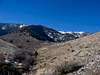
Whether you are walking or driving, stay on the road and in about a mile it curves to the right towards some powerlines. A jeep road takes off toward the powerlines and that is the path you should follow if you are walking. Driving, find a spot (plentiful) and park your vehicle. Follow the road as it heads up towards a ridge that separates Clark and Losee Canyons and stay on it as it trends west but slightly southwest. At about the three mile mark, you will crest the top of the ridge and find yourself on a broad plateau with some antenna towers to the south of you and antenna towers to the north. Looking to the northwest, you will see your goal, the Loran station, evident by its conical elongated shape.Distance: From church 4 miles
From near powerlines 3 miles. Some of the land near the powerlines is posted for no trespassing but I found a way that avoided the
private property issue, you should be able to as well.
Elevation gain: From the church 3100 feet
From near the powerlines 2500 feet.
GPS coordinates
Jeep road junction (park near here if driving)
Coordinate # 1 Where to start onto ridge 5695 feet
Coordinate #2 Making your way up the ridge to 6250 feet
Coordinate #3 Up to near 7000 feet
Coordinate #4 Top of the ridge
After getting to the top of the ridge, aim to the northwest as previously mentioned as the highpoint is obvious thanks to the Loran station on top of it.

The top of the Lake Mountain range has been taken over by this man made marvel, a Loran beacon. The top of the area has been flattened and changed to allow its construction.