Introduction
In the summer of 2003 my family and I piled into the old Ford 250 for another summer week of adventure. We usually had a very loose “plan” for what we would be doing for the week, usually meaning we would pick a direction and start driving that way until we found something interesting to see or do. Living in Preston, Idaho this method meant that we could end up in Idaho, Utah, Wyoming, or Montana depending on the direction we picked. This particular summer our wanderings took us first to Virginia City, Montana. My two sisters and I have volunteered at a living history center in Wellsville, Utah for many years so being immersed in so much history at Virginia City was, well, boring to me. I do like history but I wanted to get out into the mountains, and I wanted to be in Idaho, not Montana. Soon my wish would come true....
After taking the grand tour of Virginia City we made our way back into Idaho and eventually found ourselves in a peculiar place called Copper Basin in Idaho’s Pioneer Mountains. I don’t remember how we came to end up there of all places but I must admit I was secretly delighted
While my family camped at the Starhope Campground my Dad and I decided to take advantage of the situation and do some exploring in nearby Bear Canyon. As we hiked I can remember looking at all the high mountains I was surrounded by and wishing I could stand on each one.
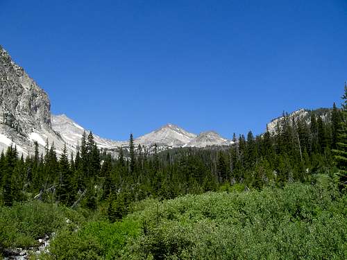
![Broad Canyon View]() Standhope Peak from Broad Canyon
Standhope Peak from Broad Canyon
Somehow Dad and I ended up following what was called the White Mountain Trail which led us North into Broad Canyon. It was there that I beheld a view that would become a lasting image in my mind. I saw
Standhope Peak and
Peak 11887 rising precipitously at the head of the canyon and was filled with a desire to return and sit on top of them. Limited by time and energy, we had to turn around and head home that day but my determination to return to the Pioneers stayed with me. In fact later that summer Dad and I would return to climb Hyndman Peak, the highest in the Pioneers, but it would be five years later during the summer of 2008 that I would finally return to climb Standhope Peak.
This is the story of that trip.........
Packing In
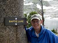
![Brittany at Baptie Lake]() Brittany at Baptie Lake
Brittany at Baptie LakeNow after five years later I’m married to a beautiful girl named Brittany Wilcox (now Brittany Durrant of course ... ;).... ) and living in Boise, Idaho. Although she’s not as passionate about the mountains as I am I can still convince her to come along with me now and again to see if we can squeeze some fun out of the outdoors together. This summer I decided it was time to go back to Copper Basin and get on top of as many mountains as I could. Foremost on my list were Standhope, Peak 11887, Altair Peak, and Big Black Dome. In the end I would only complete Standhope but I would have a wonderful weekend with my wife.
Things worked out so that we had the 3rd and 4th of July off of work and I could see our window of opportunity opening quickly. I waited and prepared patiently for the day we would finally leave. When it came I was ecstatic!
The drive over was uneventful but enjoyable. After a quick stop at Craters of the Moon I was excited to see The Lost River Range as we drove towards the Trail Creek Road leading into the Pioneers. I was rewarded with excellent views of Idaho’s highest mountains. After some time we arrived in Copper Basin. My original plan was to climb Big Black Dome on the way in and spend the night at the Broad Canyon Trailhead but we had a late start on the road so we decided to just head up the canyon and try to get to Baptie Lake before it grew dark. At the trailhead we eagerly unloaded all of our gear and set out on our adventure. The time was 7:12 PM.
The first few miles of the trail were very smooth and fun. We talked and laughed as we hiked through beautiful forests and meadows. About halfway up the canyon though things started to get a little more interesting. Hiking up Broad Canyon requires that you cross the creek that flows through it twice. On our first crossing I had made it across the freezing water without incident when behind me I heard a shriek. I turned around to see Brittany struggling to regain her balance after slipping and losing her sandal in the swift current. Not wanting to risk falling again she kept walking painfully on cold, bare feet to the shore. She had cut her foot on a rock during the fall and was pretty cold an shaken up but otherwise ok. Hoping that her sandal hadn’t gone far downstream, I glanced back at where we crossed. Luckily I saw it stuck in some branches caught on a fallen log not far from our crossing point. I went back into the frigid water and retrieved the sandal. Had it been lost it would have made all further stream crossings very difficult if not impossible.
From here we began to pass below giant cliffs forming the South wall of the canyon. Snow was still hanging on in the shadows and cracks of the rocks, but because of the warm weather much of it had already melted and what was left was melting fast leaving the trail inundated with water in some sections.
![Me at Baptie Lake]() Me at Baptie Lake
Me at Baptie Lake
After crossing the creek, without incident, to the North side of the canyon again the trail started to gain elevation quickly. Brittany was beginning to get tired and it was getting dark fast. According to my map, Baptie lake appeared to be close enough to make it soon so we kept pushing on. After about another hour we could hardly see anymore and we were very tired and hungry, still with no lake in sight. Being on a steep part of the trail only added to the misery as there were no decent camping spots. Finally we rounded a corner and came into a broad meadow containing a small marshy area called Bench Lake on the map. We climbed above the wet area to the broad ridge above it and decided to camp even though we were short of our destination. As we set up camp and prepared our dinner I noticed lightning lighting up the Western horizon behind the massive silhouettes of Peak 11887 and Standhope. Hoping that the storm was heading in a different direction we hastily consumed our wonderful meal of freeze-dried mashed potatoes. We were in luck because before we were finished the sky had cleared revealing a beautiful star-studded sky. After looking at the stars for a minute we turned in for the night.
Climbing Standhope
The next morning neither of us had slept very well but we were glad to be able to actually see where we were. We ate breakfast and quickly packed up camp to head for the lake. Brittany asked me if the hard part of the trail was over and I had no answer since this was my first time on the trail too. We found out soon that the hard part was actually just beginning From Bench lake all the way to Baptie Lake the trail winds up and giant rocky ridge in steep switchbacks. It’s a very short distance (about ½ mile) but very steep and rocky. After about an hour of slow progress we made it to the lake!
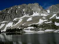
![Baptie Lake View]() Baptie Lake
Baptie Lake
Baptie Lake is at 10,150 ft. and is a small round lake sitting in a bowl between two rocky ridges. The Eastern edge has a thin forest of stunted, wind-blown limber pines growing on a rocky ledge that falls quickly to the canyon floor. The southern side is a steep talus slope and boulder field crowned by a high snow capped band of cliffs rising up and becoming the East ridge of Peak 11887. The eastern side is a large rocky wall rising up 300 feet to the edge of Goat lake, Idaho’s highest lake. A small cascade of water tumbles out of Goat Lake and roars into Baptie Lake.
When we arrived there was still ice clinging to the edges of the lake and large snowdrifts all around. We were still able to find a great campsite, one that apparently sees many visitors because it has an established fire ring, and a table and chairs all ingeniously made out of rocks.
After preparing a “scrumptious” feast of MREs and rye crackers that tasted like they’d been made out of sawdust and hadn’t left the package since WWII, we decided to head up to Goat Lake and Standhope Peak. A few yards up the trail we discovered that it was still covered with a snowdrift for some distance. Not having the proper equipment for snow travel we either had to turn around or find another way up. We opted to find another route up which involved some class 3 climbing through the rocks up to Goat Lake.
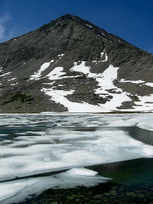
Goat Lake sits at 10,438 ft. making it the highest lake in Idaho. It is completely above treeline and lies in a spectacular basin between Peak 11887 and Standhope Peak. At the time we were there it was still mostly frozen over but much of the snow had melted leaving only a few places with snow.
![Standhope Ice]() Standhope Peak and Goat Lake.
Standhope Peak and Goat Lake.
Brittany didn’t care much for the climb up to the lake so she opted to stay there while I climbed the
Southeast Ridge of Standhope.
My first obstacle was a mushy snowfield at the base of the Goat/Betty Saddle which required me to go around it on some pretty unstable talus. I didn’t have any snow gear with me so I wasn’t too keen on walking through the mushy snow and not being able to see what was underneath. After about 15 minutes I made it around the snow and onto the saddle. This was really the only snow obstacle on the entire route as most of it had melted off the ridge.
From the saddle the Southeast Ridge looks quite imposing, steep, and unstable. In reality the rock is quite solid on the route and there really isn’t too much exposure making it a solid class 3 climb. It is quite steep however so that much at least was true.
I began my scramble up the ridge taking the fantastic view of
Altair, Standhope, and 11887. As I got higher
Pegasus and
Pyramid peaks began to be visible over the shoulder of Altair, followed by Big Black Dome, and finally an amazing view of the Lost River Range in the distance. The scramble was quite enjoyable as it was challenging but not exhausting. All along the route the winds grew stronger as I climbed higher into the deep blue sky until I had to hold onto my hat so it wouldn’t blow away and down a thousand feet to Goat Lake.
![Peak 11887 from Standhope]() 11887 from Standhope.
11887 from Standhope.
Once I reached the top I was greeted by one of the most fantastic views I have ever seen. Five distinct mountain ranges were visible; all five of them among the highest and wildest ranges in Idaho. The White Clouds, Boulders, Pioneers, White Knobs, and of course the Lost River Range sprang up in front of me like giant walls of jagged rock. I was in heaven!.... or at least pretty close being at 11,878 ft.
I found the summit register in an old Pringles can inside a plastic bag and signed it. Then I heard Brittany yelling from below. Not knowing if she needed help or was just wondering if I was ok I yelled back and waved my jacket over my head hoping she would see it 1400 ft. below me. Wishing I could stay longer but not knowing what was going on with my wife below I decided to head down the mountain.
Time to Go Home
![Pioneer Triumvirate]() The Pioneer Crest.
The Pioneer Crest.It took me a bit longer to go down than it did to go up as is usually the case and I had no major falls. By the time I reached the saddle again my legs were a little bit wobbly from the downward strain on the rocky, unforgiving terrain. Other than that I was ready to go back up another mountain after a drink and a bit of rest.
When I reached Brittany I was greeted by a beautiful smile and a hug and a kiss. I was glad that she’d agreed to come with me. It was the best welcome I’d ever had at the end of a climb! She’d been waiting for me and when she’d lost sight of me she began to worry (as all good wives probably would!). She waited a little more and then began yelling for me. By then I was at the summit and I could hear her but not understand what she was saying. I wish we’d have had a radio or something so I could have stayed longer.
I wanted to climb another mountain but Brittany was ready to go back to camp. I remember that she agreed to come with me if I didn’t push her too hard and helped her have fun so I had to give in. We went back to our camp at Baptie Lake and spent the rest of the day in camp talking and enjoying our time together in this beautiful place. It was actually quite a fun afternoon!
That night it was difficult to get to sleep as there would be a gust of wind coming down from the mountains that would rattle our tent every 10 minutes or so. Finally we were able to get some sleep and the next morning dawned bright and calm.
It was sad to leave our beautiful campsite but the prospect of real food and a hot shower were exerting a strong pull on both of us. We packed up and headed down the mountain at about 10:30 AM, passing through areas that we hadn’t seen on the way up due to the darkness. Both of the creek crossings went without incident and the only complaint we had was that Brittany’s heels began to get sore and blistered. After applying some first aid tape to her heels things went much smoother and there were no more complaints.
About ½ mile from the trailhead I suddenly turned around and exclaimed that I had left my stove at our camp. Brittany shot me a lethal look, reading through my joke. “Too bad”, she said..... she wasn’t taking it.
![Big Black Dome]() Big Black Dome
Big Black Dome
We reached the trailhead about 3 hours after leaving camp and were quite relieved to get into an air conditioned car with soft seats.
My original intention was to climb Big Black Dome on the way out but once again I had promised to get Brittany home as fast as I could so I had to pass it up. I figured I’d rather have my wife than another mountain climbed.......
The trip was a success. I climbed a mountain that I’ve always wanted to and my wife still loved me. I don’t think there’s any success greater than that!
So, now that I’ve seen other peaks in the Copper Basin Pioneers that made my mouth water I’ll have to plan another expedition for some future date. The peaks will always be there and as long as they are I’ll be here to climb them.
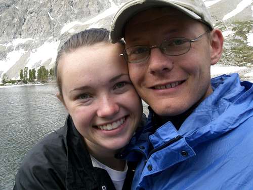
![All Smiles at Baptie Lake]() Happy As Can Be!
Happy As Can Be!Photo Album
To see my pictures from this trip check out the
Standhope Peak 2008 album.


Comments
Post a Comment