
|
|
Canyon |
|---|---|
|
|
36.03328°N / 111.01753°W |
|
|
Hiking |
|
|
Spring, Summer, Fall, Winter |
|
|
Overview
 Hoodoos Towering Above
Coal Mine Canyon is a beautifully colored canyon located on the Navajo Reservation in Northern Arizona. The canyon was originally named "Honoo Jí" by the Navajo, which means "saw-toothed or jagged erosion". Coal Mine Canyon Canyon is filled with hundred and hundreds of hoodoos that are similar in character to the ones found in Bryce Canyon (Utah). Although these two canyons share a common geologic structure, he main differences between the two is elevation. Bryce Canyon sits at 8,000ft while while Coal Mine Canyon sits at 5,000ft. They have different climates obviously because of that. Geologically speaking, there are few million years that separate these different rock formations.
 Coal-the Namesake
The name "Coal Mine Canyon" comes from the large quantities of coal (shocker, I know) found in the canyon. This area is geologically interesting not only for the interesting coal deposits, but also for the vast amount of fossils that can be found around the upper areas of the canyons. Also, three geologic formations, Dakota Sandstone, Cow Springs Sandstone and the Carmel Formation, are exhibited throughout the canyon making it a prime hangout geologists and paleontologists. For those not interested in the physical aspects of the rocks, the canyon provides an amazing example of beautiful array of color typical to rocks of the Colorado Plateau.
gralpinist says "For the lucky few, one can go to the edge of the canyon on a summer night, with a full moon and see a shimmering image of what we called 'The Ghost'."
Hiking Info
There are really no established trails in the area. What you have to do is pretty much pick a route that looks good and follow it into the canyon. If you look carefully, you can pick a nice route down into the canyon. From the dirt roads, you can usually pick up "use" trails and follow them down through the obvious weaknesses in the canyon. Most choices will be fairly steep and loose (silty). Going down is usually easier then going up because of this fact. There are faint trails throughout just from use, but they dart all over. Once inside the canyon, more well defined trails begin to sprout up making travel a little bit easier. So its pretty much of trail Silty Scree Slope
 Use Trail
Geology
Here is a report that I had to do for the field trip. Remember, I am a noob geologist. Mudstone with Mississippian age fossils
 Click for rock details
The Dakota Sandstone, Cow Springs Sandstone and the Carmel Formations can be seen exposed in Coal Mine Canyon, which is roughly fifteen miles SE of Tuba Springs Arizona. These two formations were deposited in the Middle to Late Jurassic. These two rock units are part of the larger San Rafael Group, which is spread all across Utah, Arizona, Colorado, New Mexico and Wyoming. Although it covers vast distances, it is found in greatest quantities in the Four Corners Area of the Colorado Plateau. The San Rafael Group is named after the San Rafael Swell in Southeast Utah. These correlated rock units all share some of the same characteristics concerning depositional environments. These rock units all consist of sandstone, siltstone, or shale.
The Cow Springs Sandstone is a smaller part of the larger Entrada Sandstone, which is very prevalent across most of the Four Corners Region. The Entrada Sandstone can be found up in the San Rafael Swell, Capitol Reef National Park and Goblin Valley State Park in Utah. Some of the depositional environments of the are tidal plans, mudflats, beaches and sand dunes. There are similar variations of the Cow Springs Sandstone found in Utah, however; the Cow Springs Unit is only generally confined to Black Mesa Basin of Northeastern Arizona. Interestingly, the Cow Springs Sandstone in this area contains copious amounts of coal and uranium deposits. Because of this, the Cow Springs Formation is seen as an economic resource throughout this area. Lateral from Coal Mine Canyon, the Cow Springs Formation is exposed again on the west side of Glen Canyon and Lake Powell along the border of Utah and Arizona. In places like Wahweep and Rimrock Hoodoos, it demonstrates the same erosion characteristics as Coal Mine Canyon. Also, the colors are strikingly alike as well. Below are two pictures of the Cow Springs Sandstone from around Big Water, Utah and then Coal Mine Canyon.
 Coal Mine Canyon
 Rimrock Hoodoos
As one can see, these two pictures bear a striking resemblance to each other. Although they are not the exact same rock unit name wise, they were both deposited in the Middle Jurassic and have many of the same erosional patterns and color.
The Carmel Formation lays underneath the Cow Springs Sandstone. Named after Mt. Carmel in Utah, the Carmel Formation is composed mainly of siltstone and mudstones that are gypsum rich that were deposited in the Middle Jurassic. Fossil are prevalent throughout the formation and is a popular destination for paleontologists. Its rock units are believed to been from a low energy depositional environment that is consistent a coastal environment. Like the rocks in the San Rafael Group, the Carmel Formation is distributed all across the four corners area, but is concentrated more heavily around Southern Utah and Northeast Arizona. In Coal Mine Canyon, it is found under the Cow Springs Sandstone. Laterally, the Cow Springs Sandstone begins to disappear and the Carmel Formation is topped by the Dakota Sandstone. In Coal Mine Canyon, the Cow Springs Sandstone is topped by the Dakota Sandstone, but as you head north across the border into Utah, the Cow Springs Sandstone begins to fade out. Laterally, it can be found in Southwestern Utah around Gunlock.
 Carmel Cross Bedding
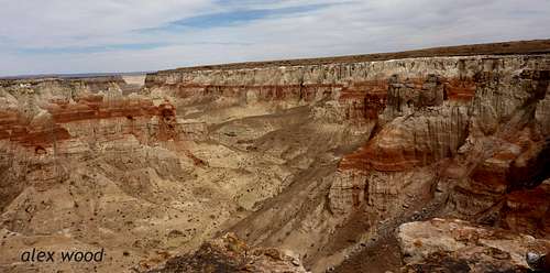 Looking at all the formations
Red Tape
There is no restrictions in Coal Mine Canyon. There are houses and private land in the vicinity, but other then that, there is no red tape to the area. The Navajo and Hopi have allowed free access to this canyon, but the surrounding areas may not have the same access. Check on the Navajo Parks and Recreation PageCamping
 Colorful Walls
 A Mini Arch
There is really no primitive camping in the area a]s it is surrounded by the Navajo and Hopi Reservations. Apparently, there is a campground located really close to the canyon called Coal Mine Canyon Campground. Other then that, the closest lodging would be in Tuba City or Page. Primitive and established camping can be found at the Glen Canyon National Recreation Area, which is around an hour and forty-five minutes away from Coal Mine Canyon.
Getting There
From Tuba City- Tuba City is on the Navajo Reservation and almost exactly in the middle of Page and Flagstaff. Both are an hour and a half away from Tuba City. From Tuba City, head South on Highway 264 towards Moenkopi and go through it. From Tuba City to the most popular viewpoint, its 16.4 miles. Take a left here on a small (well maintained) dirt road to the canyons rim. There are Indian Roads that go all over the area. So you can pretty much pick a road that looks good and follow it alongside the canyon to any area that you want. Google Earth Overview. Click for details
External Links
Currnet Weather ConditionsThe current weather forecast for the Coal Mine Canyon Area by NOAA
Coal Mine Canyon
A page on Coal Mine Canyon by American Southwest
Discover Navajo
A page on Coal Mine Canyon by Discover Navajo
gralpinist - Jul 10, 2010 11:23 pm - Hasn't voted
Small corrections...Very nice trip report and photographs, Alex. I lived in Tuba City for 16 years, working at the US Public Health Service Hospital. Coal Mine Canyon was on our 'to do' list, as were many other areas of interest on the Navajo and Hopi reservations. Glen Canyon NRA is quite a bit longer drive than one hour...perhaps 2-1/2 hours. Tuba City is not quite in the middle of the Navajo Reservation, more on the Western side, as the reservation is very large, and extends into Utah and New Mexico. The best place for lodging would be in Tuba City, with Cameron (24 miles from Tuba) a back-up. For the lucky few, one can go to the edge of the canyon on a summer night, with a full moon and see a shimering image of what we called 'The Ghost'. I noticed that one website for Coal Mine Canyon mentioning that one needed a permit to go below the rim. Great trip report!
Alex Wood - Sep 22, 2010 3:17 am - Hasn't voted
Re: Small corrections...Thanks so much for the feedback! Its 2.5 hours from Flagstaff to Glen Canyon NRA. Maybe there is some confusion cause I am talking about the portion of Glen Canyon NRA by Lees Ferry. I'll call it an hour and forty five. Thanks! Ill note that in the page. I haven't heard anything about a permit system (I know that there are for other areas though).