
-
 8296 Hits
-
 84.14% Score
-
 18 Votes
|
|
Canyon |
|---|---|
|
|
34.45522°N / 119.65331°W |
|
|
Hiking |
|
|
Spring, Summer, Fall, Winter |
|
|
Overview


Cold Springs Canyon is scenic canyon located in the Los Padres National Forest, north of the city of Santa Barbara, California.
Generally speaking, the state of California has an arid climate and forest fires are a common accurrance. Needless to mention, the mountains of Santa Barbara are no exception to the general rule. We have had devastating fires that have ravaged the hillsides and destoryed countless properties. We have had two major fires in 2008 and 2009, but Cold Springs Canyon and a handful of other areas were spared.
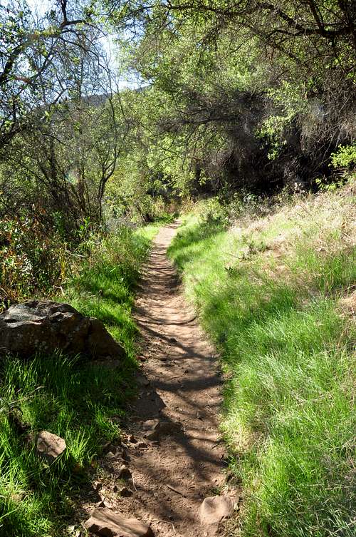
Cold Springs Canyon is arguably the most beautiful and enjoyable of all the canyons in the mountains of Santa Barbara. During the summer months you run into hikers hopping on boulders along the creek looking for their favorite swimming holes. In the spring time, the entire canyon comes to life with wild flowers and wildlife alike. If you are into bird watching, it’s hard to find many places in California that come close to Cold Springs Canyon. Tall trees line the year-round running creek creating shade for the trail. During the winter months when we receive the lion’s share of the yearly rainfall, Cold Springs Canyon turns into a sight to behold. A huge body of water cascades down the creek and over the boulders creating the most picturesque waterfalls.
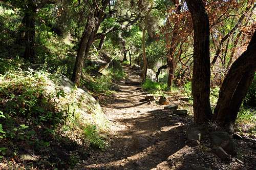

Typical to most of the canyons in the mountains of Santa Barbara, Cold Springs Canyon trail follows the creek for the first one third to half of the way to the top. The remaining miles to the top follow the side of the canyon and is a good distance from the creek.
Special note: There are two main creek crossings on the Cold Springs Canyon trail. These creek crossings can be very difficult and dangerous after a heavy rainfall.
.
Views of Pacific Ocean seen from the trail
 |  |  |
|---|---|---|
 |  |  |
A quick look at the trail to Camino Cielo Ridge
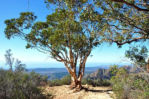
Twin Trees Overlook

One of many swimming holes.
Once you get some distance from the bottom of the canyon and tall trees, you begin to notice the breathtaking views of the Pacific Ocean and the city of Santa Barbara. Your first uninterrupted views of the coastline is after a mile and half from the trailhead, and it’s called Montecito Overlook. This is where a fire road intersects the trail. Most groups take a breather here.
From Montecito Overlook, the trail becomes noticeably steeper and you begin to pile on some altitude. Looking straight ahead, Montecito Peak with its dome-shaped hulk looms ahead. Your next stop to take in the views is at the “Twin Trees.” These are two Eucalyptus trees visible from miles away, and just under three miles from the trailhead. If you liked the views from Montecito Overlook, you’re going to love the views from “Twin Trees Overlook.”
Your final destination is Camino Cielo Road and end of Cold Springs Canyon hike. Continue on the same trail for another two miles to the top. During the summer months this canyon, and this hike, will be very hot. In addition there are no more sources of water. Making sure to stay hydrated is vital to having a great time.
Turn left onto East Mountain Drive and drive 1.1 miles to where it crosses Cold Springs Creek. About two hundred yards before the creek you will see a wide turnout on the right side of the road. Park here and walk up the road to the trailhead.
Note: There are two trailheads. The one on the right bypasses the creek crossings and ends up at the Montecito Overlook. The left trailhead follows the bottom of the canyon along the creek for the most part and ends up by Montecito Overlook also.
Your final destination is Camino Cielo Road and end of Cold Springs Canyon hike. Continue on the same trail for another two miles to the top. During the summer months this canyon, and this hike, will be very hot. In addition there are no more sources of water. Making sure to stay hydrated is vital to having a great time.
How to get to the trailhead
From the intersection of 101 and Hot Springs Road drive 2.2 miles to it's intersection with East Mountain Drive.Turn left onto East Mountain Drive and drive 1.1 miles to where it crosses Cold Springs Creek. About two hundred yards before the creek you will see a wide turnout on the right side of the road. Park here and walk up the road to the trailhead.
Note: There are two trailheads. The one on the right bypasses the creek crossings and ends up at the Montecito Overlook. The left trailhead follows the bottom of the canyon along the creek for the most part and ends up by Montecito Overlook also.