
-
 12319 Hits
-
 84.13% Score
-
 18 Votes
|
|
Mountain/Rock |
|---|---|
|
|
50.79118°N / 115.34683°W |
|
|
9104 ft / 2775 m |
|
|
Overview
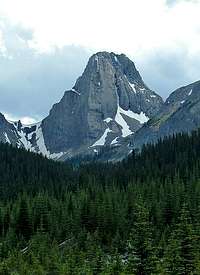
 Commonwealth Peak
Time: 5-11 hours
Height gain: 850 metres
Getting There
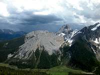
 Commonwealth Peak
 There are several options listed in the Kane book for descent. The way you came up. The fastest. Or decend to the col and return the north side to Commonwealth creek and out. The other is long via Smuts creek
Red Tape
 Commonwealth Peak
Peter Lougheed Provincal Park and Bow Valley Provinca
 Commonwealth Peak
 This is an extremly beautiful part of the Canadian Rockies. Please do your part to keep garbage out of the trees and off the ground. There are washroom facilities at some of the parking lots along the road, try and use these is possible.
When To Climb
 Commonwealth Peak
 Camping
 Commonwealth Peak
 There are other campgrounds in the area if desired.
Spray Lakes West Shore Campground has 50 sites (403) 591-7226
There is also the Alpine Club of Canada lodge with rooms and excellent facilities of 19$ CDN a night. The Alpine Club of Canada (403) 678-3200, ext 1
Engadine Lodge is a good base camp if you want some comfort at the end of the day.
Engadine Lodge
Box 40025 Canmore, Alberta T1W 3H9
Tel.: (403) 678-4080
Fax: 678-4020
E mail: lodge@mountengadine.com
Web address www.mountengadine.com
Mountain Conditions
www.weatheroffice.com for a weather forecastKananaskis Country Emergency phone # is 591-7767
Spray Lake Ranger Station. (403) 678-5533
Alberta Tourist Visitor Centre (403) 678-5277
The Alpine Club of Canada (403) 678-3200, ext 1
weather office or (403) 762-2088 for weather conditions
The summer months would be the most popular. June to end of September.