"Why again are we doing this?"
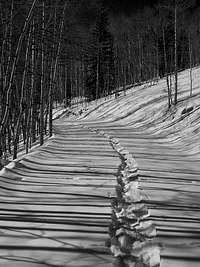
![Tracks and Lines]() Tracks and Lines
Tracks and Lines “Dang, Kiefer.” Stephanie let out laughing and sighing in perfect staccato. “We have got to get a new hobby. This is just crazy. I mean we’re either incredibly smart or incredibly stupid. I think I’m going to have to go with stupid.”
“You know, this whole trip reeks of our
Holy Cross debacle last January with Ben and Ryan.” I put a handful of snow in my mouth. “I think Holy Cross and San Luis are scheming and planning against us. They’re in Cahoots!” I exclaimed raising my finger in the air. I wanted to yell out
‘Science’, but I didn’t think Steph would get it, so I refrained. “We should have been back to camp like three hours ago.”
We finished off a few more handfuls of snow and chased it with pumpkin seeds and sour patch kids.
Our water ran out hours ago and the only stream we had come across in the back drainages was a thickly frozen rivulet splitting a forlorn and sad field of willows. Chopping the ice proved to be too arduous of a task without upsetting the underlying mud making the water undrinkable. We were both dehydrated.
“Oh, well. Let’s get going.”
“Sure.” I hung my head and closed my eyes. “This is the last uphill section than we’re home-free. I think we can find Pete’s tracks at least I hope, we can find Pete’s tracks. It’ll make things a whole lot easier.”
“Damn, that would be so sweet. Although, that snow cave we made was pretty neat”.
And so we retrenched across a very suspect slope in the dark which was a bit unsettling under the illumination of a single headlamp and falling snow as light as ash until we breached San Luis Pass.
We had crested San Luis Peak at 4:30pm, left the summit 10 minutes later and like a pair of ghosts no longer interested in haunting the backcountry, we disappeared into our sleeping bags around midnight only to be woken back up 30 minutes later by the sounds of snowmobiles from Search & Rescue.
Getting underway...
“Fact is a poor story teller. It starts a story as haphazard, generally long before the beginning, rambles on inconsequentially and tails off, leaving loose ends hanging about, without a conclusion…a story needs a supporting skeleton. The skeleton of a story is of course, its plot. Now, a plot has certain characteristics that you cannot get away from. It has a beginning, a middle and an end.…This means that story should begin at a certain point and end at a certain point.
--Somerset Maugham
Early on while planning a trip to San Luis, I decided that I didn’t want to blaze trip that far south. Driving from the Northern Front Range, the town of Creede is simply too far of a drive and too long of a hike. The point of this entire mountainous potpourri is to enjoy the journey as much as the destination, even if that means negotiating with Denver traffic
(lesson in futility). Stephanie and I settled on two days for the trip with a third just in case the unforeseen should happen or if we just wanted to take the ‘Long Way Home.’ I put out some feelers and invites for the trip but the only name to fall out of the roll-a-desk was Pete’s; an old and good friend I met on a group climb up Dead Dog via Summitpost.org a couple years back. So we were set with three of us. Considering we would be so far in the backcountry, the rule of ‘safety in numbers’ felt good to be following (for once!).
Stephanie and I left Ft. Collins (late) and crawled through Denver like a platelet in a plaque-filled artery arriving at Pete’s almost 90 minutes late. We swapped vehicles with Pete and traded up to a roomier erythrocyte (X-Terra) and were finally on the road. I called up
Steve Gladbach and said we’d probably keep on driving through Pueblo (vs. staying at his house) since it was so late to begin with.
We thought we’d brave the excitement-laden streets of Walsenburg for a cheap roach motel sans the roaches. We pulled into the Budget Host Motel and found we were only one of two cars in the entire parking lot
(queue creepy music). The desk clerk, an older woman who looked like a shar pei with a tanning addiction and a mouth full of teeth like broken pieces of Elmer’s glue gave us a single key. I’d be lying if I didn’t say it was a bit reminiscent of the 70’s. It was hard to shake that ‘B-grade’ horror movie feeling. It seriously felt like we had wandered into, “Wrong Turn”, “Cabin Fever”, “The Hills have Eyes” or anything with Nicholas Cage. Pete was already asleep in his bed so I had to roll over to Stephanie to share some randomness. “You know, Steph, Nicholas Cage could do a lot for this town.” I said flatly.
“What?!” Stephanie said absolutely confused and laughing almost immediately.
“Never mind, short story. Good night”. All things considering, I slept pretty good. It’s amazing how soothing the pitter-patter of roach feet can be.
I have an English degree from Colorado State in Ft. Collins. It’s something I pride myself on from time to time. But there are those moments that I honestly believe Stephanie’s dog, Zion has a better grasp on the English language than I do. Hell, since I’m a guy, I could simply be inept at following directions from the get-go. You see, we made a critical proof-reading error in regards to trailhead location. The slow drip of comprehension from Roach’s Fourteener guidebook simply wasn’t making it past our fleece hats or my blond locks.
In lieu of confusing ourselves even further by dwelling on whether or not we had brought the braille version, we parked at the road closure and started FROM the town of Creede. The Equity Mine trailhead was only a paltry seven miles up the road. This was not one of our brighter moments. Come to think of it, I have a suspiciously high number of those.
We all agreed however, that the walk in was rather nice. The weather was astoundingly beautiful, blue-bird skies, warm temperatures and a breeze as light as a dying man’s whisper.
When we reached the property boundary for the Emerald Ranch, confusion once again struck. After five miles of snowshoeing, the road was now plowed! How can this be? No one understood this but no one complained. The prospect of packing our snowshoes for two miles was delightful. And since Pete’s backpack was almost heavier than Zion, he was ecstatic.
We stopped briefly at the Equity Mine to admire views and read a couple of placards that were placed there explaining the history of the area. After hearing Ken Nolan and Steve talk about this approach, I was excited just to be standing there. Pete kept on trucking up the road since he was on a good pace/rhythm. Trail (road) #503 continued up and away to our left through the trees but the plowed, flat stuff stopped at an earthen embankment that doubly served as dam and holding pond.
After talking with the Mineral County Sheriff a couple days hence, Pete was able to find out the answer as to why the road is plowed clear to the mine and where we initially went wrong in our navigational efforts. Gold is still sifted and mined from the creek and higher placers and up in the hillsides, silver is still being extracted. So it’s actually profitable to keep the road open and plowed…interesting.
At any rate, we ambled like tortoises through the unbroken snow, mostly sugar and dry powder for an additional mile and a half. We set camp on the leeward side of a small copse of Evergreens and somewhat impatiently, waited out the night. I personally didn’t think it was all that cold out (Stephanie and Pete would disagree) but it was every bit as dark as I’ve ever remembered a night in the backcountry to be. The brilliance from the unfettered stars only added to the feelings of isolation and cryptic silence. In other words, it was a perfect night.
A Marathon Day
![Point 13,155]() Unnamed 13,155
Unnamed 13,155 In the morning, I wanted to head back down to the creek and fill up two more water bottles. While Stephanie stomped around trying to coax her toes back to life from a deep-freeze
(They weren’t having any of it), Pete headed off towards San Luis Pass. I rejoined a very uncomfortable girlfriend and irritated dog (Zion) who just wanted to get going.
Stephanie went second to garner a little harder work breaking behind Pete in hopes the blood flow would head south. We caught up to Pete fairly quickly as his feet were also having second thoughts about the temperature and boots of choice. I lead on an ascending traverse hoping to catch a break by reaching tree line, scree line or anything with rocks. Even with snowshoes, we kept sinking knee to thigh deep. Stephanie and I switched out leads. We kept a high traverse and hit the ridgeline above San Luis Pass a little below Point 13,300.
San Luis Peak looked absolutely majestic and from what we could see of the lower drainages, they looked absolutely miserable. From reading Steve’s report, he dropped down both drainages before attaining the saddle on Luis’ South Ridge. I wanted to try and mitigate this by staying high on the ridgeline, along the Continental Divide. After a few days of research, with the exception of one area, it looked like it could work. Pete had caught up with us.
“This is the end of the line for me guys. I can’t make it any further. Yesterday really did me in.” Pete stated while dropping to the tundra. Zion greeted him with a few barks and a wet nose.
“I was afraid you might say something like that. Your knee still acting up?” I asked.
“Not as bad as it did last summer after Mummy Mania or Ripsaw Ridge but I can feel it. I just don’t want to reinjure it. That’s all.”
“Understandable. It’s certainly not going to get any easier from here on out.”
“How long do you guys think you’ll be? Few hours?”
“We probably won’t be back till after dark.” Stephanie said.
“If you hang out for a little while, you could walk up to the summit of Point 13,300, It’s a ranked 13er. Should only be a class-1 walk-up from here.” I said. Stephanie and I strapped up and made ready. We decided the first part of the ridge wouldn’t be possible with a dog. So, we had some hard trenching to do through questionable terrain. Since the ridge immediately in front of us dropped off steeply enough, it corniced. We had to walk down slope to a gully that breached the ridge. We floated down like a pair of beach balls and stopped at a wooden CDT sign. I glanced back at Pete and saw him also descending (the 13er was apparently out). In all likelihood, he was taking a lower traverse back to camp…note to self. It would be almost 24 hours before we would see Pete again the following morning around 9:00am.
To begin, unless one is willing to just hump the 20+ miles from the standard Stewart Creek approach, coming in from the south, from Equity Mine is the only practical access point.
Knowing that both drainages are terrain traps, Stephanie and I wanted to minimize our time in these bowls and if possible, stay as high as we could. I initially wanted to take the ridge and climb the
Continental Divide over Points 13,300, 13,180 and 12,935. This ridge ends at a 4th class 13er UN 13,155.
The topo maps showed a prominent notch early on along this ridge and now that we had the chance to see it first-hand, there’s no way Zion could manage it under winter conditions. So we had to drop back to tree line.
Once we left the wooden CDT sign, we took care and trenched down the slope with care. We switch-backed frequently and followed the contours as best we could. This far isolated in what Stevie
(from Xtreme Mountain Sleds based out of Creede) calls a, “No man’s land” in winter, it wouldn’t be prudent to cut slopes just in order to save time. Plus thus far on this trip, the snow quality had been awful. We’d thus far encountered primarily sugar, Sahara-dry powder with a solid 2”-3” thick frozen top-layer. We didn’t encounter or hear that many ‘whoompfs’ (only three I can recall) but we did witness a lot of fracturing. When we reached the clandestine safety of the trees, we took a quick break, de-layered and breathed a sigh of relief.
Keeping a nod to our walk out for later in the day, we continued our weavings and meanderings through the trees to lessen the effort. I found an old, orange piece of plastic (trail marker) and took it. I tore it in four pieces and marked a few select trees. The trench of course would suffice for the way out but those occasional flickers of orange in the dark under the bravado of a headlamp do help with one’s motivation.
We finished the trees by hiking up a ravine to the far edge and popped out at the start of a willow field.
“This is gonna suck.” I mumbled to myself. Stephanie led the way through Swiss-cheese and willow-rooted snow while I lagged behind to fumble with my clothes. I kept trying to off-step her tracks to make the trench easier to follow on the way out. It was miserable work
(it usually is) but we eventually reached the next slope we had to attain.
We disagreed on route but after ample and a copious amount of switch-backing, we managed to reach the saddle in between Point 12,562 and Point 12,935. Looking back, our trench coming off the high ridge looked like a massively long old snake-skin or the leavings of some confused snowball.
When traveling in avalanche terrain, one of the things I like to do and it’s strictly a personal choice/habit is to stomp out a small area of compacted snow, usually around an exposed rock or tree if I can manage it. I’ll just compact the snow in concentric circles till I’m happy with a large enough area. I doubt it lends much stability to the route but it does offer me a small piece of mind. Plus when looking back, as I was now doing, they serve as a good reference point as to how far I’ve come and yet another confidence booster for the way back when the night is weighing down on ones confidence. I could actually see the place where Stephanie and I had stopped to lather sunscreen.
I spied a couple squirrels down slope from where we had just come.
“Hey, you woodchucks!” I yelled. “Quit chucking my wood!” Stephanie whipped around laughing.
“What are you on?!”
“I just wanted to give those squirrels a piece of my mind. Plus it helps keep me in a positive mood.” I said sheepishly. “Just look at em’ Steph. All cute, small and fuzzy. I bet they think they’re all that and a bag of acorns.”
“C’mon Zion. Let’s go. Things are getting weird.”
We walked up the remaining bit of easy ridge to the zenith of Point 12,935. I built up the small cairn that was already there, donned a heavier jacket and caught up to Stephanie and Zion who were already half-way to Point 13,155. Little did we know we had an unpleasant surprise waiting for us up a head.
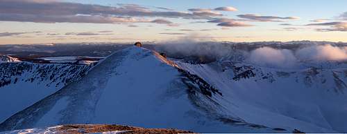
![San Luis Pass]() San Luis Pass in January
San Luis Pass in January One of the bad things about zooming in on topo maps is that the level of specificity is never detailed enough. Point in case, the Zodiac Spires in the Gore Range and the prominent but small 3rd-4th class ridge section that forced our retreat from the ridge crest. The flat and unbiased ridge that we were making such good time on came to a noticeable and abrupt end at some volcanic spires, like an old, broken and upturned battleship run aground on a reef.
My biggest question mark concerning this ridge was what did the south side look like? We never came across pictures or descriptions upon our research and the topo’s only show evenly spaced but closed contour intervals. I thought it might be possible to bypass any vulgarities on the ridge by way of the south side. That wasn’t happening. The south side was atypically holding A LOT of snow. The slope was well in excess of 40˚. So that pretty much forced us to the crest or occasionally traversing the north side. I started out leading, traversing the north side, sweeping & cleaning the rock and overcautiously testing the snow. It was absolutely terrible.
There was nothing fun about this.
We should have had a rope. The north side was also flirting with 40˚ but there was that one small advantage of having exposed rock to jam and mantle. I had to yell out at Zion multiple times to stay behind me (he didn’t seem to be having any problems) and had to re-route and change course twice. This was actually the most concerned and nervous I’ve been since climbing Capitol’s crux last January. I made it to a shallow access gully and up-climbed this to regain the ridge crest. Zion was sitting next to me. We waited for Stephanie to join us. I glanced over to the remaining 20’ or so of ridge and my heart sank. There was a 15’ section of what I would call 4th class knife edge than back to some 3rd class scrambling and class 2 for the duration. There was no way Zion was going to make that in one piece. I know Roach has this whole ridge as 3rd class but it is my firm belief that he’s never been on this entire ridge. Stephanie finally joined us.
“Steph, we have to turn around. There’s no way in hell Zion is gonna be able to make this last small section. Even for us it's gonna be dicey as hell. I can clear the snow as best I can but I don’t think we should chance it.” Stephanie took a look and peered down the north side chutes. She readily agreed. I was pissed. This was a lot of time. So we backtracked down the gully stopping at two ‘safe’ areas and as I was going to exclaim that we should just pack this whole shitball endeavor up, Stephanie says,
“Why don’t we down climb further to that large boulder and just traverse lower down. It’ll get us to the scree slope. It’s just more vertical but should be safer.”
I didn’t say anything for a few moments but agreed. We left the safety of the large boulder and traversed a line
(not exactly the best choice) that I would say was at a lower break line on the slope. I took massively huge steps to minimize cutting a solid line across this. Soon enough, the three of us were sitting at the bottom of Point 13,155. It’s amazing how once you’ve been immersed in hard to difficult terrain, time and time over, the moderate stuff is all gravy. You pay less attention to the terrain as a whole and piece together informed decisions based on a gestalt.
“Do you want to climb up and get this summit?” Stephanie asked.
“No. We killed way too much time on that shitty ridge. San Luis is the main objective. I think we should stick to the plan.” I couldn’t believe I was turning down an additional summit. We still had 530 feet to descend to the saddle on San Luis South Ridge than a mile of easy class-1.
Success and Failure
![A winter s summit]() A successful Summit!
A successful Summit! San Luis’ South Ridge is the ridge that keeps on giving.
That damn thing just kept going on and on and on. I felt like I was on a treadmill. But after a while, we finally graced the summit at 4:30pm. It felt so good to be sitting there. Of the Fourteeners, San Luis is in my top-10 of the ones I wanted most. We didn’t stay long. It wasn’t windy by any means but the wind chill felt wicked. We cruised back down to the saddle by dusk and broke out heavier clothes. The sun was gone, the available light was dying quick and the sense of urgency was becoming heavier. There was no way we were going to retrace our steps. Having consoled ourselves to a posthole nightmare, we left the saddle and followed the CDT as best we could.
I broke out a couple glow sticks, snapped them to activate them and we tied them on the back of our packs to make us more visible to each other in the darkness. Zion is typically good at staying behind Stephanie so he wasn’t a worry about darting off. I wanted to contour around this massive ravine closer to the slope to avoid dropping down so far but in the end, we decided to ditch this idea and straight-lined it towards a buttress that came off the ridge we had travailed earlier. It was scoured to the point where a generous amount of talus was showing. We spied it on our way down from the summit of San Luis with the sole intention of using it as our access out of this second drainage. The post-holing was brutish and tiring. Stephanie had left her headlamp in the other pack so we only had mine to go off of.
We were climbing in the dark making dreadfully slow progress then possibly one of the worst things that could have happened (aside an avalanche), happened. The clouds came in, lowered and enveloped us in a complete white out. We only made it another, maybe 75 feet before we completely stopped.
“Steph, we can’t continue like this. I can’t see anything.” I said while plopping down.
“Well, can you make out any rocks? What about that rough stuff off to the left?”
“I think it’s just crenellations and sasturgi. We need to decide what we’re going to do.” I could tell she wasn’t comfortable with the situation. I was more irritated than anything else with the damn weather.
“We’ve got two choices. Either we continue up the slope blindly or we stay here and dig a snow cave. And just for the record, I’m not good with the first choice.” Stephanie agreed. So we took off our packs and started to dig a hole. We reached bottom, bare slope after 5’ or so and started shoveling out the sugar. We took turns digging horizontally down slope staying with the tundra. Before Stephanie had noticed that the clouds had departed, we had a fairly reasonable cave about 6’ long by 5’ wide and between 3’-4’ high. We were both shocked that the ceiling was staying remarkably intact despite the snow quality.
![Descending]() Looking south from San Luis
Looking south from San Luis Another 30 minutes or so and it would have been finished, accommodating two people and a dog. It wouldn’t have been the most comfortable place to sleep the night away but it would have served the purpose; we flipped-flopped as to whether or not to continue or just stay the night there. In the end, I wanted to keep going since we could see the stars again and the ever-so-faint makings of the ridge above us. We had killed an hour easy digging the cave. I led out first towards what looked like the buttress we studied earlier and success!
“Steph! I have talus in front of me. This is our exit! C’mon up!” I turned around to illuminate the trench. In no time, we were standing on the easy ridge and eventually, we crossed out tracks from earlier and followed them back to UN 12,935. For the conditions being what they were, my headlamp was freakin’ awesome, especially on the spot mode. We easily followed our tracks back to our snowshoe cache, drank the last few ounces of our water and followed the wise advice of Biff Tannen, ‘we made like a tree and got out of there!’
The trench was easy to follow on the way out as we knew it would be. Pete was probably wondering where in the hell we were. We lost maybe 45 minutes climbing out of the first drainage, an hour to 90 minutes on the ridge and an equal amount of time waiting out the white-out.
But for some reason I was in a super good mood despite the time or total blackness of the forest.
I raised both my arms out in a welcoming gesture “Change the scheme. Alter the mood. Electrify the boys and girls if you would be so, kind!” I said rather loudly. No response from Stephanie. “Did you know what movie that’s from? You were kinda surprised you liked it.”
“I have no idea.” I could tell Stephanie didn’t want to play. She was tired and actually more dehydrated than I was.
“Tron!” I said. “Ok. Let’s stop and melt some snow and eat a little bit.”
I leaned up against a tree throwing a few sour patch kids in my mouth.
“This is the last uphill section than we’re home-free. I think we can find Pete’s tracks at least I hope, we can find Pete’s tracks. It’ll make things a whole lot easier.”
“Damn, that would be so sweet. Although, that snow cave we made was pretty neat”.
We retrenched across a very suspect slope in the dark which was a bit unsettling under the illumination of a single headlamp and falling snow as light as ash until we breached San Luis Pass.
One of the things I enjoy about snowshoeing at night and the conditions have to be right for it, that is, no wind and cloudy is that such conditions makes one feel like they’re walking in a vacuum completely and utterly cut-off from everything else. It’s creepy, a bit unsettling and absolutely fascinating all at the same time. I’ve ventured into the backcountry now for long enough, in all seasons, where I personally look forward to the exceptions and contingencies.
We took a few more breaks en route to camp but when we got there, around 11:30pm, Pete was noticeably absent.
I hoofed it down to fill our water bottles and got back to find Stephanie already in the tent with Zion. “Hey. Pete left a message in the snow.” I said a little puzzled. “He’s gone out and activated the SOS button on his SPOT. Looks like he left about 10:00pm it says.”
“Why did he pack up and leave camp so late?” Stephanie was just as confused as I was.
“I don’t have the slightest.” I mulled this over for a few minutes while tearing off my gaiters. “You know, he’s actually put himself at a greater risk of danger by heading out alone with his limited experience.” I climbed into the tent and pulled off my boots.
“Why wouldn’t he just stay here and wait for morning? Or set his alarm for like 4:00am or 5:00am and push the button if we hadn’t shown up yet?” I just shrugged my shoulders.
“I wonder if SAR will come up tonight if he activated the SOS button.” Stephanie asked.
“If they do, I bet they run into him somewhere along the road. I wouldn’t be surprised if they did come up here. What do you want to do? Do you want pack up and head out after him or stay and sleep?”
Stephanie sighed. “I’m not going anywhere tonight.”
Not 30 minutes later, we heard the distinctive roar of snowmobiles making their way up the creek.
“I guess we have our answer.” I said. A lone snowmobile pulled in to our campsite and a guy got off. I poked my head out the tent. “Evening!” I proclaimed. I was actually feeling pretty good despite a long day. We discoursed as to our status, how long our day was, was Pete alright, etc. In the end, I learned Scotty, from Xtreme Mountain Sleds, regularly helps out Mineral County Search & Rescue. Out of eight people/sleds, he was the only one who made it this far in (1,000 cc engine). All the others had either turned because of the poor snow conditions or had gotten themselves stuck trying to side-hill. We also learned that if we hadn’t turned up by morning, they were going to send out a helicopter. In Scotty’s words, those back bowls are a, ‘No man’s land’. No one goes back there in winter. This more than anything, really hammered home the notion that not all mountains have to be technically difficult to be dangerous and that the SOS feature on those SPOT devices that so many have, works rather well. He also relayed that Pete had come across some rather large cat tracks.
“Damn, Steph. Pete’s lucky he didn’t become dinner.” Of course with all the snowmobiles, the cat tracks were all but gone come morning.
In the end, Pete met us at the Equity Mine at 9:00am much to our surprise. He found the ‘proper’ way in to the mine as parleyed by the sheriff and we drove out back to Creede where we gorged ourselves on pancakes and eggs. After a short stint at the sheriff’s (Fred) office debriefing the situation and enjoying Scotty’s company (He was one cool dude), we parted ways and made the long pilgrimage back home where we also discovered, Denver and the Front Range were getting hammered with a storm.
This trip had a lot of surprises, firsts and corrections. It was a successful trip not in that we made our goal of a successful summit, but that even with 20 years of venturing into the backcountry; every trip has lessons and opportunities to make the next foray safer, stable and more enjoyable, most of all, to stress the importance of communication.
Even class-1 mountains come winter, are not to be taken lightly.


Comments
Post a Comment